2018:473 - SWORDS: Oldtown (Phase 2), Dublin
County: Dublin
Site name: SWORDS: Oldtown (Phase 2)
Sites and Monuments Record No.: N/A
Licence number: 17E0104
Author: Kim Rice, Courtney Deery Heritage Consultancy
Author/Organisation Address: Lynwood House, Balinteer Rd., Dublin 16, D16 H9V6
Site type: Excavation - miscellaneous
Period/Dating: Multi-period
ITM: E 716325m, N 748450m
Latitude, Longitude (decimal degrees): 53.473223, -6.247745
The proposed Oldtown, Phase 2 development is in the townlands of Oldtown and Rathbeal, which are in Swords, County Dublin. In advance of works, Phase 2 consisted of two large fields that were separated by the Oldtown/Rathbeal townland boundary. Field 1 lay to the east of the tree-lined boundary, with Field 2 to the west. The site lies to the north-west of the Applewood Community Centre and Swords Educate Together, and to the north of the Rathbeale Road. Testing and monitoring in 2017 highlighted five areas of archaeological potential that were investigated in 2017 and 2018.
Area 1 encompassed the remains of five ditches; Ditches 1–4 partially enclosed two curvilinear gullies, while another gully, linear feature and pit were located outside the main concentration of features to the north-east. One of the gullies produced an iron billhook and a fragment of a rotary quernstone, which typically date to the early medieval period. It is likely that Ditches 1–4 are also early medieval in date, while the remaining features were characteristic of post-medieval field drains and refuse pits. The main concentration of features in Area 1 were recommended for preservation in situ.
A large water pit truncated by a series of gullies, drains and ditches comprised the Area 2 features. The water pit was comparable to other Bronze Age pits that were excavated in Area 5, as well as within the Phase 5 lands to the west. The pit was reused as a refuse pit during the early medieval period, while a series of later drainage features truncated the site in the post-medieval era.
Area 3 incorporated the remains of an isolated Early Bronze Age pit that produced pottery and lithics, while a penannular ring ditch was excavated in Area 4 to the south-west. The funerary monument, which was used sometime during the Bronze Age or the Iron Age, was filled with cremated bone and pyre debris. Another two post-medieval land drains truncated the ring ditch and a post-medieval refuse pit was investigated to the south-east.
Area 5 incorporated the remains of another large Bronze Age water pit, found in association with a burnt spread and two troughs. The water pit, which was comparable to the Area 2 pit, had been excavated to access and store water. Heated stones were then utilised to boil water in the pit and in two adjoining troughs. The site was reused and revisited on at least two occasions, as evidenced by two substantial recuts within the pit. The latest features onsite consisted of two post-medieval field drains that lay to the south of the main concentration of activity.
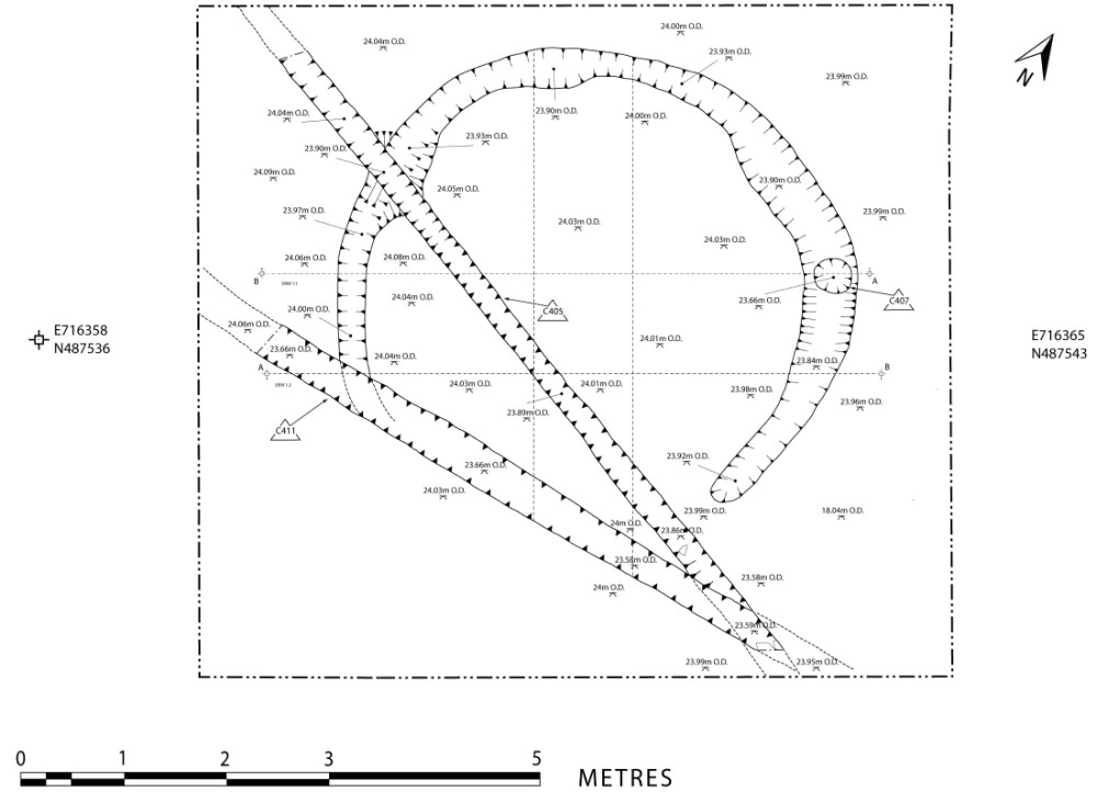
The fieldwork also resulted in the unexpected discovery of a substantial circular enclosure. The ditched enclosure was not identified during testing or monitoring but manifested itself because of differential vegetation regrowth after the topsoil was removed from the site. It measured 45m in diameter and presented as a broad grass ring that contrasted against the baked surrounding subsoil. A section was excavated through the enclosure ditch to investigate its form, fills and possible function. A buffer zone was established around the site and it is fenced off until a decision is reached regarding whether it should be preserved in situ or by record (i.e. fully excavated).