2018:734 - RINGASKIDDY, Cork
County: Cork
Site name: RINGASKIDDY
Sites and Monuments Record No.: N/A
Licence number: 17E0641
Author: Tony Miller, Mizen Archaeology
Author/Organisation Address: Mizen Archaeology, The Old Forge, Inishannon Co. Cork
Site type: House - prehistoric and Metalworking site
Period/Dating: Prehistoric (12700 BC-AD 400)
ITM: E 578614m, N 563883m
Latitude, Longitude (decimal degrees): 51.826777, -8.310255
Both monitoring and excavation were required at Ringaskiddy ahead of the large-scale soil extraction needed for the Haulbowline East Tip Remediation Project being carried out by Cork County Council. Monitoring was initially targeted on features located during earlier testing under Licence 16E0103 (John Cronin and Assocs.)
This large area of farmland overlooking Cork Harbour was divided into 5 fields. The features discovered had all been heavily truncated by ploughing. A small number of features were uncovered including a hearth in Field 1 and a possible roasting pit in Field 3. In Field 4 two adjacent bowl furnaces were excavated. The assemblage of iron-smelting slag has been preliminarily identified as belonging to the Developed Iron Age, between the 4th century BC and 1st century AD (GeoArch).
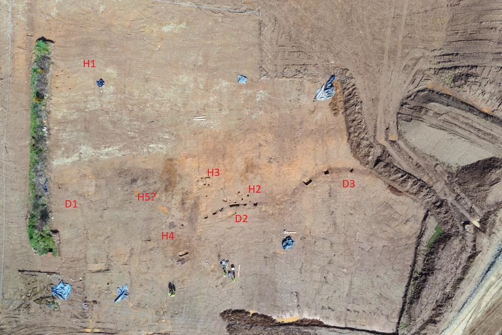
A larger area of prehistoric activity was found in the central area of Field 2. Here the footprints of four possible post-built house structures were identified. During surface cleaning fragments of Early Neolithic and Late Bronze Age pottery were found (Grogan & Roche).
Crossing east-west across this central area were three distinct linear ditches. The most easterly of these (C26) appeared to form the boundary of a large area extending beyond the site boundary to the east and south. It was separated from the central ditch (C44) by a narrow causeway, indicating they were probably contemporary. A single sherd of Late Bronze Age domestic ware was found in the upper fill of C44. The third ditch (C240) extended to the west beneath a retained field boundary and did not reappear in the adjacent field. A large number of stake- and post-holes and possible pits were also recorded.
Most of this central area of prehistoric activity was recorded in plan only. Sections were cut through the three ditches and some of the post-holes were fully excavated. It was then decided that the subsoil in this area would not be needed and the site should be reburied under supervision.