2018:676 - BANDON FLOOD RELIEF SCHEME, Cork
County: Cork
Site name: BANDON FLOOD RELIEF SCHEME
Sites and Monuments Record No.: CO110-019001
Licence number: E4481 (C578)
Author: Judith Carroll
Author/Organisation Address: Ballybrack Road, Glencullen, Dublin 18
Site type: Historic town and Milling complex
Period/Dating: Multi-period
ITM: E 549226m, N 555158m
Latitude, Longitude (decimal degrees): 51.746455, -8.735296
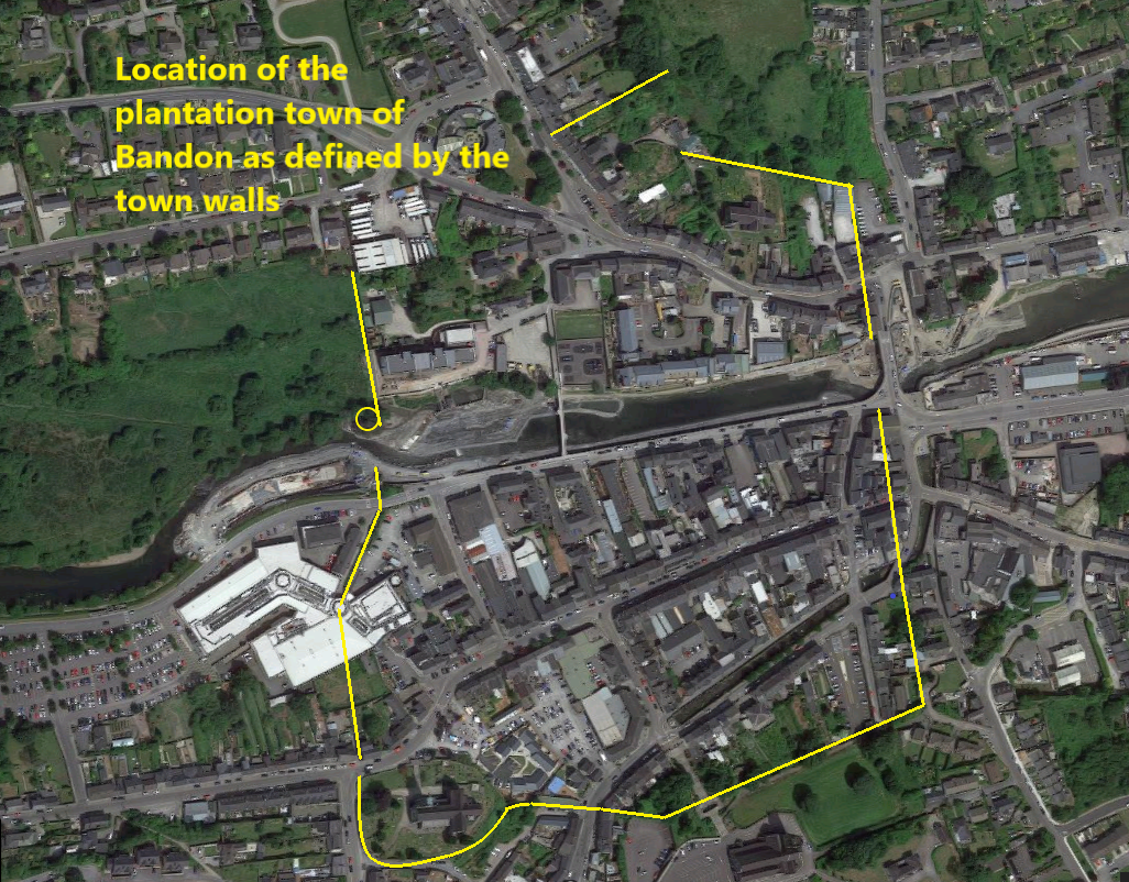
Judith Carroll and Company carried out the archaeological work for the Bandon Flood Relief Scheme on behalf of Wills Brothers Ltd, contractors for the scheme and has been ongoing since 2016 (see summaries for 2016 and 2017). The flood relief scheme had a major impact on the river within the area of the historic town of Bandon which is listed as a Zone of Archaeological Potential (ZAP) delineated by the defensive walls (RMP CO110-019-014) built around it in the early 17th century. This report describes works carried out in 2018 within the ZAP under Ministerial Consent C578, E4881.
In 2018, works in the ZAP continued with monitoring of dredging of the river as in 2017. This year, works were concentrated in the west side of the project, in particular in the area of the west line of the town wall on both sides of the river. Here, the town wall on the south side stood at the edge of the river bank while a tower on the north bank stood within the river. To the west of the tower were the remains of a large mill which had been destroyed by fire in 1968.
From the beginning of May 2018, works resumed in the river. The removal of a 12m section of the weir was monitored. The weir was repaired in its previously damaged area with stone from the weir. Apart from the section of the weir which was to be removed, the work that took place on the town wall, ‘island’ tower and remaining part of the weir comprised survey, recording and mitigation of the sites during the works by the contractors. Piling in front of the town wall on the south bank was proposed for its stability during works.
The contractor’s works around the island tower took place under ext. 14 of Ministerial Consent C578 and all works around the piling of the town wall under ext. 15. Vibration monitoring took place on a continuous basis around the town wall on the south bank and levels of vibrations were recorded. Apart from the monitoring of the section of the weir which was to be removed, the remaining part of the archaeological works comprised survey, recording and mitigation of the monuments during the works taking place by the contractors.
Monitoring also took place in Riverview Shopping Centre along the line of the storm drain which was some distance to the west of the town wall. The new pipelines at Riverview Shopping Centre were monitored between January and March 2018. The stratigraphy here revealed nothing of archaeological interest and confirmed that this area was a flood plain till the development of the present shopping centre.
During excavation for the east-west pile revetment wall in Mill Place, stone walls came to light in March 2018. Map comparisons showed that these were almost certainly the site of the old mill. While the mill had been known to have been present in this area, the evidence of the north-south test trench and the many SI pits, all monitored on the site, appeared to show that it had been completely demolished. It was now clear that remains were present and testing and excavation of the site took place under Extension 13 of C578. Excavation was completed by 24 April 2018. The remains of the mill built c. 1788 were found while there were no remains of earlier structures.