2017:860 - ARKLOW/GLENEALY/ROUNDWOOD, Wicklow
County: Wicklow
Site name: ARKLOW/GLENEALY/ROUNDWOOD
Sites and Monuments Record No.: N/A
Licence number: 16E0486 ext.
Author: Seán Shanahan & Thaddeus Breen; Shanarc Archaeology Ltd.
Author/Organisation Address: Unit 39a, Hebron Business Park, Hebron Road, Kilkenny
Site type: Excavation - miscellaneous
Period/Dating: Multi-period
ITM: E 724648m, N 692449m
Latitude, Longitude (decimal degrees): 52.968300, -6.144320
Archaeological monitoring of environmental testing at Arklow, Glenealy and Roundwood, Co. Wicklow was monitored between 21 March and 28 June 2017, as part of a wider scheme to rehabilitate the existing water mains in the towns of Arklow, Rathdrum, Glenealy, Blessington, Laragh and Roundwood, Co.Wicklow.
The objective of the monitoring was to conduct a watching brief of all ground disturbance works at the development site, for the purpose of identifying any archaeological features, deposits or artefacts that may be present and which could be impacted by ground works.
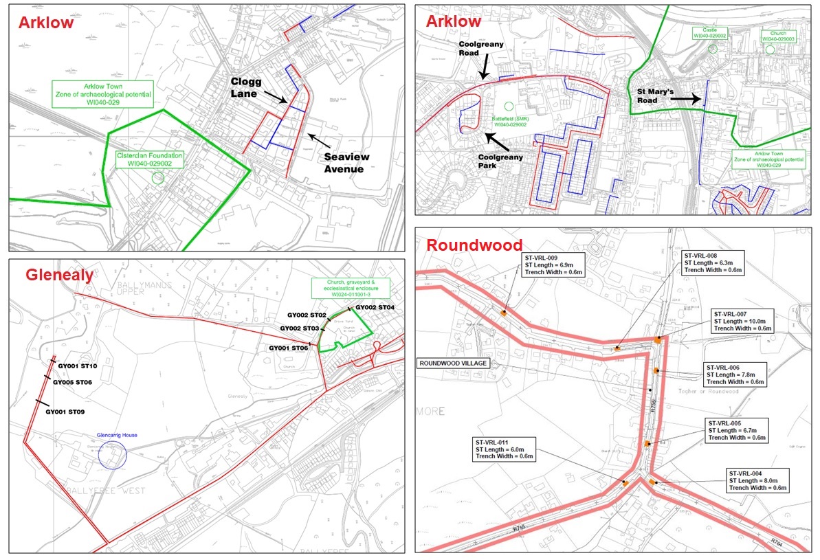
Monitored excavations in Arklow comprised the excavation of slit trenches and test pits at Ferrybank, Seaview Avenue, Clogg Lane, Coolgreany Road, Coolgreany Park and St. Mary’s Road.
Monitored excavations in Glenealy comprised the excavation of slit trenches in an area adjoining an ecclesiastical enclosure with church and graveyard (WI024-011001, WI024-011002, WI024-011003), and on greenfield sites at Ballyfree Farm.
Monitored excavations in Roundwood comprised the excavation a number of slit trenches across roads at the southern end of the town.
No archaeology was found during monitoring in Arklow or Roundwood. The only find of archaeological interest was a stone structure found in slit trench no. GY002-ST03 in Glenealy. This was probably associated with a well shown on the OS map of 1837-40 and may have been a culvert bringing water under the road; the 25-inch map shows what seems to be a stream running alongside the road. In view of its location near an early medieval church site, however, two other possibilities should be considered. Firstly, the possibility that it is a souterrain. These were underground passages used partly as refuges and escape routes and partly for storage. This feature, however, appears to be too small to be a souterrain. Secondly, there is the possibility that the well may have been regarded as a holy well. If it was, however, there was apparently no memory of it in the area when the Ordnance Survey map was being prepared c. 1840.