2017:740 - KNOCKNASHEE, Knocknashee Common, Sligo
County: Sligo
Site name: KNOCKNASHEE, Knocknashee Common
Sites and Monuments Record No.: SL032-013004
Licence number: 17E0339
Author: Cormac McSparron and Dirk Brandherm
Author/Organisation Address: School of Natural and Built Environment, Queen's University Belfast, BT7 1NN
Site type: Hillfort
Period/Dating: Bronze Age (2200 BC-801 BC)
ITM: E 555638m, N 818902m
Latitude, Longitude (decimal degrees): 54.117257, -8.678535

Knocknashee is a visually impressive, flat-topped limestone hill, situated centrally within Co. Sligo, rising to an altitude of 261m above the surrounding countryside. The summit plateau measures approximately 21.5 hectares and is enclosed by a series of low earthworks (SL032-013001). Located within the enclosed area are two megalithic tombs (SL032-013002 and SL032-013003) as well as the footprints of at least 51 roundhouse sites (SL032-013004), identified by previous survey work (Condit et al. 1991; Carty 2004; Egan et al. 2005; Brandherm et al. 2018).
For two weeks during the summer of 2017, from the end of July through the first half of August, an excavation was carried out at three of these roundhouse sites, by a team from Queen’s University Belfast, generously funded by the Research Excavation Grants Scheme of the Royal Irish Academy.
The primary aim of the excavation was to establish a secure date for the roundhouse occupation at the site, which had been tentatively dated to the Neolithic by some previous researchers, based on the close proximity of the houses to the megalithic tombs, and on the established Neolithic date of similarly situated roundhouses on Knocknarea (Egan et al. 2005). At the same time a Bronze Age date for the earthworks had been generally accepted and the site consequently has been classified as a hillfort (Condit et al. 1991).
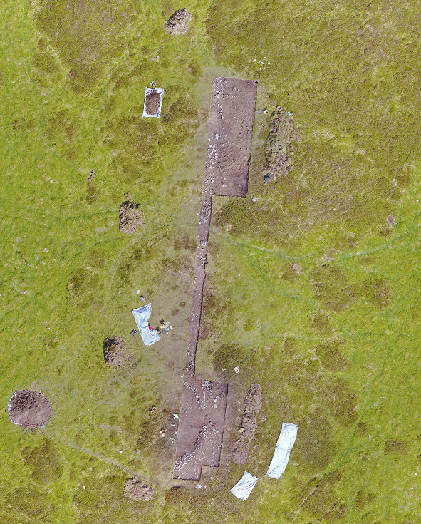
Already in the summer of 2016, a cluster of three roundhouse sites in the southern half of the summit plateau had been surveyed with geophysical methods (Brandherm et al. 2018), and it was this cluster (House Sites 18, 19 and 20) which was targeted in the excavation. A single trench was excavated through all three house sites. The trench measured 35m in length and was orientated approximately north-south, varying in width. The southern 9m of the trench were 4m wide, narrowing to 1m wide from 9m to 25m before widening to 4m again. This was to allow an examination of a greater section of the walls of these buildings and to detect any possible entrances or other structures associated with their entrance situations.
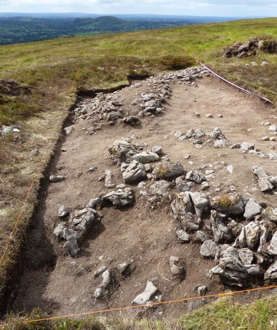
The houses seem to have been built upon raised platforms set into the slight slope of the summit plateau. A layer of grey clay deliberately brought in as flooring material was found in the interior of the southernmost house, House 20. No similar flooring was found in the interior of the house immediately abutting to the north, House 19, possibly suggesting that this somewhat larger structure may have been an ancillary building, potentially not intended for human habitation. The walls had a stone core, around which individual dumps of earth had been placed before the final facing of the wall in stone. An entrance to House 20, measuring 1.2m in width, was revealed in the east wall. Several fragments of, probably Bronze Age, coarse pottery were found in the entrance area to the house, which also produced some chert flakes. Other finds from House 20 include two fragments of polished stone discs. House 19 produced hardly any archaeological material, save for a couple of small pieces of chert.
The walls of the northernmost house excavated, House 18, were composed of stones which were fewer, smaller and more randomly scattered than those defining the walls of Houses 20 and 19, and it seems likely that the walls of this house had been dismantled and the stone removed for use in other structures already during prehistory, indicating that not all the houses on the plateau were in contemporary occupation. However, according to the series of radiocarbon dates obtained from the excavation, all three houses can be attributed to the Late Bronze Age (1260–815 cal BC at 2 sigma; based on radiocarbon determinations from ten charcoal samples undertaken at QUB’s 14CHRONO Centre), which is in line with the dating of hillforts in other parts of Ireland.
The excavation of the wall of House 18 produced a considerable quantity of lithic material, mostly debitage, but also including one fine butt-trimmed flint knife of likely Late Mesolithic date. Given the location of the flint within the walls, it is probable that this is redeposited residual material from earlier, previously undetected activity on the summit of the hill.
The excavation has answered each of the questions posed. We now can say much more about how the houses on Knocknashee were constructed. We have also determined that most of the activity relating to these structures seems to be Late Bronze Age in date, which fits well with the suggestion that Knocknashee was a hillfort, and we can finally say that all of the roundhouses at Knocknashee were not in contemporary use, with evidence of stones being robbed from House 18 for use in other ancient structures on the hilltop.

References
Brandherm, D.; McSparron, C.; Kahlert, T. and Bonsall, J. 2018. Topographical and geophysical survey at Knocknashee, Co. Sligo: results from the 2016 campaign. Emania 24, 81-96.
Carty, M. 2004. An Archaeological Survey of the House Sites on Knocknashee, Co. Sligo. Unpublished MA thesis NUI Galway.
Condit, T; Gibbons, M. and Timoney, M. 1991. Hillforts in Sligo and Leitrim. Emania 9, 59-62.
Egan, U.; Byrne, E. and Sleeman, M. 2005 Archaeological Inventory of County Sligo, Vol. 1: South Sligo, comprising the Baronies of Corran, Coolavin, Leyny and Tirerrill. Dublin, Stationery Office.
