2017:712 - ARDLOY (1 and 2)/SPRINGFIELD (4), Sligo
County: Sligo
Site name: ARDLOY (1 and 2)/SPRINGFIELD (4)
Sites and Monuments Record No.: N/A
Licence number: E004842; Ministerial Direction No.: A071
Author: Brian O'Hara & Lynda McCormack, c/o IAC Ltd.
Author/Organisation Address: Unit G1 Network Enterprise Park, Kilcoole, Co. Wicklow
Site type: Enclosure, Settlement cluster, Barrow - ring-barrow, Burial, Furnace and Pit
Period/Dating: Prehistoric (12700 BC-AD 400)
ITM: E 573676m, N 816988m
Latitude, Longitude (decimal degrees): 54.101297, -8.402480
Stage (iii) archaeological excavation was carried out at Ardloy 1 and 2/Springfield 4 in advance of the N4 Collooney to Castlebaldwin Road Development, Co. Sligo. The site was discovered during Stage (i) archaeological testing and was assessed during Stage (ii) Pre-Excavation Services (Registration Number E4627).
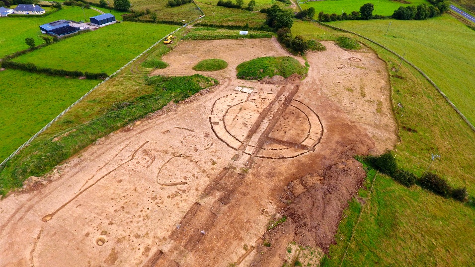
The subject site was located on the summit and south-facing slope of a low hill known locally as Taylor’s Hill. The site is located immediately to the north and west of Springfield 3 (E004802) and forms part of the same archaeological complex.
Excavation revealed extensive evidence for Middle Bronze Age habitation and Middle to Late Iron Age habitation and ritual activity. The principal archaeological elements consisted of two Middle Bronze Age sub-rectangular structures; an enclosure formed by a sub-circular double palisade with a circular structure to the interior and a rectangular structure located between the two palisades to the western side; three Iron Age circular structures, a ring barrow with five grave cuts located close by forming a ferta and a U-shaped ditch of Late Iron Age date. Other features uncovered included boundary ditches, a curving arc of post-holes forming a fence line, bowl furnaces and pits.
The two sub-rectangular structures were broadly similar in plan with curvilinear trenches at the gable ends and side walls formed by post holes. Both structures had porches with metalled surfaces to the south-east side. A sample of hazel charcoal from one of the structures returned a date of 1380–1130 B.C. at 2 Sigma Cal.
The trenches forming the double-palisade enclosure were equidistant from one another to the northern, western and southern sides. To the north-eastern side the outer palisade splayed away from the inner in order to accommodate a rectangular structure formed by six substantial post-holes. A sample of hazel charcoal recovered from the outer palisade trench returned a radiocarbon date of 341–49 B.C. at 2 Sigma Cal. To the interior of the inner palisade there was a circular structure measuring 12m in diameter. A charred hazelnut shell from one of this structure’s post-holes returned a date of 341–49 B.C. at 2 Sigma cal. The primary entry point to the enclosure was located to the east where there were gaps in both palisades. A second entry was located to the north formed by a gap in the outer palisade only. Two parallel alignments of post-holes orientated east-west ran from the circular structure to the eastern entrance.
All three circular structures were broadly similar in morphology being formed by 17 to 19 post-holes and averaging 9m in diameter. Two of the circular structures were located to the north of the double palisade on the summit of the hill and may have formed a ‘figure-of-eight’-shaped structure. Pomiodeae charcoal from a post-hole returned a date of 396–206 B.C. at 2 Sigma Cal. Evidence for iron production in the vicinity of this structure was provided by the presence of bowl furnaces and waste pits containing slag. The third circular structure was located off the summit of the hill toward the southern extent of the site in close proximity to the ring barrow.
The ring barrow was located on a south-facing slope. It was sub-circular in plan and contained a series of charcoal-rich fills with frequent inclusions of cremated bone. A single cremation pit containing a substantial volume of cremated bone was cut into the inner side of the barrow ditch. To the interior of the barrow were seven post-holes which may have formed a timber circle and a probable grave cut. To the north of the barrow a series of five sub-rectangular cuts were aligned east-west. Small quantities of human bone were recovered from two of these cuts and it is considered that all of the cuts probably were graves forming a Ferta.
The U-shaped ditch enclosed an area measuring 10m east-west by 9m and was open to the south-south-western side. It consisted of a shallow ditch with well-defined termini. Hazel charcoal from the fill of the U-shaped ditch returned a date of AD238–387 at 2 Sigma Cal.
Almost 300 artefacts were uncovered during the excavation including prehistoric lithics, a stone palstave axe mould, numerous corroded iron objects and two copper alloy objects. A total of 108 glass beads were recovered from the fill of the ring barrow.