2017:684 - KNOCKNAGROAGH (1), Sligo
County: Sligo
Site name: KNOCKNAGROAGH (1)
Sites and Monuments Record No.: N/A
Licence number: E004854; A071
Author: Bruce Sutton, c/o IAC Ltd.
Author/Organisation Address: Unit G1 Network Enterprise Park, Kilcoole, Co. Wicklow
Site type: Burnt mound
Period/Dating: Undetermined
ITM: E 569620m, N 821992m
Latitude, Longitude (decimal degrees): 54.146037, -8.464995
Stage (iii) archaeological excavation was carried out at Knocknagroagh 1 in advance of the N4 Collooney to Castlebaldwin Road Development, Co. Sligo. The site was discovered during Stage (i) archaeological testing and was assessed during Stage (ii) Pre-Excavation Services (Registration Number E4627).
The excavation at Knocknagroagh 1 recorded the remains of a burnt mound measuring 16.5m long, 16m wide and 0.5m deep.
A wood-lined trough was cut into natural clay contained three base timbers and 23 stake-holes, several of which contained degraded stakes. Several other smaller cut features were also present. Many of cut features had corresponding upcast natural clay adjacent to them.
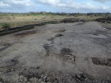
Post-excavation shot of E004854 looking east.