2017:466 - ATHBOY: Bunboggan, Meath
County: Meath
Site name: ATHBOY: Bunboggan
Sites and Monuments Record No.: N/A
Licence number: 17E184
Author: Antoine Giacometti and Steven McGlade, Archaeology Plan
Author/Organisation Address: 32 Fitzwilliam Place, Dublin 2
Site type: Kiln - lime and Road - road/trackway
Period/Dating: Modern (AD 1750-AD 2000)
ITM: E 671080m, N 764220m
Latitude, Longitude (decimal degrees): 53.622967, -6.925535
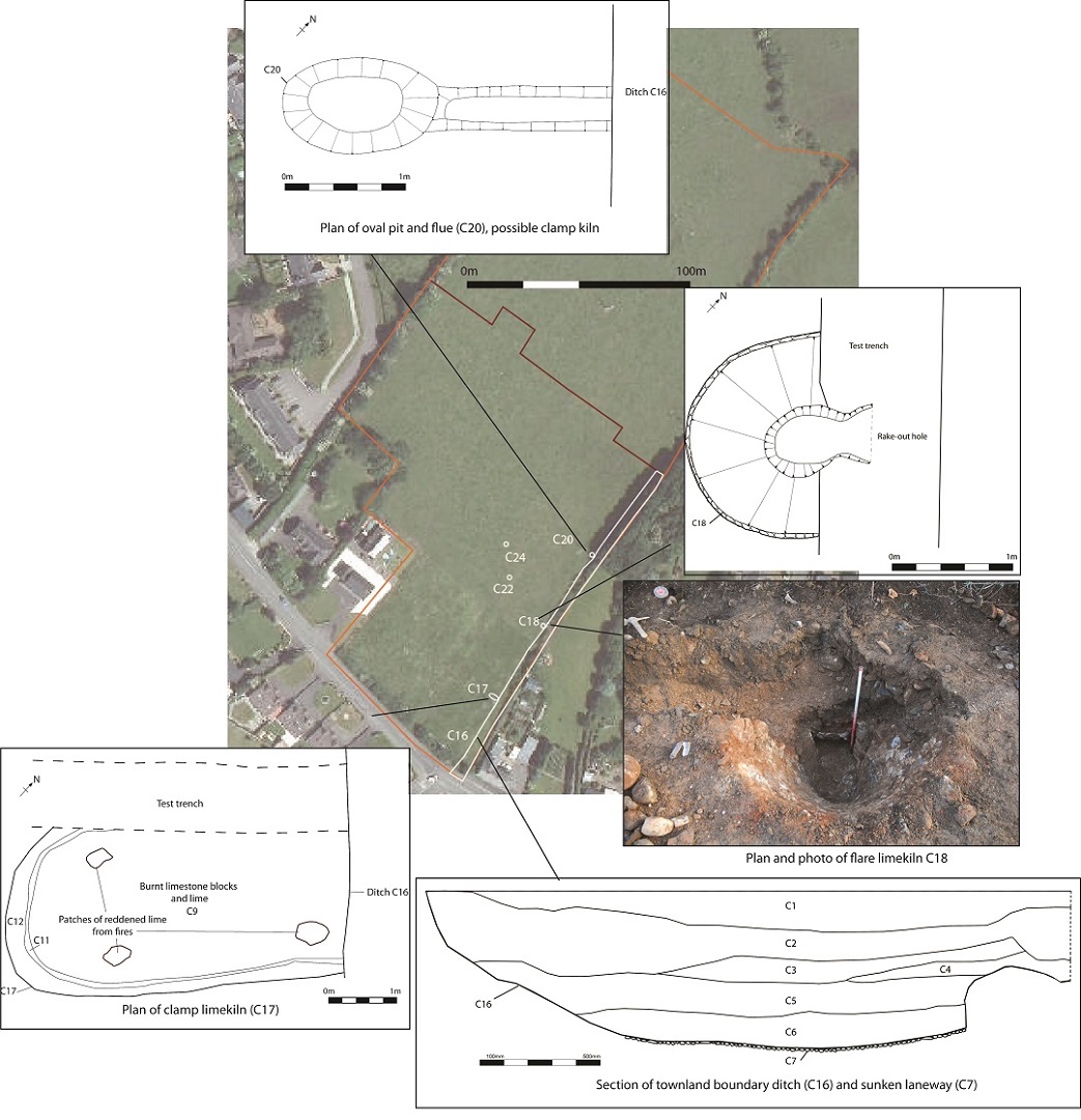
A programme of monitoring was carried out at Bunboggan, Athboy, Co. Meath in advance of a housing development. During the monitoring works two limekilns were uncovered to the east of the site. A townland boundary ditch marking the limit of Athboy on the 1830’s Ordnance Survey map was also encountered during the works. A further three pits with evidence of in situ burning were also uncovered along with a number of post-medieval field boundaries and the remains of 18th- and 19th-century buildings formerly fronting on to Connaught Street.
A north-east/south-west running ditch was identified running along the south-east side of the site. This corresponded with the boundary ditch marking the limit of Athboy on the 1830’s Ordnance Survey map and also formed the townland boundary. The ditch measured a minimum of 5.25m in width and 1.3m in depth to the south. To the north it was recorded at a minimum of 3m in width and 1.98m in depth further to the north. A cobbled surface was identified along the base of the ditch indicating it had also been used as a sunken access way. A laneway is depicted here on the 1767 estate map of Athboy and again on the 1830’s OS map. The laneway may have been sunken to create an access for the limekilns, though it is also possible the limekilns were established here due to the presence of the laneway.
To the west of the ditch two limekilns and a burnt oval pit and flue were identified. The southern limekiln was a clamp kiln consisting of a sub-rectangular pit running up to the townland boundary ditch and measured 5.1m in length, 2.44m in width and 0.58m in depth. A deposit of sand 0.3-0.35m thick lined the base and sides of the pit. Overlying this was a layer of limestone blocks and smaller stones measuring 0.23m in depth with the limestone burnt to lime in a many places. Patches of reddened lime identified around the kiln are likely to relate to fires set among the blocks to fire the kiln. The last firing of this kiln appears to have failed as the partially burnt blocks and lime remained in situ.
A second kiln was identified further to the north. This appeared to be the truncated remains of a flare kiln. No grate survived to suggest this was a draw kiln that could operate continuously, however this may have been removed prior to abandonment. The kiln consisted of an oval chamber 1.5 x 1.35m in plan, narrowing to 0.6 x 0.4m at the base, and was 1.22m in depth. The chamber was funnel-shaped in profile. It was lined with small sub-rounded and sub-angular blocks secured in place with a gritty white mortar and formed a solid construction. A rake-out hole was present at the base opening out towards the ditch to the south-east. It was a minimum of 0.26m in length and 0.5m in width. The south-western end of the limekiln was truncated by a test-trench, however it is likely that originally this fronted onto and was accessed by the townland boundary ditch and sunken pathway and would have been masonry fronted. The fill of the kiln suggested it had been backfilled after it had gone out of use.
An oval pit measuring 1.3m in length, 0.8m in width and 0.2m in depth was identified to the north of the flare kiln. It had a flue measuring 0.5m in width and 0.12m in depth running towards the townland boundary ditch. The pit had concave sides and a flat base. The natural subsoil below and to the sides of the pit and flue was burnt indicating a fire-related activity was carried out at the pit. It is possible this was the remains of a poorly surviving kiln, possibly a smaller clamp kiln that had been emptied.
The two kilns were approximately 37.5m apart, with the oval pit a further 37.5m to the north. The regular spacing of these features suggests that were located in separate plots. A further two small pits with in situ burning and charcoal-rich fills were identified to the north of the flare kiln. Given the proximity to the industrial features on the site these may relate to charcoal production for the limekilns.
A number of quarried areas, previously recorded during the testing programme, were also encountered during the monitoring phase.
The activity on the site related to small-scale and local lime production, likely to date to the 18th century.