2017:193 - NAVAN: Alexander Reid, Meath
County: Meath
Site name: NAVAN: Alexander Reid
Sites and Monuments Record No.: N/A
Licence number: 16E0449
Author: Steven McGlade, Aileach Archaeology, on behalf of Archaeology Plan
Author/Organisation Address: 32 Fitzwilliam Place, Dublin 2
Site type: Ringfort - rath, Kiln, Furnace and Burial ground
Period/Dating: Multi-period
ITM: E 689250m, N 766990m
Latitude, Longitude (decimal degrees): 53.645073, -6.650153
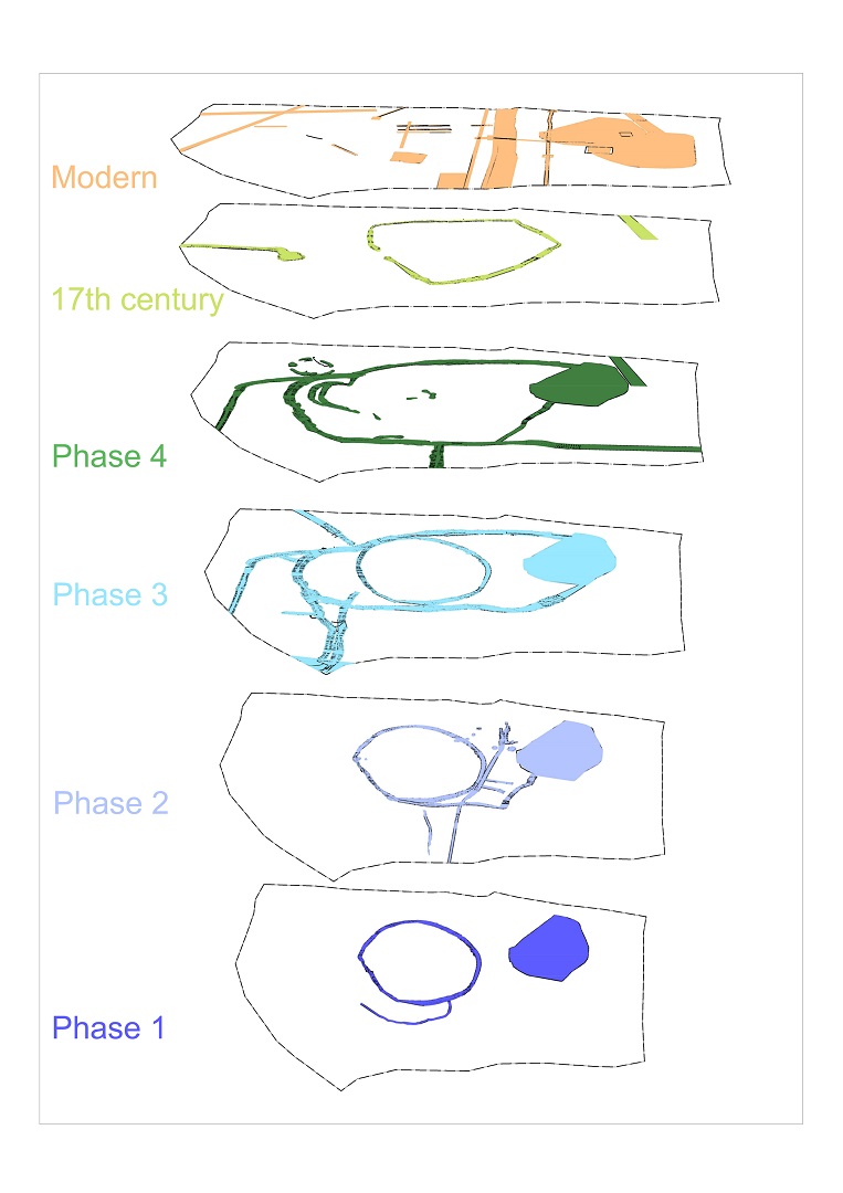
An excavation was carried out on a portion of a development site (Area D) at Alexander Reid, Navan Co. Meath from February to May 2017. Whilst some residual flint artefacts hint at an earlier phase of human activity in the vicinity of the site, the earliest archaeological features relate to an early medieval sub-circular settlement enclosure measuring 29m by 26m in diameter encircling the low hillock. The ditch defining the enclosure was narrow (1.02–1.12m) and shallow (0.4–0.53m) and is likely to have been significantly reduced. A number of annexes enclosed spaces to the east, south and west of the ringfort, and further ditches probably demarked field systems to the west, south-west and south. Although the site was heavily truncated in the post-medieval or early modern period, a number or features associated with the early medieval phase of activity on the site survived, such as kilns, a metalworking area, and storage and processing pits.
The early medieval settlement at Alexander Reid had a number of phases of evolution, with alterations to the enclosed spaces, layout, approaches and entrances. Evidence for metalworking, cereal production, weaving and animal husbandry indicate this was a self-sufficient community. Four phases of early medieval settlement were identified. The initial sub-circular settlement ringfort was expanded in Phase 2 to include an annex to the east. A wetland area or pond formed the eastern edge of the annex. The eastern annex was subdivided into a number of smaller enclosed spaces. One of these contained fire-related features such as kilns and hearths. The others may be garden plots. In Phase 3 the subdivisions in the eastern annex were removed creating a single enclosed space. Additional annexes were added to the west and south at this time. Phase 4 saw the settlement evolve further, with the original circular ringfort being amalgamated with the eastern annex and the inner western annex to form an irregularly-shaped central enclosure measuring 50m by 41m. A probable house structure belonging to Phase 4 was identified outside the enclosure.
Eleven kilns were identified along a north-east/south-west trend, with three of the kilns located in the centre of the former ringfort. These probably relate to the later Phase 4 of the early medieval settlement, by which time residential activity had shifted to the north-west. Figure-of-eight and keyhole-shaped kilns were identified, with the shapes seemingly influenced by their setting. Some were constructed within ditches and these tended to be keyhole-shaped. Three shallow circular pits were identified that may relate to the kilns. One of the pits had a metalled base while the base of the other two was formed by the underlying bedrock. These may be the remains of floors or threshing barns associated with the kilns. A bovine skull was retrieved from the base of the flue of one of the kilns, possibly a termination deposit. This kiln was subsequently cut by the Phase 3 ringfort ditch.
A number of entrances to the Phase 1-3 ringfort were identified, with two phases of entrance to the south-east appearing to mark the main entrance to the ringfort. The earliest of these was a metalled surface crossing the ringfort ditch measuring 1.76m in width. This was replaced by a paved surface measuring 1.9m in width, with a pivot stone set into the external side of the surface indicating the gate was location on the external side ditch. An early entrance was also identified to the north-west. Two poorly constructed Phase 4 access points were identified accessing the central enclosure from the north-west. Evidence for approaches to the entrances was also uncovered, with the Phase 1 approach to the south-eastern entrance being from the west. This shifted to being from the south in Phase 2.
Three early medieval structures were identified on the site. A small probable hut measuring c. 2.7m in internal diameter was identified in the southern end of the ringfort. This may relate to the nearby Phase 4 kilns. A semi-circular slot trench was identified at the southern end of the western inner annex, which may be the remains of a circular structure c. 4.5m in diameter, though could also be the remains of a windbreak. This appeared to relate to a Phase 3 kiln to the south. Outside of the enclosed space associated with the early medieval settlement a probable double-walled roundhouse measuring 7m in internal diameter was uncovered, relating to Phase 4 of the settlement. The slot trenches associated with the structure were truncated, though there was indication that the slots were segmented. Two gaps in the slots to the north-east and south-east indicate the location of doorways.
A metalworking furnace located within the Phase 3 annex ditch to the south-east of the ringfort and a fragment of crucible retrieved from the same ditch indicate that metalworking was being carried out at the site. Two possible anvil stones were also retrieved from Phase 3 ditches suggesting that metalworking had become a feature of the settlement by this time.
A range of artefacts were retrieved from the site relating to the early medieval phases of activity. The majority of the artefacts were iron, with knives, pins, needles, a shears, a plough coulter and portions of other tools identified. An iron stylus was also uncovered, providing a tantalising suggestion of literacy in the early medieval community living here. Two more simple iron pins with paddle-shaped heads may also be styluses. An iron pin with a glass head was also retrieved, one of the more decorative objects from the site. A blue glass bead and the side-plate of a bone comb were also recovered. Ground stone artefacts were also retrieved, including anvil stones, a thatch weight, burnishing stones, a hone stone, and a stone lamp.
Early indications from specialist analyses has identified possible 7th- to 8th-century artefacts within the Phase 3 and Phase 4 annex ditches. While these cannot be used to date the settlement in isolation, they may suggest the latter phases of the settlement date to this period.
A reason for the abandonment of the settlement was not established, though quantities of burnt material found within the Phase 4 structure to the north-west indicate it may have been burnt down. The settlement is approximately 1km from the cemetery settlement at Athlumney (Excavation Licence No. 07E892). The occupiers of the site at Alexander Reid may have been subservient to this larger settlement.
17th century Phase
During the 17th century a burial ground and possible chapel were established over the former early medieval settlement. Why this later activity was positioned over the settlement was unclear. The discovery of an iron stylus and two additional potential styluses may indicate an ecclesiastic connection for the site. Is it possible that a small ecclesiastic community was present at Alexander Reid, possibly associated with the cemetery settlement at Athlumney, and for the memory of this ecclesiastic association to have influenced the later establishing of the Catholic burial ground and chapel?
The burial ground enclosure measured 37m by 33m and did not encircle the low hillock, nor did it correlate directly with the Phase 1-3 ringfort. Its western side was within the area enclosed by the ringfort and its eastern and southern edges extended beyond. The burial ground enclosure did lie within the large Phase 4 enclosure, suggesting visible elements of this enclosure survived at this time, possibly along with the memory of the former settlement. Thirty-eight burials were uncovered during the excavation, with a number found to be cut into the early medieval features. Adults, juveniles and infants were present. One of the burials had a partial stone lining, however most were in simple shallow grave cuts. A simple silver ring with a turquoise stone setting was associated with one of the burials and a lead ingot or weight was found within another of the grave cuts.
The burial site may relate to a 17th-century Catholic chapel granted by a Lady Dowdall of Athlumney in the townland of Alexander Reid or Bailis and used until c. 1691 (Cogan 1867, 242). While the exact location of this chapel is unknown, the presence of the small burial ground on this site may suggest that the chapel was located here also. A sunken structure measuring 3.6m by 3m was identified to the west of the burial ground cut into the backfilled early medieval western inner annex ditch. It appears to have had dry stone masonry lower walls, with the upper sections likely to have been mud-walled. The floor of the structure was metalled to the east, with the western end being earth. An inverted bovine skull was uncovered within the earth floor of the structure near the probable entrance to the north-west. A second bovine skull was built into the southern wall of the structure. The tradition of burying animal skulls within vernacular buildings, including churches, has been discussed by Ó Súilleabháin (1945, 49). The structure is similar to a vernacular house from Mweenish in Connemara (Browne cited in Cotter 2012, 286).
Following the closing of the chapel, the land returned to agricultural use, which is archaeologically demonstrated by the formation of several 18th-century field boundary ditches. In the mid-19th century the site was altered once more during the laying out of the estate lands of Sion House to the south, and an estate avenue was established over the burial ground. A number of semi- and disarticulated burials were identified in pits to the north of the site and it is probable that burials were disturbed during the setting out of new field boundaries or the avenue and that these were reinterred nearby. Evidence for significant levelling across the site was identified, particularly in the central low hillock where the ringfort and burials were located. This may have taken place during landscaping works during the laying out of the Sion House estate, or during later agricultural or horticultural activity. A garden was laid out on the site in the mid-20th century associated with St Martha’s College of Agriculture and Domestic Science, which was established at Sion House by the Sisters of Charity of St Vincent De Paul in the 1930s.
The later truncation of the burial ground during the laying out of estate fields is indicative of the staunch differences in society in the country at the time and the oppression of the Catholic religion in the 18th century, with later generations appearing to have forgotten that a burial ground had been located here.
Post-excavation analysis on the site is ongoing.

References
Cogan, Rev. A. 1862 The diocese of Meath, ancient and modern Vol. 2. John F. Fowler, Dublin.
Cotter, C. 2012 The Western Stone Forts Project: excavations at Dun Aonghasa and Dun Eoghanachta. Vol. 2. Wordwell Ltd. for the Discovery Programme, Dublin.
O Suilleabhain, S. 1945 Foundation sacrifices, in The Journal of the Royal Society of Antiquaries of Ireland, 75 (1), pp. 45-54.