2017:486 - Drogheda Road and Baltry Road, Termonfeckin, Louth
County: Louth
Site name: Drogheda Road and Baltry Road, Termonfeckin
Sites and Monuments Record No.: N/A
Licence number: 17E0663
Author: Antoine Giacometti
Author/Organisation Address: Archaeology Plan, 32 Fitzwilliam Place Dublin 2
Site type: Medieval settlement and ironworking
Period/Dating: —
ITM: E 713957m, N 780269m
Latitude, Longitude (decimal degrees): 53.759554, -6.271761
An excavation was carried out across a development site situated at the southern end of Termonfeckin, Co. Louth. The site is bounded to the west by the Drogheda Road (R166), to the north and east by the Baltray Road (R167), and to the south by the Church of the Immaculate Conception. No trace of pre-medieval remains were found during the excavation, despite documentary references to an early monastic site in Termonfeckin.
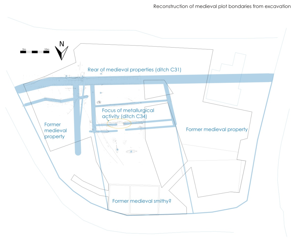
The earliest evidence from the excavation related to the organisation of medieval plots. A complex of c. 13th-century ditches stretching across the site divided it into at least three sub-rectangular plots, and further sub-divided these plots into distinct activity areas relating to the sloping nature of the land on the site. These plot boundary ditches were long-lived and showed evidence for frequent maintenance and re-cutting from the c. 13th century until the 19th century. The c. 13th century-date for the layout of properties on the site coincides approximately with the establishment of the borough, or lordly manor, of Termonfeckin, following the Anglo-Norman invasion. At this time Termonfeckin was an important town, containing a parish church and a palace for the Norman Archbishops, on the south bank of the river. The medieval houses were not identified, but these would have been situated on the roads to the north, south and west of the site, in the same position as the modern houses, which have removed all trace of their medieval predecessors. The backs of the plots were much better preserved. The archaeological remains here reflect the lives of medieval Termonfeckin’s inhabitants, who may have been immigrants of English, Scottish and Welsh origin.
18kg of ironworking slag and associated vitrified clay fragments were identified from medieval contexts during the excavation. The waste, which included multiple smithing hearth cakes, is characteristic of secondary blacksmithing activities. The type of clay bellows protectors appears to be perforated hearth wall but with unusual characteristics. Perforated hearth walls were the preferred bellows protectors of the Anglo-Norman smith, pointing to the ethnic origin of the smith (Rondelez pers. comm.) A radiocarbon date from a charred seed in the densest metallurgical waste context returned a calibrated date of 1224-1279 AD (95% probability; UBA-36838). The medieval smithy itself was not identified, however a 19th-century smithy was excavated on the roadside of the same medieval plot in 2009 (Giacometti 09E0258; excavations ref. 2009:581).
A notable feature of the metallurgical waste was the highly structured nature of its deposition. It was deposited outside of the actual smithy, around the entrance through a single ditch, which was well-defined between two rounded and deepened termini, with a concentration of Drogheda Ware pottery and animal bone. An adjacent feature, interpreted as contemporary, contained a concentrated deposit of decayed marine (mostly mussel) shell. This may be evidence for the careful and deliberate disposal of household and industrial waste within the site, reflecting a concern for the ‘right way to do things’ in the management of urban space.
Evidence for the cultivation, processing and storage of peas, wheat, oat and barley was documented, the butchery and cooking of animals and the eating of seafood including mussels. Evidence was also found for fruit orchards, tree-pruning, wood-collection for firewood and perhaps charcoal production, and wattle fencing. Many of the ceramic jugs and cooking pots dating broadly to the 13th century were manufactured in Drogheda, rather than in Termonfeckin, and reflect the strong connection between the two medieval centres.