2017:525 - ATHY: St Dominic’s Church, Kildare
County: Kildare
Site name: ATHY: St Dominic’s Church
Sites and Monuments Record No.: KD035-022
Licence number: 16E0550
Author: Padraig Clancy, CDHC
Author/Organisation Address: CDHC, Lynwood House, Ballinteer Road, Dublin 16
Site type: Structure
Period/Dating: Modern (AD 1750-AD 2000)
ITM: E 668055m, N 693780m
Latitude, Longitude (decimal degrees): 52.990426, -6.986357
Archaeological investigations were undertaken in the grounds of St Dominic’s Dominican Church in Athy, Co. Kildare in advance of the redevelopment of the disused church into a community library. The site is partially located within the zone of archaeological potential of the historic town of Athy (KD035-022). The distinctive Dominican Church, which was constructed in c. 1964, is centrally placed in the priory lands and the associated priory buildings lie to the south.
Seven test trenches were excavated along the line of proposed water, ESB and gas ducting corridors on 12-13 June 2017, while further monitoring took place in June. 170m of linear trenches were excavated to a depth of 0.3–0.75m. A tarmacadam surface lay on top of predominantly brown sandy silty build-up with stone cobbles noted in some of the trenches at a depth of 0.24m. The natural subsoil composed of gravel or of a mixture of sand, silt and gravel typically at a depth of 0.3–0.75m, although disturbance was noted as deep as 1.6m below ground level.
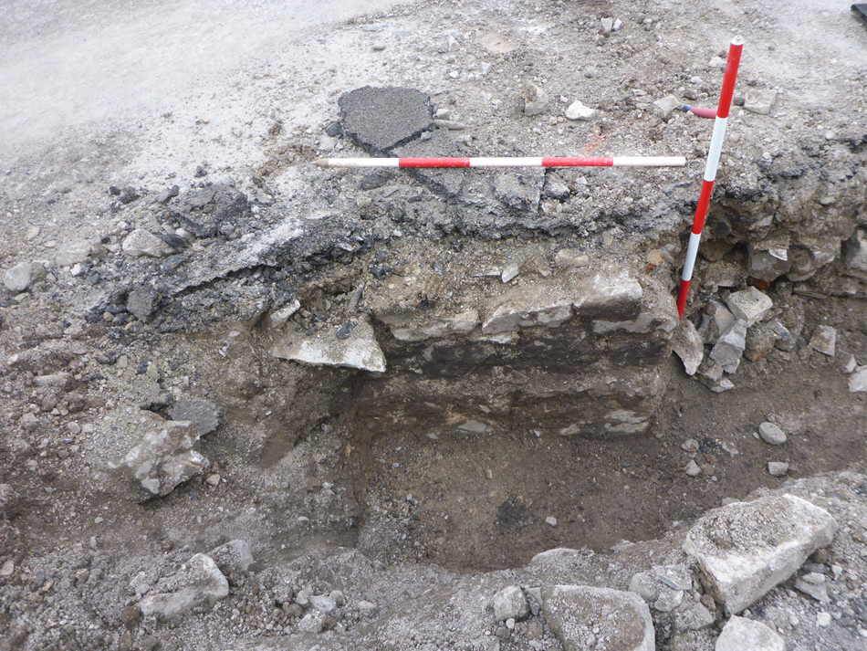
No evidence was found for any medieval or early post-medieval activity within the trenches and there is no suggestion that the line of any town defences passed through the site. Deposits of dark brown sandy silt containing shell, coal and red-brick fragments were found in Trench 4 on one side of a south-west by north-east wall 0.1m below ground level.
The wall was built from four even courses of roughly squared limestone blocks 0.7m in depth bonded with a grey sandy mortar. Typical blocks measured 0.4m by 0.2m. Two courses of stones overlay a stone footing which projected 0.1m from the wall face. The wall had a rubble limestone core and was 1.1m in thickness. It was built up against the natural compact sandy gravel. The wall was encountered at one point and its location and elevation was recorded. The electrical cable trench required a 0.75m-wide breach of this wall in order to lay the services.
The test trenches found a marked difference between the level of the ground in the western part of the site and the area closer to the church, where the wall in Trench 4 marked a significant drop and change in deposit type. This wall is consistent with an anomaly detected by a previous Ground Penetrating Radar survey and is also potentially aligned on a wall bounding a garden and entrance avenue to Riversdale house and subsequently the Dominican Church on the 1836 and 1872 Ordnance Survey maps. The wall was not present in Trench 5 which was heavily disturbed through the previous construction of a water main. The substantial rubble present in the upper deposits of Trench 6 is likely to represent the upper courses of the wall when it was demolished above ground level.
The current service trench layout will not further truncate the 18th/19th-century wall encountered in Trench 4. Any future works in the area should take account of the presence of demesne features associated with Riversdale house which have been shown to survive