2017:880 - Dunkellin Flood Relief Scheme (Killeely Beg, Castlegar, Dunkellin, Craughwell, Ballymore & Killora), Galway
County: Galway
Site name: Dunkellin Flood Relief Scheme (Killeely Beg, Castlegar, Dunkellin, Craughwell, Ballymore & Killora)
Sites and Monuments Record No.: N/A
Licence number: 16E0481
Author: Dominic Delany
Author/Organisation Address: Dominic Delany & Associates
Site type: Burial
Period/Dating: Late Medieval (AD 1100-AD 1599)
ITM: E 543652m, N 718404m
Latitude, Longitude (decimal degrees): 53.213064, -8.843614
The Dunkellin River Flood Relief Scheme extends from c.200m upstream of Craughwell Bridge, to c.400m downstream of Killeely Bridge near Kilcolgan in South County Galway. The works are divided into three areas: Craughwell village and environs in the east extent of the scheme, Rinn Bridge west of Rahasane Turlough in the centre, and Dunkellin Bridge to Killeely Bridge in the west extent of the scheme.
The 2017 programme of works included channel widening along the south bank of the river between Killeely Bridge and Dunkellin Bridge, a distance of approximately 1km. Most of this section of the river is a mid-19th-century cut carried out by the Commissioners of Public Works, when the river course west of Dunkellin Bridge was re-routed through a reclaimed turlough straddling the townlands of Kileely Beg and Castlegar. The riverbank corridor through the townlands of Kileely Beg, Castlegar and Dunkellin was topsoil-stripped between June and September 2017. Human remains were uncovered at Castlegar in late July, and subsequently excavated in early August. The site was located on a plateau of high ground in the south extent of Castlegar townland. The human remains consisted of the skeleton of a young adult male, truncated below the hips but otherwise well-preserved. The individual was buried supine and orientated west-east. The most conspicuous aspect of the skeleton was the contortion of the spine, which suggested the individual had suffered severe scoliosis. His deformity may account for the isolation of the burial but this is conjectural. Radiocarbon dating places the burial in the period spanning the mid-15th century to the first quarter of the 17th century.
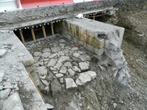
Works continued in the vicinity of Craughwell village in the east extent of the scheme. Topsoil strip was undertaken along the remaining section of the route of the proposed new bypass channel, revealing a stratigraphy that was generally similar to that recorded in 2016 (2016:879) but changed close to the riverbank where the subsoil was overlain by a thick, grey clayey silt riverine deposit. Works on the west side of the bypass bridge included excavations for channel deepening, and topsoil strip for an extension to the OPW site compound. A small plot of land at Killora to the west of the village was also topsoil-stripped, to serve as a site for stockpiling excavated soils. In August-September 2017, the existing Craughwell Bypass Bridge was removed. The remains of a previously-unrecorded stone bridge, tentatively dated to the late 18th century, had been identified within the two channels of the existing bypass bridge in 2016 (2016:879). An infilled third channel with slight remains of the spring of the stone arch including a couple of dressed arch ring stones, was uncovered to the north of the existing channels, on the west side of the bridge.
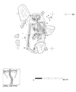
16E481: Single burial at Castlegar