2017:879 - St James' Campus, New Children's Hospital, Dublin 8, Dublin
County: Dublin
Site name: St James' Campus, New Children's Hospital, Dublin 8
Sites and Monuments Record No.: N/A
Licence number: 16E0408
Author: Thaddeus Breen; Shanarc Archaeology Ltd.
Author/Organisation Address: Unit 39a, Hebron Business Park, Hebron Road, Kilkenny
Site type: Test excavation
Period/Dating: Modern (AD 1750-AD 2000)
ITM: E 713341m, N 733532m
Latitude, Longitude (decimal degrees): 53.339868, -6.298031
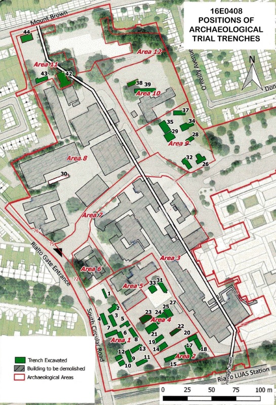
Test excavations were carried out on the site for the new Children’s Hospital at the western end of the campus of St James’s Hospital. The site comprised approximately 6.2 hectares; approximately one third of this was accessible for test trenching. From the late 1840s this part of the present campus had been the location of the Auxiliary Workhouse and later the Rialto Hospital, which was part of the St Kevin’s Hospital complex. Part of the northern end of the site extends as far as Mount Brown, sloping down into the valley of the Camac River.
Forty archaeological test trenches, the majority measuring 10m x 2m, were excavated. These were situated in open areas, such as car parks. The locations were chosen to investigate the sites of known buildings, to establish whether any burials had taken place in connection with the workhouse or hospital, and to examine the streetscape on Mount Brown, which is within the Zone of Archaeological Potential for Dublin City (RMP DU018-020) as it was one of the roads leading out of Dublin.
Foundations of a number of buildings were also found. The oldest was built between 1864 and 1875 and was part of the Auxiliary Workhouse. It was on the site of the current builders’ compound, south of the church. It was a long, narrow building, 5m wide, with limestone wall-footings on which the bases of brick walls survived in places. Two internal walls, running parallel to the outer walls, were probably supports for the floor. Pieces of wall plaster showed that the interior of the building was painted blue. A cobbled path ran alongside the building, and the floors of what were probably two entrance porches were found.
Foundations were also found of two early 20th-century buildings identified on a 1911 plan as the Male Lunatics’ Ward and the Female Consumptive Hospital. The former was immediately to the west of the building described above; the latter was south of the present-day Ambulance Centre. These had concrete wall-footings surmounted by brick. There were also concrete and breeze-block foundations of buildings constructed at various times after 1930. And, at Mount Brown, the remains of two semi-detached houses from c. 1900 were found at the top of the slope.
Layers of demolition rubble were found over and among the foundations of the demolished buildings, and also over much of the southern half of the site, where both this and clinker-rich material had been used to raise the ground level. Three backfilled parallel channels were found, running parallel to the boundary of the site. The innermost of these corresponds to the outlet from a reservoir shown on maps from 1843 to at least 1875, connecting it with the Grand Canal, and with a sluice gate at Rialto Bridge. Also in the southern half of the site, a series of land drains were found at a depth of 1.3m, consisting of narrow trenches filled with clinker and containing narrow ceramic pipes.
No human remains were found during these test excavations, however, as part of ancillary works associated with the installation of services, human remains were discovered south of Hospital 5, near the south-eastern corner of the hospital campus. This work was carried out under a separate licence (Excavation Licence No. 16E0595). The most plentiful find from the excavated trenches was pottery. Much of this was 19th-20th-century material, including a number of pieces marked ‘South Dublin Union’, but there were also the remains of 17-18th-century vessels, which pre-dated the workhouse, and two sherds from a 13th-century jug.
Archaeological remains were identified in two of the test trenches excavated (Trench 33 and Trench 44). In Test Trench 33, four pits were found, in each of which was a pair of horizontal planks which had originally supported an upright post. The features in Trench 33 were later excavated under a separate licence (Excavation Licence No. 16E0621).
At Mount Brown in Test Trench 44, at the base of the hill, fronting onto the street, underneath the foundations of two terraced houses demolished in the 1980s, which appear on cartographical evidence to have been built in the mid-19th century and enlarged a century later, were the remains of earlier foundations. They were associated with cobbled surfaces. Pottery found just above of the cobbles includes sherds of yellow sgraffito ware and brown slipware, both more common in the 17th and 18th centuries than later. A piece of late medieval pottery with internal and external green glaze was found nearby. These are not related directly to the cobbles, but are evidence of earlier activity in the area.
In addition to the test excavation, archaeological monitoring of groundworks took place in 25 places round the site. Most of these were small trenches and pits excavated to establish the location of various services. 17 of these were not excavated any deeper than the hardcore or sand underlying the paving. A further five were dug into the soil beneath, another was dug through a 20th-century dump. The remaining two uncovered the foundations of 19th-century buildings which could be identified from cartographic sources.
All spoil removed from archaeological test trenches and monitored works was scanned with a metal detector (Detection Licence No. 16R0166).