2017:680 - BANDON FLOOD RELIEF SCHEME, Cork
County: Cork
Site name: BANDON FLOOD RELIEF SCHEME
Sites and Monuments Record No.: CO110-019001
Licence number: E4481 (C578)
Author: Judith Carroll, Judith Carroll and Company
Author/Organisation Address: Ballybrack Road, Glencullen, Dublin 18
Site type: Weir - fishing, Town defences and Historic town
Period/Dating: Multi-period
ITM: E 549226m, N 555158m
Latitude, Longitude (decimal degrees): 51.746455, -8.735296
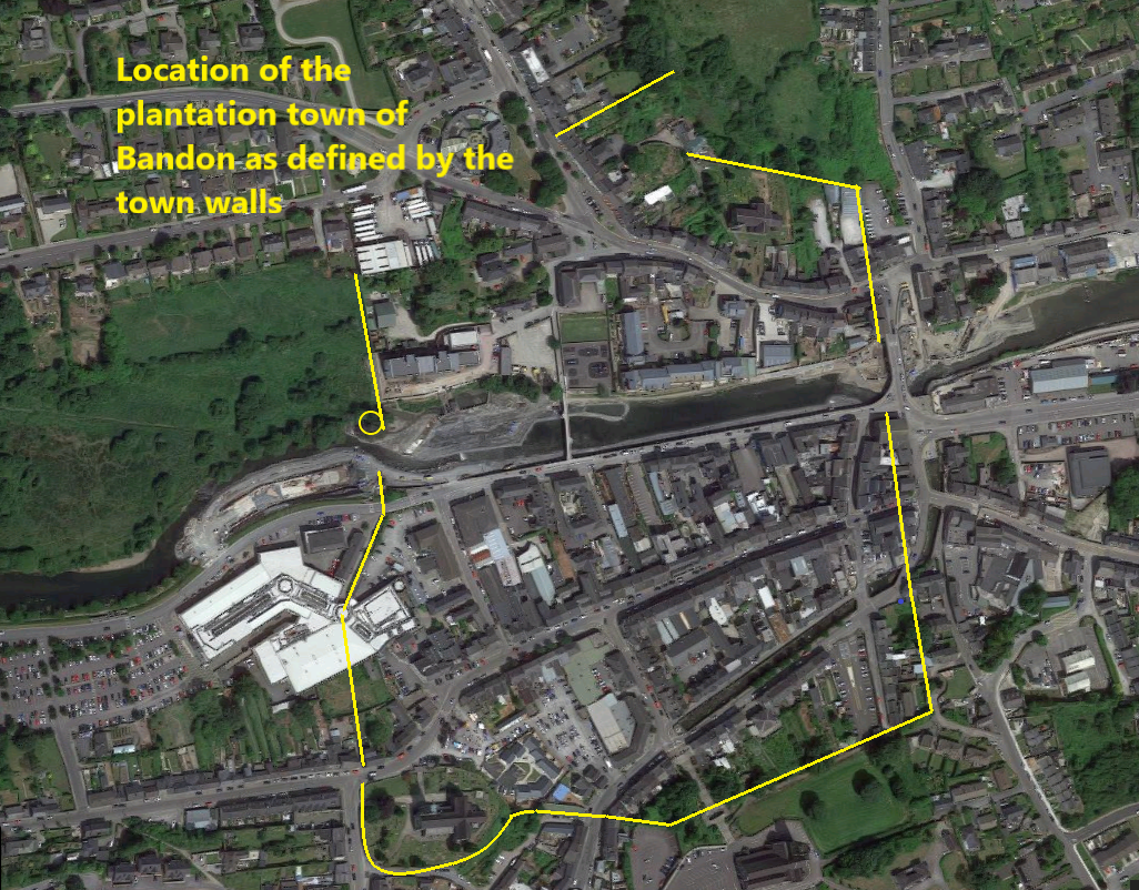
The scheme as a whole stretched 3.6km along the river, 110m west of the weir in Bandon Town to approximately 3.5km east of Bandon Bridge, while works on dry land and streams extended into several parts of the town and surrounding areas. There were two areas licensed for the scheme: that within the historic area of the plantation town of Bandon which was listed as a Zone of Archaeological Potential (ZAP) and the area outside the ZAP. This summary addresses monitoring and excavation work carried out within the ZAP under Ministerial Consent C578, E4881.
The work commenced in September 2016 and a summary of results has been given for that period in excavations.ie/report/2016/Cork/0025942, including a brief historical background. This year, works in the ZAP included monitoring of channel dredging, during which on-site visual inspection for any material (pottery, metalwork) to be found while the metal detector was also used when monitoring was taking place in-river. Monitoring of the removal of the 19th-century footbridge also took place and its removal at the north abutment revealed a 17th-century wall.
One of the main archaeological sites of importance in the ZAP area was Bandon Bridge where wooden stakes were visible under the piers and arches. In May testing and excavation was carried out at the same time as the initial site investigations and construction work in the dry river environment. This was followed by monitoring of all works under the bridge, followed by excavation under the arches including that of all wood features. Wood features were recorded in situ and analysed by our specialist, Dr. Ellen O Carroll. Testing under an extension of Ministerial Consent C578 revealed a new site to the west of the masonry structure. This was fully excavated between July and September 2017.
An exceptionally large piece of timber, over 6m in length, was found in July 2017 and identified as a probable bridge timber. Its position, 1.7m under one of the piers, established that it must predate the 1773 bridge. Dendrochronological and C14 dating through David Brown of Queen’s University Belfast, suggest strongly that it is 18th century in date.
On land, works in 2017 centred around drainage works on the east side of the Zone of Archaeological Potential. These were storm drains in two main areas: 1) Bridge Lane extending at its north end into/Pearse Street and South Main Street and 2) a storm drain extending from Brady’s Lane into Glasslyn Road and Kelleher’s Yard/Graham Norton Walk.
Bridge Lane was an area of particular interest. During trial testing for the drainage in 2007, wall structures had been noted by CRDS. Further testing took place by Tobar Archaeology in 2012 and walls with archaeological layers were noted. Work in Bridge Lane was monitored during March 2017 and archaeological layers and features were excavated.
Monitoring of SI pits and work on the storm drainage pipeline at Brady’s Lane Glasslinn Road and Kelleher’s Yard took place during 2017. During works in Kelleher’s Yard, a stone and brick wall was found and a proposal for resolution of this wall was approved in ext. 5 of Consent C578 in April 2017. Further SI pits were opened and monitored in September 2017 in Kelleher’s Yard. However, resolution of the wall was not carried out until January 2018.
A new fishpass through Bandon Weir, close to the line of the town wall, was one of the main archaeological concerns of the scheme and a number of mitigation strategies were put in place. The contractors’ works however did not take place on the weir/fishpass until 2018. During August 2017, trial testing was undertaken by Maurice Hurley in the dried river bed under the above licence and archaeological consent. A comprehensive report was produced by Maurice Hurley with many observations, but no new finds or features came to light during the archaeological testing of the gravels in the area between the town wall and tower directly to the west of the weir.