2017:679 - RATHNACALLY WIND FARM, Cork
County: Cork
Site name: RATHNACALLY WIND FARM
Sites and Monuments Record No.: N/A
Licence number: 17E0429
Author: Tony Bartlett, Archaeological Management Solutions Ltd.
Author/Organisation Address: Unit 1, Hector Street Mills, Kilrush, Co. Clare
Site type: Excavation - miscellaneous
Period/Dating: Multi-period
ITM: E 552211m, N 619871m
Latitude, Longitude (decimal degrees): 52.328375, -8.701113
Monitoring and excavations were undertaken for the construction of Rathnacally Wind Farm, Charleville, Co. Cork. A total of ten areas (Areas A–J) of archaeological activity were uncovered during topsoil stripping of access roads, turbine pads, hardstands, substation and underground cable ducting. All remains from nine of the areas of archaeology (Areas A, B, D, E, F, G, H, I and J) were fully excavated. The remains at Area C were preserved in situ beneath a floating road construction after consultation with the National Monuments Service. Apart from Area J, which was located in the townland of Garrynagranoge, all other areas were located in the townland of Rathnacally.
Area A was revealed within the main access road and comprised a single cereal-drying kiln. It was figure-of-eight shaped and measured 2.3m by 1.1m by 0.54m in depth and contained three fills. The level of the base of the kiln was stepped in the south-west, becoming deeper in the north-east where intense in-situ burning was present.
Area B consisted of a single cereal-drying kiln. It was figure-of-eight shaped and extended beyond the limit of excavation outside the cutting of the main access road. The maximum exposed dimensions of the kiln were 1.7m by 1.03m by 0.43m in depth and it contained two fills. The level of the base of the kiln was slightly stepped in the south-west, becoming deeper in the north-east where intense in-situ burning was present.
Area C comprised a series of pits, post- and stake-holes revealed within an area measuring 40m by 12m spanning the width of the main access road. Two post-holes were half-sectioned to obtain dating material and assess the nature of the deposits. A flint flake was recovered from one of the sectioned post-holes. All of the features were photographed, recorded and surveyed in plan prior to reburial.
Area D comprised two small charcoal-rich pits. One of the pits produced 25 sherds of prehistoric pottery.
Area E comprised a portion of a low burnt mound identified within an internal access road adjacent to turbine T2. It extended beyond the limit of excavation of the access track to the west and north and had maximum exposed dimensions of 13.35m by 10.45m by 0.35m in thickness. The mound was truncated by a post-medieval agricultural enclosure ditch, which was in turn truncated in recent times by the excavation of a geotechnical test pit.
A total of eight subsoil-cut features comprising a trough and seven pits were revealed beneath the mound. The trough was sub-rectangular in plan and measured 1.44m by 1.19m by 0.48m in depth and contained a single fill. It had seven stake-holes cut into the base along its northern and southern interior edge, indicating the former presence of upright wooden stakes which may have supported a timber lining. A saddle quern was present in the trough, placed on its long edge against the north-east end of the cut.
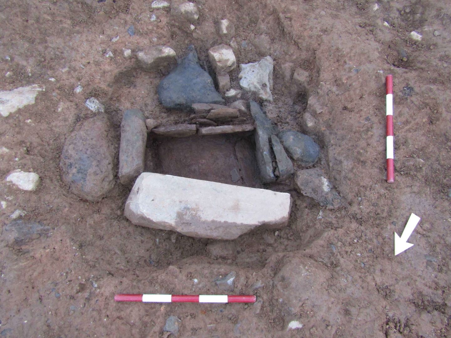
Area F was identified within the area of turbine T1 and the adjacent hardstand and substation. Area F comprised a roundhouse, a ring-ditch and a short cist. Several pits, post- and stake-holes were recorded in association with the roundhouse and surrounds.
The roundhouse was delineated by ten post-holes and had a diameter of 8.25m, with a possible entrance identified in the south. The ring-ditch was represented by a penannular ditch measuring a maximum 0.5m in width by 0.35m in depth. The ring-ditch measured 3.5m by 3.65m in plan, with a 0.45m gap in the south-east. The cist comprised a rectangular stone-lined box, constructed of four side stones and two floor slabs. The capstone had been disturbed and only a few fragments survived. The internal dimensions of the cist were 0.5m by 0.28m by 0.25m in depth, and it contained two distinct deposits of cremated human remains.
Several sherds of prehistoric pottery and lithic artefacts were recovered from the excavation of Area F, including two sherds of decorated pottery from the cist.
Area G was identified within the hardstand for turbine T2 and comprised an earth-cut well. It was sub-oval in plan and measured 2.72m by 2.04m by 0.72m in depth. A stepped area forming a working platform was revealed near the base of the feature. A large oak beam was found along the full length of the cut of the well to act as a retaining construction element for the working platform. The beam was supported by two wooden stakes driven at an angle into the side of the well beneath the beam.
Area H was identified within the deposition area to the immediate north of the site compound and comprised a single small pit containing charcoal. No artefacts were recovered from Area H.
Area I was identified in an extension to the main access road adjacent to the entrance to the wind farm, and consisted of a series of pits, post-holes, hearths and stake-holes. Nine of the stake-holes and two post-holes indicated a possible trapezoidal-shaped structure measuring 3.2m by 3.15m. No artefacts were recovered from Area I.
Area J was identified in a trench cutting for the external underground electricity cable ducting. It comprised a close grouping of three shallow pits, one of which produced sherds of possible prehistoric pottery, and a cremation pit 50m to the east. The cremation pit measured 0.34m by 0.32m by 0.13m in depth and contained a single fill with frequent charcoal and moderate cremated bone.