2017:492 - LANDS TO THE NW OF RASHARKIN, Antrim
County: Antrim
Site name: LANDS TO THE NW OF RASHARKIN
Sites and Monuments Record No.: N/A
Licence number: AE/16/188
Author: Dermot Redmond, Gahan & Long
Author/Organisation Address: 7-9 Castlereagh Street, Belfast BT5 4NE
Site type: House - Bronze Age
Period/Dating: Bronze Age (2200 BC-801 BC)
ITM: E 695634m, N 914192m
Latitude, Longitude (decimal degrees): 54.966196, -6.506504
An archaeological evaluation was carried out prior to the construction of an 18 MW Photovoltaic Solar Farm on lands to the NW of Rasharkin, Co. Antrim. The development is divided into two distinct areas, one of approximately 71 acres and the other of 19 acres.
The first phase of testing consisted of the random trench layout across the area of the site where underlying geology has masked the geophysics results. A total of 119 trenches were excavated all of which were on average 1.8m wide. The second phase of testing consisted of the excavation of test trenches targeted above those anomalies identified within the geophysical survey. A total of 48 targeted test trenches were excavated. The depths of the trenches were generally shallow, usually no more than 0.3m in depth. All of the trenches were excavated through topsoil. The subsoil was predominately a yellowish grey or orangey sand with inclusions of small stones.
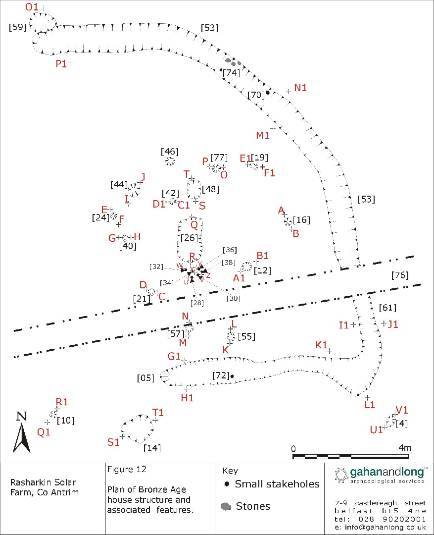
During the course of monitoring, a number of deposits and features of archaeological potential were identified. The test trench 1506 which contained potential archaeological features was extended under strict archaeological supervision, and the features identified were excavated and recorded. The main feature uncovered was a single enclosure house structure enclosed by a linear and curvilinear that formed a penannular shape, open at the west. These features were dated by the artefacts which they contained to the Bronze Age period, with C14 radiocarbon dates placing them.
The house structure identified on site at Rasharkin consisted of eight postholes forming a sub-circular shape surrounded by two gullies that form a rough penannular shape. There were 2 internal postholes recorded within the perimeter of the house structure which formed a rough line on an NE-SW axis. It is doubtful that these postholes fulfilled a structural role within the house as they were quite ephemeral and would not have been load bearing. The postholes may also have been subjected to a degree of truncation. Between these two postholes lay a hearth and another internal pit. A modern field drain extended NW-SE across the SE edge of the house structure may have destroyed several features
Eight post holes [16], [21], [24], [40], [44], [55], [57], [77] form a circle around a hearth, [26] which has an adjacent pit, [47] 0.7m to its north and 6 stake holes [28], [30], [32], [34], [36] [38] 0.3 to its south. On average a distance of 1.5m separate the post holes from the hearth, with a total diameter of the structure roughly 5.5m. It is possible that field drain [76] that cuts [53] has destroyed at least one possible posthole. Only two sherds of pottery were found within the structure, within posthole [44]. A flint scraper was also found in posthole [40].The morphology of the house, and the finds of Bronze Age pottery, would almost certainly point to a Bronze Age date.
Two linear slots [5] and [53] form a penannular shape, open at the west around the structure. Slot [5] is fairly straight, with [53] having a more pronounced curve. Slot [53] is cut by a modern field drain [76] running NE-SW across the site. A new number was given to this slot [61]. Slot [61] cuts slot [5]. Two stake holes [70] and [74] were situated within [53] and one in [5], [.72]. Wood was recovered from stake hole [74]. Slot [53] had many stones of all sizes within its upper fill, with a lower charcoal rich fill beneath. Slot [5] also had stones present, (though smaller in size and quantity) with large amounts of charcoal and evidence of burning (burnt stones, discolored clay, charcoal rich etc) throughout. 11 sherds of Bronze Age pottery were present within [53], 9 from its top fill [54] and 2 from its middle fill [62]. An analysis of the pottery would indicate that they are of Bronze Age in date. A probable hammer stone was also recovered from [53], just above stake hole [70]. 7 sherds of pottery were present in slot [5], also from the lower fill. An analysis of the pottery would indicate that they are of Bronze Age in date and were probably cooking vessels. 7 lithic pieces were also present. 1 is a flint blade, 1 was a discarded flint core, and 3 pieces were burnt flint debitage and 2 possible scrapers. Curvilinear [53] was probably a drainage surrounding the interior structure. Due to the more complex nature of its fills and the large amounts of charcoal and evidence of burning within [5], it may have had another purpose, possibly as a wind break, before being reused as a drainage gully in conjunction with [53].
No other archaeological feature was uncovered during the course of the evaluation.