2017:476 - Royal Exchange, North Street, Belfast, Antrim
County: Antrim
Site name: Royal Exchange, North Street, Belfast
Sites and Monuments Record No.: N/A
Licence number: AE/17/148
Author: Audrey Gahan, Gahan & Long Ltd
Author/Organisation Address: 7-9 Castlereagh Street, Belfast BT5 4NE
Site type: 17th- /18th-century tannery and settlement
Period/Dating: —
ITM: E 733715m, N 874505m
Latitude, Longitude (decimal degrees): 54.601094, -5.930467
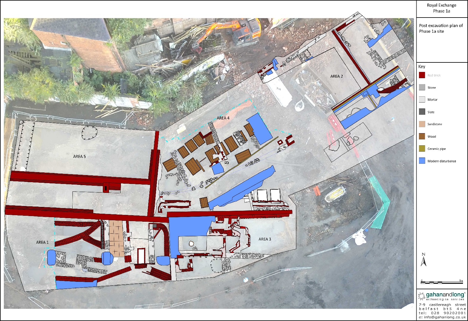
An archaeological evaluation was carried out prior to the construction of Phase 1 of the Royal Exchange Project, North Street, Belfast. A series of test trenches across the development area identified archaeological strata extending across the entire site. All identified features and deposits were fully excavated. The excavation was divided into 5 areas.
Area 1 was located in the west-south-west area of the site. Naturally occurring subsoil was identified as a bluish grey – light golden brown sleech. It was overlain by a dark black, soft humic silty layer, which in turn was overlain by a mid to dark brown silty clay. This underlay a sealing layer of orangey pink Keuper Marl which extended across the area. Analysis of the pottery retrieved from these layers indicated sherds dating from the 17th and 18th centuries, including imported German and Dutch wares. The pottery retrieved from the overlying layer was in general dateable to the 18th century. The Keuper Marl layer was artefactually sterile, probably indicative of its use as a possible damp-proofing layer.
A number of walls were identified, some made of stone but mostly made of red bricks and appearing to date from 17th – 18th centuries.
While flooding was an issue during excavation, the identification of a number of drains within the relatively small area suggests that inundation was also historically an issue. The drains were constructed of red bricks bonded with an off-white lime mortar and two were vaulted. The area also contained a rectangular brick-lined pit, with straight sides and red brick tiles on the bottom. It was filled with dumped red brick and mortar and covered by ceramic tiles.
Area 2 was located towards the North Street frontage area and contained two boreholes which were the subject to ongoing monitoring and could therefore not be removed. Naturally occurring subsoil in this area consisted of a mid-bluish grey – light brown sleech and was overlain by several deposits of a soft black silty clay containing abundant amounts of artefacts. Pottery from this layer included local wares as well as Bristol/Staffordshire and North Devon wares which again indicate a 17th-18th-century date. This layer underlay a very friable, dark orange – brown silty sandy clay deposit containing abundant amounts of rubble. The earliest features identified within this area consisted of several stone and mortar walls and pits, which were cut into subsoil. An inspection of the early maps of Belfast shows that properties would have fronted onto North Street from at least the mid-17th century and their main areas would have been under the footpath beyond the limit of excavation. Therefore some of the stone walls are likely to represent the back yard boundaries of these properties.
Overlying the 17th-18th-century activity were a series of modern 19th-century red brick walls and service trenches. One prominent red brick wall extended north-west/south-east across the area and another, adjacent to the latter but not joined to it, was located at its right angle.
Area 3 was located to the east of Area 1 and was subject to a large amount of modern disturbance with reinforced concrete dramatically reducing the area of excavation. The earliest features identified within this area were several walls and a pit, all also most likely to date to the 17th-18th century, and constructed directly onto subsoil. A wooden barrel, measuring 0.58m in diameter, was located within the south-west portion of this area. No dating material was identified in the fill as it could not be excavated but the barrel is set into naturally occurring subsoil and is likely to date to the 17th – 18th century. The remaining features identified within Area 3 were all of modern date, i.e. later 19th to 20th century, and consisted of red brick walls, two possible coal chutes and a chimney.
Area 4 represented the central portion of the excavation where 15 tanning pits, positioned across the northern section, were found. The majority of the tanning pits were constructed of wooden planks joined together by wooden dowels. The base planks appear to have been held together by a smaller base plate. This method of construction is similar to that of a series of 18th-century tanning pits excavated by the author at Stone Row, Coleraine and the pits are likely to be of comparable date. The skeletal material was dominated by cattle horn-cores, which suggest that the tanners using the Royal Exchange site may have only sold on the sheaths of the horns to the horn-workers.
Area 5 was located in the north-west corner of the site. A small number of subsoil-cut features were identified within this area, including two pits and a ditch. Pottery retrieved from the fills was consistent with a 17th- to 18th-century date.
To resume, the main activity within the site consisted of a tannery. Further material uncovered verified the boundaries shown in some early maps of Belfast and identified probable house structures fronting onto North Street. It was also possible to identify the re-use of walling materials both as re-builds and the use of earlier stone walls as the foundations for modern red-brick structures.
Finds included pottery, leather, clay-pipes, and glass. While a wide range of ceramics was recovered, the assemblage is relatively small (742 sherds) in comparison to other assemblages in Belfast. However, despite this, wares from a range of countries and unusual forms were identified which indicate that pottery of high value, indicative of a particular social standing, were in use. A large amount of skeletal material dominated by cattle horn-cores within Areas 1 and 4, with a NISP of 703, was also recovered.

