2016:869 - VARTRY: Knockfadda/Callowhill Upper, Wicklow
County: Wicklow
Site name: VARTRY: Knockfadda/Callowhill Upper
Sites and Monuments Record No.: N/A
Licence number: 16E0208
Author: Thaddeus Breen; Shanarc Archaeology Ltd.
Author/Organisation Address: Unit 39a, Hebron Business Park, Hebron Road, Kilkenny
Site type: Burnt spread
Period/Dating: Undetermined
ITM: E 723441m, N 702304m
Latitude, Longitude (decimal degrees): 53.057104, -6.158514
Archaeological test trenching was undertaken in the townlands of Callowhill Upper and Knockfadda, Vartry, County Wicklow between 11 and 16 May 2016. Works related to a proposed Irish Water pipeline to run from Vartry Water Treatment Plant to a new connection point with the existing Callowhill to Stillorgan pipeline within the townlands of Callowhill Upper, Corsillagh and Knockfadda in Co. Wicklow. The proposed pipeline is approximately 4.3km in length and follows a route traversing pasture farmland, woodland, areas of blanket bog and road surfaces/areas of hard standing.
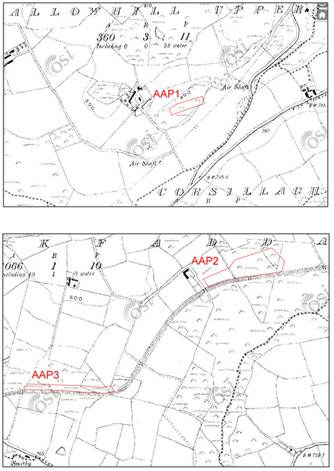
Archaeological testing took place in three areas of archaeological potential (AAP1-3) previously identified on the site of the proposed Vartry Water Supply scheme redevelopment.
Three trenches were excavated at Site AAP1, a gorse-covered hill with rock outcrops in the middle of a field; these measured 1.5m in width, 18-26m in length and up to 0.8m in depth. The most noticeable features here, obvious even before the trenches were dug, were a low bank and shallow internal ditch forming the western boundary of the hill. On excavation, the bank proved to be composed of a rather loose deposit of burnt stone in a matrix of black soil. This extended on either side of the bank, which was about 1m thick, whereas the burnt spread was 4m wide, and the ditch seemed to have been dug into it. No artefacts were found.
Site AAP2 was 874m to the west of Site AAP1. It was situated on level ground alongside a watercourse constructed in connection with the Vartry Waterworks in the 19th century. This was the only one of the sites of archaeological potential which was in close proximity to a monument: a low earthen mound, WI018-055, was 20m from the proposed pipeline. Three trenches were excavated at AAP2, these measured 1.5m in width, 20-60m in length and 0.5m in depth. The general stratigraphy comprised mid-brown topsoil overlying light whitish clay and areas of dark brown peat. No archaeology was found during testing.
Site AAP3 was 600m to the south-west of Site AAP2. It was similar in type to AAP2, in that it was a marshy area with rushes, alongside the watercourse. It was, however, much wetter, with a stream flowing through it. Due to the wet nature of the site only a single test trench could be excavated; the trench was 15m long, and was excavated to a depth of 0.35–0.5cm. The upper layer was peat, 0.15–0.2m deep. This overlay a homogenous deposit of blue marl. No archaeology was found during testing.