2016:866 - CASHEL: Cashel Palace Hotel, Tipperary
County: Tipperary
Site name: CASHEL: Cashel Palace Hotel
Sites and Monuments Record No.: TS061-025011; TS061-025-; TS061-025023- (Town Defences)
Licence number: Ministerial Consent E4750; C758
Author: Joanne Hughes, C/O CRDS Ltd.
Author/Organisation Address: 2 Grosvenor Terrace, Monkstown, Co. Dublin
Site type: Medieval to modern
Period/Dating: Multi-period
ITM: E 607460m, N 640729m
Latitude, Longitude (decimal degrees): 52.517882, -7.890085
Archaeological testing works were conducted between 5 August and 5 September 2016. A total of 13 of 17 test trenches (Trench numbers 1, 2, 3, 4, 5, 6, 7, 8, 9, 13, 15, 16 and 17) set out in the initial excavation strategy under Ministerial Consent C758, E4750 at the Cashel Palace Hotel, Cashel, Co. Tipperary were excavated. Four of the proposed trenches were not excavated due to the presence of an unstable site boundary wall (Trenches 10, 11 and 12), and due to the presence of mature trees which prohibited access with machines (Trench 14).
Archaeological features were present in all trenches; frequently these were extensive and very well-preserved. Based on artefactual and stratigraphic evidence it seems that four main phases of activity are represented, the earliest (Phase 1) medieval phase likely being 12th–13th century, the second phase being 13th/14th century in date. The medieval activity in most areas (most notably in Areas F & E) was sealed by a thick deposit of introduced clay which probably relates to the construction of the Archbishop’s Palace and laying out of pleasure gardens for same in the early 18th century (Phase 3). The final phase of activity is 19th century and later in date (Phase 4).
AREA A – Trenches 1, 2 and 3
These trenches were located to the front of the Cashel Palace building, with Trench 1 being located closest to the street front and Trench 3 closest to the main Cashel Palace Hotel building. Medieval deposits (Phase 2?) were encountered in Trench 1 at approximately 1.4m below present ground level and were represented by a thick deposit of charcoal-rich burnt layer. A sondage through the western side of this deposit showed it to be approximately 0.2m deep, and overlying the natural subsoil. It is unclear whether or not this deposit represents the remains of a burnt building; 17th-century sources refer to the burning of the town in 1654. Medieval deposits in this trench were not more than 0.4m deep, and the uppermost medieval level was represented by the remains of a possible wall or wall footings seen in the northern section face of the trench. Above this possible wall were successive layers of post-medieval deposits, surfaces, cobbled layers and fill layers which were approximately 1m deep at maximum (Phase 3 & Phase 4).
In Trench 2 probable medieval deposits were encountered at c.1.2m below present ground level and comprised a possible stone-tiled floor, metalled floor surfaces and cobbled layer (Phase 2?). The medieval deposits were not bottomed, and natural subsoil was not encountered in this trench. As in Trench 3, successive layers of yard cobbling and post-medieval fill deposits (Phases 3 & 4) were identified and survived below present ground level to approximately 1m deep above the medieval layers.
Trench 3 was excavated to a depth of 1.4m at the southern portion of the trench, and to the top of a cobbled layer which closely resembled the lowest level of cobbles identified in Trench 4 to the east (Area B). All of the deposits encountered above these cobbles were clearly post-medieval in date. This cobbled layer would appear to represent the old ground level which is contemporary with the construction of the main Cashel Palace building in the early 18th century. Alternatively, these cobbles could represent the floor of the earlier Cashel Palace building constructed by Archbishop Miler McGrath in the 17th century.
AREA B—Trenches 4 and 7
Located to the east of the main Palace buildings, the earliest phase identified is probably 14th century in date (Phase 2; based on ceramic assemblage) and is represented by medieval pits and old ground surfaces in Trench 4. In Trench 7 the structural remains of ancillary service buildings and offices (Phase 3) depicted on 19th-century mapping were identified, with one of these walls possibly relating to an earlier (undated post-medieval) building. Three successive layers of cobbled yard surfaces with associated mortar bedding layers were identified in Trench 4, with the earliest layer of cobbles sealing all medieval activity. Medieval deposits were identified in the south-eastern corner of Trench 4 where they were cut through by a possible stone-lined well. The archaeological investigations in Trench 4 did not reach the base of medieval layers because of the unstable nature of the baulks and ingress of water in the base of the trench.
AREA C—Trenches 5 and 6
These two trenches were located to the rear of Mikey Ryan’s pub, adjoining the main Cashel Palace Hotel property, and in an area formerly known as Lyster’s Lane (shown on 1840 1st Edition OS and subsequent mapping). A number of post-medieval buildings were located along this laneway and the intention with these trenches was to investigate the potential for post-medieval and medieval land use, and the potential for earlier structures.
In Trench 05 medieval deposits (Phase 2) were encountered at 2m below present ground level and comprised probable pits. These were not excavated due to the depth of the trench and for health and safety concerns. However, environmental samples were recovered from these features, and preliminary processing has recovered a medieval ceramic sherd, probable iron nail as well as animal bones. A thick deposit of garden soil (Phase 3) had sealed the medieval deposits and successive layers of post-medieval floor surfaces as well as a substantial east-west orientated limestone masonry wall were noted in this trench. The post-medieval wall showed clear evidence for a red-brick bow-fronted window preserved at its uppermost surviving course at c.0.2m below present ground level.
In Trench 06 the earliest deposits encountered (at c. 1.6m below present ground level) comprised old ground surfaces (2 distinct layers) which are most likely post-medieval (Phase 3) in date. These deposits had been cut by post-medieval pits. The pits and old ground surfaces had been in turn sealed by a thick deposit of introduced clay marl, and through which a number of furrow-like features were identified. These features are interpreted as being part of the workings of a possible kiln flue or furnace, possibly associated with 18th-century hot-houses as the fill in both comprised clinkers and coal with tap-slag fragments being identified throughout. It is likely that the introduced deposit of clay marl was used as a thermostatically stable material on/in which a furnace/kiln could have successfully operated.
AREA E—Trenches 8 and 9 & AREA F—Trenches 13, 15, 16 and 17
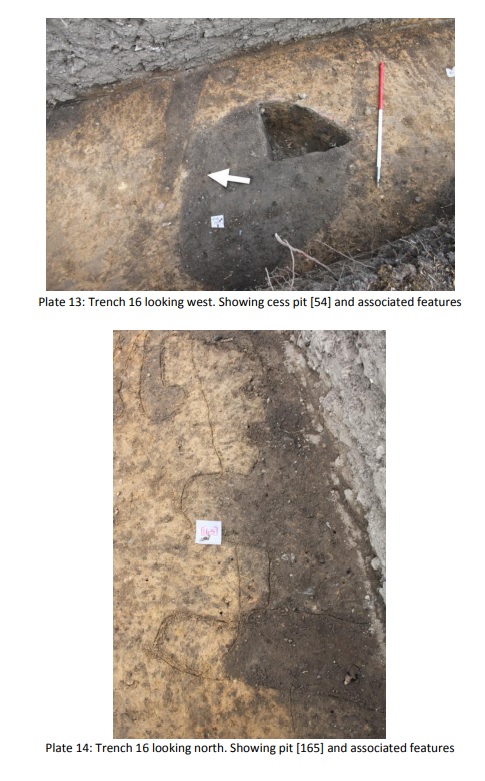
The archaeological features identified in Area F in Trenches 17 and 16 collectively suggest the presence of a 12th-13th-century settlement located at the north side of the 14th-century Town Wall on the lower slopes of The Rock of Cashel, and are represented by the structural remains of houses (beam slots, post-holes, stake-holes) with cess pits, rubbish pits etc. identified. Evidence for a roughly east-west orientated ditch with an associated bank on its southern side tentatively appears to date to this phase of activity and most likely relates to but does not delineate the 12th-13th-century settlement.
The second and most substantial phase of medieval activity in Areas F and E (Trenches 17, 16, 15, 13, 9 and 8) appears to relate to the laying out of new plots and associated structures immediately following the construction of the Town Wall in AD 1319. The evidence for this later settlement is similarly represented in the form of roughly north-south orientated plot boundary ditches with houses, cobbled possible yard surface, a well, cess pits, rubbish pits and post-and-wattle fences identified.
The east-west orientated 12th-13th-century ditch was backfilled in the 14th century and was re-cut shortly after backfilling. Significantly, the settlement evidence for this phase was found on both the north and south sides of the Town Wall and sheds light on heretofore unknown contemporaneous intra and extra-mural 14th century-settlement at this part of Cashel.
The artefactual evidence recovered points towards considerable craft and industrial activity taking place in the medieval settlements with significant evidence for antler, bone and horn working identified. Metal working is represented in the form of smithing hearth bases and slag associated with the 14th-century activity. A fragment of non-metallic slag may relate to glass working on the site. Approximately 100 sherds of medieval ceramics were recovered and while the majority of these appear to be Cashel-type ware there are also sherds of Saintonge and most likely Bristol wares represented in the assemblage. Two metal pins were recovered, one of which is tentatively dated to the 12th-13th century and the second relating to the 14th-century phase of activity (based on comparisons with material from the Waterford excavations).
The third main phase of activity identified across Area F is likely to be 18th century in date and most likely relates to the landscaping of gardens to the rear of the Cashel Palace built in 1728. The evidence for this activity is in the form of a thick (up to 1.2m deep) introduced layer of clay which seals all of the earlier medieval activity and appears to be a levelling layer on which the pleasure gardens for the Archbishop’s Palace were set out. Two walls, one north-south orientated and a contemporary and associated east-west wall were identified in Trench 16 and would appear to relate to the original layout of the Palace Gardens. These walls are not represented on the OS 1st edition (1840) or later mapping for the Cashel Palace. Garden paths, probable tree and shrub boles and rubbish pits associated with this phase were also identified consistently across Areas F & E to the rear of the extant Palace building. The fourth and final phase of activity from the 19th century onwards is represented in rubbish pits and rubbish dumps cut into the top of the earlier 18th-century levelling layer.
In addition to the physical archaeological remains uncovered during the testing work a large number of architectural fragments identified in the gardens of the Cashel Palace and incorporated in the structural fabric of the extant Palace walls strongly suggest the presence of an earlier substantial 17th-century building lying as yet undetected in the grounds of the Cashel Palace Hotel.
The archaeological investigations provided an insight into the development of the medieval urban centre of Cashel via a transect from the centre of the 14th-century walled town at Main Street, through to the lower slopes of The Rock of Cashel to the north. The testing strategy allowed for the investigation of the relationship between The Rock and the town for the first time. As the area of investigation was enclosed and relatively undeveloped since the early 18th century the potential for undisturbed medieval (and potentially earlier) activity was clear from the outset.