2016:860 - NAVAN: Old Kilcarn Bridge, Meath
County: Meath
Site name: NAVAN: Old Kilcarn Bridge
Sites and Monuments Record No.: ME025-039
Licence number: C691: E004769
Author: Niall Roycroft
Author/Organisation Address: c/o Meath County Council
Site type: Excavation - miscellaneous
Period/Dating: Modern (AD 1750-AD 2000)
ITM: E 688465m, N 765561m
Latitude, Longitude (decimal degrees): 53.632368, -6.662428
These works were monitored by ADCO Ltd. This summary is provided by Niall Roycroft who was the Meath County Council Archaeologist for the scheme. This summary is an interim statement pending the final report and should be considered a draft statement only.
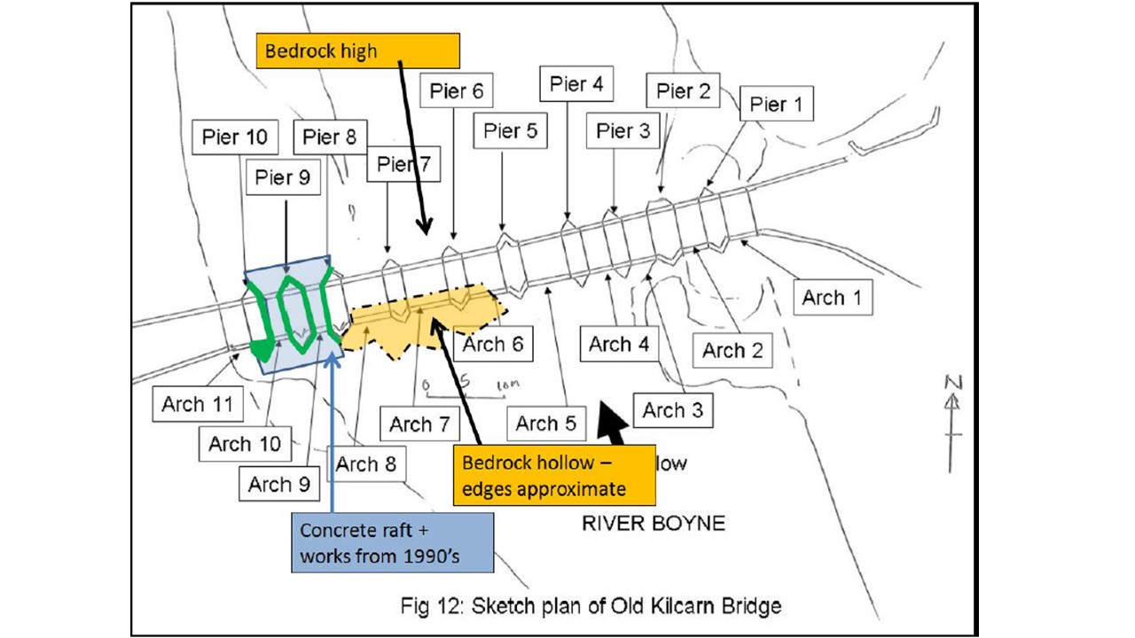
The original Kilcarn Bridge was 13 arches—all of the smaller, 3.2m wide type as seen in Arches 1, 2, 3, 4, 9, 10, 11 (from east) with piers 2.5–2.6m wide (except Pier 2 from east, which is 6m wide and probably sat on an in-channel island). The arch profiles are not 12th-14th-century type (i.e. slightly pointed as seen at Slane or Babes’ Bridge) but of a rounded, c. 15th- but more probably 16th-century type. Wickerwork arch centring marks are visible in Arches 1–3 and perhaps Arch 4 from the east.
At some stage, probably in the 17th century, the central four arches (5, 6, 7, 8 from east) were built to replace an original length of six, smaller arches. Pier 6 is common to both schemes and some of the partly demolished earlier piers were retained to act as permanent scaffolding for the larger arch constructions. No wickerwork centring is visible under the larger arches.
With the remodelling of the arch profiles the bridge deck must have been remodelled from a flat deck (as at e.g. Slane) to an arched deck (as at present), in order that the deck could clear the new, larger arches. Remodelling the bridge deck also meant remodelling the bridge parapets. All this is probably 17th century in date.
The Downstream (north) face of the bridge has been remodelled and the entire parapet has been replaced since the original form. It is quite possible there were some or many more pedestrian refuges in the original build. The downward pointing triangular tops to the cutwaters probably date from the 17th-century parapet remodelling (which is why they are an unusual feature on Irish bridges). One pedestrian refuge was rebuilt on the northern side on Pier 5. This refuge has curved approaches as opposed to the later ones on the south side which all have angular approaches. The parapet capping stones on the north side have all been relaid fairly recently and the iron ties are pointing in all directions.
The whole bridge was widened on the south (upstream) side around 1700-1750 (probably 1729/30 to coincide with Dublin Road Turnpike). This south build included pedestrian refuges above all cutwaters. Three of these refuges have since been removed – all due to low cost repairs to structural damage of the parapet and/or south bridge face.
Arches 1+2 from the east were used as a tailrace for Kilcarn Mill.
There were many tree-covered islands in the river until they, and the mill tailraces were cleared between 1995 and 2000. With the removal of the islands there was intense scouring under the central four arches 5, 6, 7 and 8.
Following the 1990’s collapse around Arch 11, scour collars were added to two and a half piers (Piers 8, 9, 10) on the west side and these are in good condition. The Boyne Channel upstream of Kilcarn Bridge has been encroached again since 1995.
Two guns were found in the River, adjacent to the eastern bank. Niall Brady from ADCO was at the scene, but the Gardaí took both the guns away. The rifle appears to be a Martini-Henry of c. 1900 of the sort used in 1916 Rising with the stock rotted away (and barrel bent). These guns are of a type sometimes found hidden in the countryside from Easter Rising, War of Independence, Civil War, i.e. 1916–1923 period. But the one at Kilcarn could also have been lost by a member of the Royal Irish Constabulary, who were issued with these rifles up to 1905.
The other gun was an Agram 2000 sub-machine gun made in 1990’s Croatia and of a type ‘often used by criminals’ according to the Wikipedia article. Both guns were found on the riverbed in an area that was dredged 1995–2000 so have probably been moved to that spot by recent water action from upstream somewhere.
Other finds included: musket balls (some had been flattened from impact, perhaps with the Bridge); very many modern bullets (often live, rifle, handgun, shotgun and .22, possibly confiscated and disposed of into the river); the two guns mentioned above; several shotgun barrels (sometimes bent out of shape); a mid-20th century Mills Bomb hand grenade (the base plug, which gave access to the explosive filling, had been removed, so it appears to have been decommissioned); many 20th-century small denomination coins; several Ganesh Hindu Elephant earth gods (associated with Hindu water blessing prayers); a worked stone architectural fragment; shop and domestic weights; ‘Fouled Anchor’ Navy belt buckle cover officer class; some apparent trade tokens pottery; a watch; a clock; a man’s wedding ring; several large knives; a gilded triangular plaque; Victorian brooch-style ornaments; iron sickles; several mobile phones; horseshoes; a traction engine wheel; fishing weights and several small pick-axe heads.

