2016 - L1607 Road improvements inside the Core Area to the Brú na Bóinne UNESCO World Heritage Site in MAY 2016, Meath
County: Meath
Site name: L1607 Road improvements inside the Core Area to the Brú na Bóinne UNESCO World Heritage Site in MAY 2016
Sites and Monuments Record No.: N A
Licence number: Unlicensed
Author: Niall Roycroft
Author/Organisation Address: c/o Meath County Council
Site type: Monitoring
Period/Dating: —
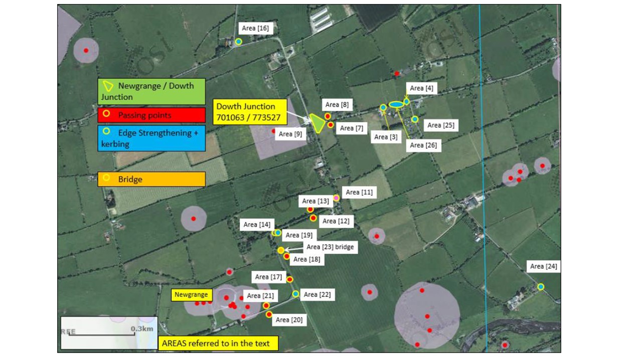
ITM: E 701063m, N 773527m
Latitude, Longitude (decimal degrees): 53.701649, -6.469427
Meath County Council, in consultation with the Office of Public Works and the Brú na Bóinne Interpretative Centre, undertook improvements to the L1607 and the minor road to Newgrange Monument in April and May 2016. All works were completed inside the Core Area to the Brú na Bóinne UNESCO World Heritage Site (WHS). The main area of works was the reconfiguring of the L1607 triplesplay Newgrange-Dowth road junction (originally installed in the 1970s and now a redundant layout), totalling 392sq m. Other limited works: typically edge strengthening 0.75m wide
for bus passing points and some additional kerbing to direct surface drainage were completed at 19 Area locations totalling 217sq m. Monitoring works were not Licensed. The dispersed works have been combined in the following summary:
Post-glacial clay and a brick earth-type windblown deposit was seen on average 0.3m below present ground surface roads and verges.
No evidence of activity during prehistory or medieval periods. However, a narrow bridge on the Newgrange Road to the east of Newgrange Tumulus does have a pointed-profile arch that might indicate some medieval origin.
A large pit containing some crusted lime-rich deposits was found truncated by the Newgrange Road to the east of Newgrange. Another feature in this area may have been a furrow.
Construction of the north-south running Newgrange Road. The Bernard Scalé, Caldwell Estate map of 1766 shows the present road network in place. One section of this road was designed to act as a formal alleé to a farm presumably occupied by the Berrell family. This part of the road has grassed verges 4.25m wide,
whereas the typical verge was 1.25-1.5m wide. This road was probably carried over a stream and dammed pond via a masonry bridge on a causewayed embankment to the east of Newgrange Tumulus. This road was in a construction-cut dug to glacial till and then had a single base layer c.100mm thick of clay and gravel and then a surfacing of another 100mm or so of gravels. These gravels are now covered in modern tarmac. In the area of the Dowth Road junction there were three distinct road and use surfaces totalling around 400mm below modern tarmac. The original cambered road was around 3m wide, associated with shallow roadside gutters which lead to a verge and, where not in cutting or on an embankment, lead to a roadside ditch and a boundary bank.
Construction of the east-west Dowth Road (presumably the ‘Great Avenue’ referred to in 1736). This road was in a construction cut to glacial till and then had a single base layer c.100mm thick of clay and gravel (where a complete iron horseshoe of late 17th – early 18th-century ‘keyhole’ type was found); and then
a surfacing of another 100mm or so of gravels. A subsequent resurfacing was seen for another 100mm or so below modern road levels. The original cambered road was around 3-4m wide, associated with shallow roadside gutters (now under the widened, present road) which led to a verge 1.5-1.75m wide and, then a ‘roadside’ ditch 1.75–2.5m wide and a boundary bank.
Post-medieval ploughsoil, 18th – 20th century. Some 1970’s road-widening works had expanded into some previous roadside fields. Some post-medieval horseshoe nails were noted in this material.
Modern services and drainage runs, corner and junction realignment works of early 1970s to 1990s and some modern, private house entrances were noted throughout the area.