2016:848 - DOWTH, Meath
County: Meath
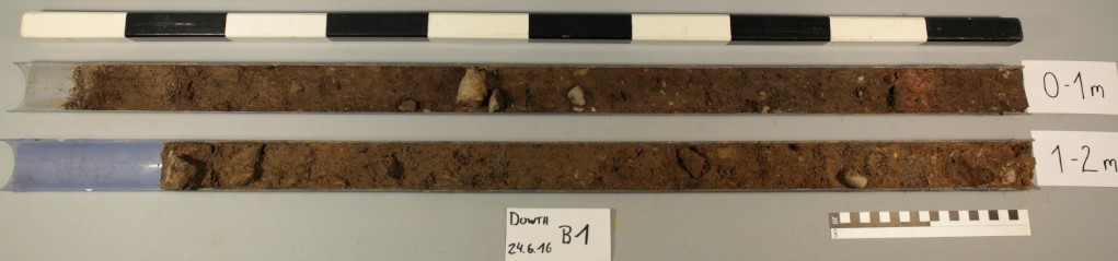
Site name: DOWTH
Sites and Monuments Record No.: ME020-075
Licence number: 16E0347
Author: Knut Rassmann, Stephen Davis, Roman Scholz & Clíodhna Ní Lionáin
Author/Organisation Address: Römisch-Germanische Kommission, UCD School of Archaeology, & Devenish Nutrition
Site type: Excavation - miscellaneous
Period/Dating: Multi-period
ITM: E 702986m, N 773989m
Latitude, Longitude (decimal degrees): 53.705423, -6.440162
In June 2016, the Römisch-Germanische Kommission (RGK), in partnership with Devenish Nutrition and UCD School of Archaeology, carried out a minimally invasive investigation of six magnetic anomalies previously identified during geophysical survey (Detection Licence No. 12R0080) on the Devenish Lands at Dowth. Drilled under Licence 16E0347, two cores were taken from the inner (Drill Core B1) and second (Drill Core B2) ditch of a large, trivallate ringfort (ME020-075–) located to the south of Dowth Hall (Chapel House Field). The remaining drillings targeted four anomalies—three pits (Drill Cores B3-B5) and a possible enclosure (Drill Core B6)—in the area between Dowth Hall and Dowth Henge (the Henge Field), which appears to be the location of a significant prehistoric landscape. The cores were taken using a percussion drilling system, which is a standard, minimally invasive, archaeological procedure. The focus of the subsequent chemical investigations was initially on phosphorus values as an indicator of settlement activities.
The coring programme provided information about the morphology, use, and possible chronology of the selected anomalies. The substantial ditches enclosing the ringfort were previously identified by geophysical survey, which indicated that the inner ditch is slightly wider (8–9m) than the second ditch (6–7m). The cores, which were not taken at the deepest point of the ditches, recorded a minimum depth of 1.5m for the inner ditch, and 2.68m for the second ditch. Multichemical analyses recorded elevated phosphorus levels for both ditches (inner ditch: 6000–8000ppm; second ditch: 2000–4000ppm), but the higher levels in the inner ditch, alongside elevated calcium levels (ash from fires), suggest that it contained more everyday settlement waste, with less intensive dumping of material in the second ditch. This appears to confirm the use of the inner enclosure as a domestic space, while the middle enclosure was probably used for other activities.
In the Henge Field, the coring programme provided information about the depths of the anomalies. While most were relatively shallow (0.5–0.8m), one pit (Drill Core B5) appears to be substantial, possibly reaching a depth of 1.6m. The lower phosphorus levels (1000–1200ppm) in all of the features cored in the Henge Field suggest that they do not contain settlement material, which would appear to support the current hypothesis that the concentration of anomalies in this area represents a ritual, non-domestic, landscape, possibly dating to the Late Neolithic. Phosphorus levels can reduce over time due to plant growth, and the low levels recorded may indicate that these features are of a significant antiquity.
The coring programme formed part of the UCD School of Archaeology Research Programme for the Devenish Lands at Dowth, which has to date involved the extensive use of non-invasive archaeological techniques to better understand the landscape at Dowth and its individual monuments. Recommendations for future investigation include the drilling of multiple cores across the ditches of ME020-075– to determine their profiles, as well as targeting other medieval sites and potentially prehistoric anomalies on the estate.