2016:762 - ATHLUMNEY, Meath
County: Meath
Site name: ATHLUMNEY
Sites and Monuments Record No.: N/A
Licence number: 16E0268
Author: Padraig Clancy, CDHC
Author/Organisation Address: Lynwood House, Balinteer Road, Dublin 16
Site type: Enclosure and Burial
Period/Dating: Multi-period
ITM: E 689253m, N 766994m
Latitude, Longitude (decimal degrees): 53.645108, -6.650106
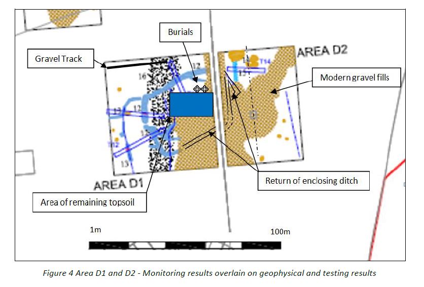
Monitoring was carried out over 4 days in July 2016. The works were carried out on behalf of Granbrind Athlumney Ltd in relation to a proposed residential development comprising 310 residential dwellings. The proposed development site is located in an area of open pasture fields straddling the townlands of Alexander Reid and Bailis. The areas of monitoring focused on Areas D1, D2 and E, and were informed by previous archaeological investigations on site (geophysical survey 11R049 by Leigh, and testing 11E240 by Walsh). These investigations had identified an enclosure in Area D measuring c. 70m west–east by 35m, with a width of 2.5–4m, and depth of 0.8m.
Following consultation with the National Monuments Service it was decided that topsoil stripping would take place in Areas D1 and D2 in zones measuring 100m x 80m and 100m x 60m respectively to verify the extent of the enclosure and identify any associated features, whilst Area E was investigated with two box trenches as a stand-alone archaeological exercise. All monitoring work was carried out using a 14-tonne tracked JCB excavator fitted with toothless grading bucket.
Stripping of the topsoil in Area D1 and D2 confirmed the presence of a sub- rectangular shaped enclosure with rounded corners. Along the western extent of this feature, a possible entrance way (c. 2m wide) was noted as the ditch appears to be truncated. Also, a second enclosing feature/or an annex was noted. In general, the enclosure measures 60m east-west x 35m and with the annex on its western edge; the feature was recorded as being 10m x 30m in extent. The width of the enclosing ditch averaged from 1–2.5m.
Human remains in the form of articulated bone possibly representing two east-west burials were noted and bone fragments were scattered throughout the interior of the enclosed area. Located in close proximity to each other, the most northerly remains were well-preserved with pelvic and leg bones exposed during topsoil stripping. It was orientated east-west in a supine position. The southern remains were badly disarticulated with only fragments of long bones revealed by the topsoil stripping. The area of skeletal remains were recorded and then covered with a protective layer.
Monitoring in Area E confirmed the presence of field boundaries and a townland boundary. No other archaeological features were apparent during the stripping of topsoil.
Excavation was subsequently carried out on Area D under Licence 16E0449 in February to May 2017 by Archaeology Plan revealing multi-phase occupation of the site from an early medieval settlement to a post-medieval burial ground (containing a total of 38 burials).