2016:879 - Dunkellin Flood Relief Scheme (Craughwell and Ballymore), Galway
County: Galway
Site name: Dunkellin Flood Relief Scheme (Craughwell and Ballymore)
Sites and Monuments Record No.: N/A
Licence number: 16E0481
Author: Dominic Delany
Author/Organisation Address: Dominic Delany & Associates
Site type: Bridge
Period/Dating: Modern (AD 1750-AD 2000)
ITM: E 551014m, N 720080m
Latitude, Longitude (decimal degrees): 53.228854, -8.733662
The Dunkellin River Flood Relief Scheme extends from c.200m upstream of Craughwell Bridge, to c.400m downstream of Killeely Bridge near Kilcolgan in South County Galway. The works are divided into three areas: Craughwell village and environs in the east extent of the scheme, Rinn Bridge west of Rahasane Turlough in the centre, and Dunkellin Bridge to Killeely Bridge in the west extent of the scheme. The scheme was preceded by archaeological testing at Dunkellin (2016:208) and Killeely More (2016:207) in August 2016.
Development works carried out in August-December 2016 consisted of site investigations at Craughwell Railway Bridge and Craughwell Bypass Bridge, excavations within the existing bypass channel to the east of Craughwell Bypass Bridge, and topsoil strip along the route of the proposed new bypass channel to the southeast. The existing bypass channel on the east side of the bridge is a modern linear cut with a high shuttered concrete retaining wall on the north. This section of the channel was reduced by between 0.4m and 0.9m, revealing 0.2m of silt and roots over light brown silty/clayey sand. Topsoil strip along the route of the proposed new section of channel to the southeast revealed 0.2m of dark grey/brown clayey silt topsoil over light brown clayey silt subsoil. No archaeology was found.
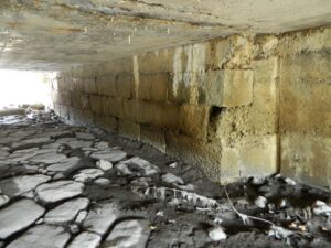
The remains of a previously-unrecorded stone bridge were identified within both channels of the existing bypass bridge. The stone bridge was sandwiched between modern concrete extensions to the east and west, and capped with a concrete slab bridge deck. The channels were 6.5m long and 2.45-2.75m wide. The pier walls were faced with 3-4 courses of large, roughly-dressed, ashlar-type limestone blocks, and the floors were paved with large sub-rounded irregular limestone boulders and packing stones. A reinforced concrete slab formed the bridge deck, just 1m above the stone floors. The use of ashlar-type limestone blocks is consistent with the third phase of construction in the main bridge at Craughwell, which is tentatively dated to the late 18th century. The proposal was to replace the existing bridge with a new structure. There was no scope to retain any part of the existing bridge as the new channel was significantly wider and deeper than the existing channel.