2016:690 - MONTPELIER HILL, Dublin
County: Dublin
Site name: MONTPELIER HILL
Sites and Monuments Record No.: DU025–001001
Licence number: 16E0497
Author: Neil Jackman, Abarta Heritage
Author/Organisation Address: 1 Dillon Street, Clonmel, County Tipperary
Site type: Megalithic tomb - passage tomb
Period/Dating: Prehistoric (12700 BC-AD 400)
ITM: E 311496m, N 223648m
Latitude, Longitude (decimal degrees): 53.251769, -6.330298

Figure 1: Location of Montpelier Hill
This excavation was carried out at Montpelier Hill, County Dublin, as part of the Hellfire Club Archaeological Project, a not-for-profit research project by Abarta Heritage with funding and support from South Dublin County Council and Coillte. The excavation consisted of two hand-excavated test-trenches that were opened into the monument designated DU025-001001, identified as a passage tomb by the Archaeological Survey of Ireland. Historical accounts reported that the cairn of the tomb had been destroyed in 1725 and its stone quarried to use as building material for the hunting lodge that stands immediately to the north of the remains of DU025-001001. This hunting lodge was built for William Conolly, but later became synonymous with the infamous 18th-century organisation known as the ‘Hellfire Club’.
The aims of this programme of excavation were to:
- Examine the nature of the monument DU025-001001 and to seek to conclusively identify its site type.
- To establish the condition and preservation of below-surface archaeological features
- To accurately assess, record, sample and excavate all archaeological contexts encountered.
- To identify and retrieve material for dating purposes to better understand the chronology of the monument, and, if the monument was to be confirmed as a passage tomb, to contribute towards the overall chronological understanding of megalithic tombs in Ireland.
- To carry out an accessible archaeological excavation that would help to raise awareness and to engage and educate the general public, particularly local schools, about the practice of archaeology, and to help to tell the story of Montpelier Hill and the Dublin Mountains.
The excavation revealed that the low horseshoe-shaped mound at the rear of the hunting lodge building does indeed represent the quarried remains of a Neolithic passage tomb. The excavation identified an assemblage of artefacts consistent with the Irish passage tomb tradition, such as megalithic art, a polished stone axehead, lithics and a possible mushroom-headed bone pin. Radiocarbon dates obtained from secure contexts range in date from 3651–3377 cal BC, suggesting that this monument dates to the mid-Neolithic period, though further work is required to be more certain of the tomb’s chronology. The excavation also provided physical evidence of the historically recorded quarrying and destruction of the tomb in the eighteenth and nineteenth century.
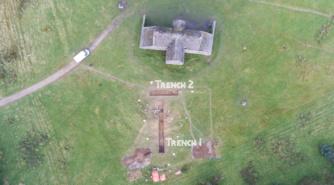
Figure 2: Trench Locations
Trench 1
Trench 1 measured 15m x 2m and it was aligned north-south. The trench extended from the south of the monument, into its centre, and traversed the mound at its highest point. The purpose of Trench 1 was to ascertain whether the mound did indeed represent the in-situ remains of a prehistoric tomb, and if so, to assess the archaeological potential of the remains and the level of disturbance of the early modern period. Another key aim of the trench was to retrieve any material suitable for radiocarbon dating. The trench revealed that part of the cairn still survived intact, though its upper levels were badly truncated by quarrying. It also revealed an interesting series of contexts that consisted of layers of clayey-type material. This has been interpreted as turves that were stacked at the base of the cairn to stop it slipping outwards.
The lowermost layer of these contexts was radiocarbon dated to 3636–3377 cal BC (2 Sigma) (UBA–34835). A sample of hazel charcoal from the context immediately above that returned a radiocarbon date of 3651–3522 cal BC (2 Sigma) (UBA–34834). A sample of oak charcoal from a pre-cairn context that was located directly underneath the cairn, returned a date of 3782–3640 cal BC (2 Sigma) (UBA–34836).
The trench also demonstrated the dramatic extent of the eighteenth- and nineteenth-century quarrying of the tomb, with a robber trench identified where the kerb had been removed, and a large cut that chopped through all but the lowest levels of the cairn. More quarrying was identified at the northernmost end of the trench, where there was evidence of the attempted removal of a large stone, quite possibly an orthostat that once stood upright at the southernmost side of the burial chamber. Prehistoric artefacts recovered from Trench 1 included a large green greywacke boulder with megalithic art that was found out of its original setting, a possible mushroom-headed bone pin and a number of pieces of flint and chert.
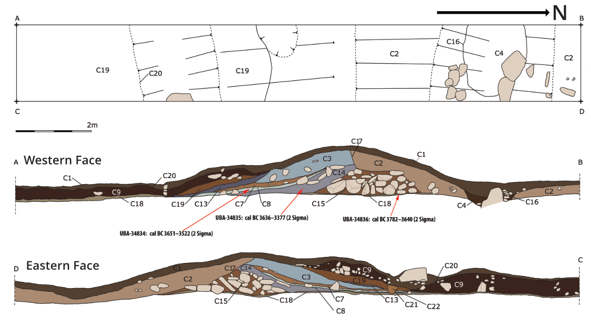
Figure 3: Plan and section drawing of Trench 1, showing location of radiocarbon dates.
Trench 2
Trench 2 measured 10m x 2m, and was orientated east-west in the northern part of the tomb, just to the south of the hunting lodge. The trench was positioned to evaluate the potential for sub-surface archaeological features to survive even in the most disturbed and damaged part of the monument. At this part of the monument, the circular mound is largely invisible having been largely removed and flattened during the construction of the hunting lodge. Unsurprisingly Trench 2 revealed extensive evidence of the disturbance and destruction of the eighteenth century, however it also revealed a secondary phase of quarrying, where the hunting lodge itself was ransacked for useful building material, presumably in the nineteenth century.
Eighteenth-century brick and mortar was found within a mixed context. A polished stone axehead of porphrytic dolerite was also found ex-situ, along with two pieces of flint. At the easternmost side of Trench 2, archaeological contexts were identified surviving in-situ. These contexts were similar in nature to those identified in Trench 1, and presumably represent the lowermost level of the truncated cairn.
Conclusion
This initial exploratory investigation of DU025-001001 has revealed that significant archaeological remains are still present in-situ, despite the severe disturbance and damage caused to the tomb in the eighteenth and nineteenth centuries. The full results of this excavation are detailed in the publication Sacred Skies and Earthly Sinners – The Hellfire Club Archaeological Project, available as a free ebook from www.abartaheritage.ie.