2016:428 - BLACKHALL PLACE: Law Society of Ireland, Dublin
County: Dublin
Site name: BLACKHALL PLACE: Law Society of Ireland
Sites and Monuments Record No.: DU018-020
Licence number: 13E0281(ext)
Author: Ed Danaher, CRDS Ltd.
Author/Organisation Address: 2 Grosvenor Terrace, Monkstown, Co. Dublin, A94 Y209
Site type: Historic town
Period/Dating: Multi-period
ITM: E 714279m, N 734530m
Latitude, Longitude (decimal degrees): 53.348631, -6.283592
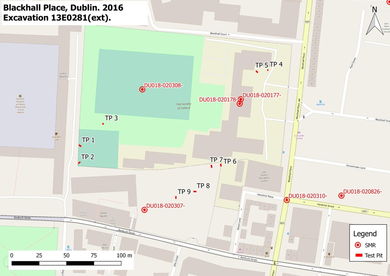
Licensed archaeological monitoring of site investigations work at the Law Society of Ireland, Blackhall Place, Dublin 7 was carried out by Ed Danaher for CRDS Ltd, at the request of Howley Hayes Architects on behalf of the Law Society of Ireland. The development comprises the upgrade, addition and intervention works to the southern block and curtilage of the Law Society of Ireland buildings. The site is occupied by the former Blue Coat School, now the Law Society of Ireland, and is located within the Zone of Archaeological Potential for Dublin City (DU018-020—). There are also four recorded archaeological monuments within the development site. Condition 5C of a grant of planning from Dublin City Council (Ref. 2678/16) required licensed archaeological monitoring of all demolition and sub-surface works associated with the development including the breaking and removal of any floor slabs, levelling of ground etc. Nine test pits (TP) were excavated for site investigation works in November 2016. These were as follows:
Test Pit 1 (ITM 714187E ,734504N) measured 0.6m by 0.6m and was excavated to a depth of 1.4m. The test pit uncovered building rubble layers along the face of Collins’ Barracks boundary wall, the boundary wall foundations, and was excavated to natural subsoil. Test Pit 2 (ITM 714186E ,734488N) measured 2m by 0.6m and was excavated to a depth of 2.05m. The test pit uncovered buried tarmac and concrete layers, made ground and a dark buried sod layer with brick inclusions, and was not excavated to natural subsoil. Test Pit 3 (ITM 714208E ,734524N) measured 1m by 1m and was excavated to a depth of 2.35m.
The test pit uncovered made ground containing North Devon Sgraffito ware and building rubble, and was not excavated to natural subsoil. Test Pit 4 (ITM 714359E ,734573N) measured 0.9m by 0.6m and was excavated to a depth of 0.6m. The test pit uncovered two courses of wall foundations, and was not excavated to natural subsoil. Test Pit 5 (ITM 714349E ,734571N) measured 0.9m by 0.6m and was excavated to a depth of 0.6m. The test pit uncovered two courses of wall foundations, and was not excavated to natural subsoil. Test Pit 6 (ITM 714316E ,734486N) measured 1.2m by 0.6m and was excavated to a depth of 1.25m. The test pit uncovered a rubble layer over a concrete layer, a metalled surface over made ground, and was not excavated to natural subsoil. Test Pit 7 (ITM 714307E ,734485N) measured 1.2m by 0.6m and was excavated to a depth of 1.25m. The test pit uncovered layer of concrete over rubble containing modern refuse with plastic, and redeposit soil, and was not excavated to natural subsoil. Test Pit 8 (ITM 714292E ,734462N) measured 2m by 0.6m and was excavated to a depth of 1.3m. The test pit uncovered mixed redeposit soils with modern refuse, and was not excavated to natural subsoil. Test Pit 9 (ITM 714275E ,734456N) measured 2m by 0.6m and was excavated to a depth of 1.25m. The test pit uncovered rubble, stone, and redeposit soil layer, and was not excavated to natural subsoil.
Archaeological features uncovered during the archaeological monitoring of site investigation works were limited to known features on site including the foundations of the boundary wall of Collins Barracks (TP2) and the foundations of the screen wall (TP4 and TP5). Archaeological find recovered were limited to two sherds of North Devon Sgraffito Ware (TP3).
It was recommended that, due to the archaeological sensitivity of the site and the presence of recorded archaeological monuments within the site, ground works associated with the construction phase of the project should be subject to licensed archaeological monitoring.