2016:421 - DUBLIN: 124 The Coombe, Dublin
County: Dublin
Site name: DUBLIN: 124 The Coombe
Sites and Monuments Record No.: N/A
Licence number: 16E0080
Author: Martin E. Byrne, Byrne Mullins & Associates
Author/Organisation Address: 7 Cnoc na Greine Square, Kilcullen, Co. Kildare
Site type: Historic town
Period/Dating: Multi-period
ITM: E 714942m, N 733474m
Latitude, Longitude (decimal degrees): 53.339002, -6.274023
A limited programme of testing and monitoring of geotechnical Investigations took place with respect to a proposed hotel development at 118–128 The Coombe. The investigations were undertaken within Site/Plot No. 124 as the remaining areas (125–128) were unavailable for investigations due to the partial remains of existing buildings and associated demolition spoil mounds. Nos 118–123 was excavated by Clare Walsh (Excavations: 2010:258) which revealed an early roadway 4m in width, flanked by a 4m-wide ditch, which extended east–west across the entire site. This had been infilled, and the street end laid out into seven adjacent plots. Clay-floored post-and-wattle houses, of striking similarity, with four internal roof supports, all with central hearths, were constructed on the plots. The dates of the houses are likely to be late 11th to early 12th century (Walsh, C. 2012. pp. 113–137).
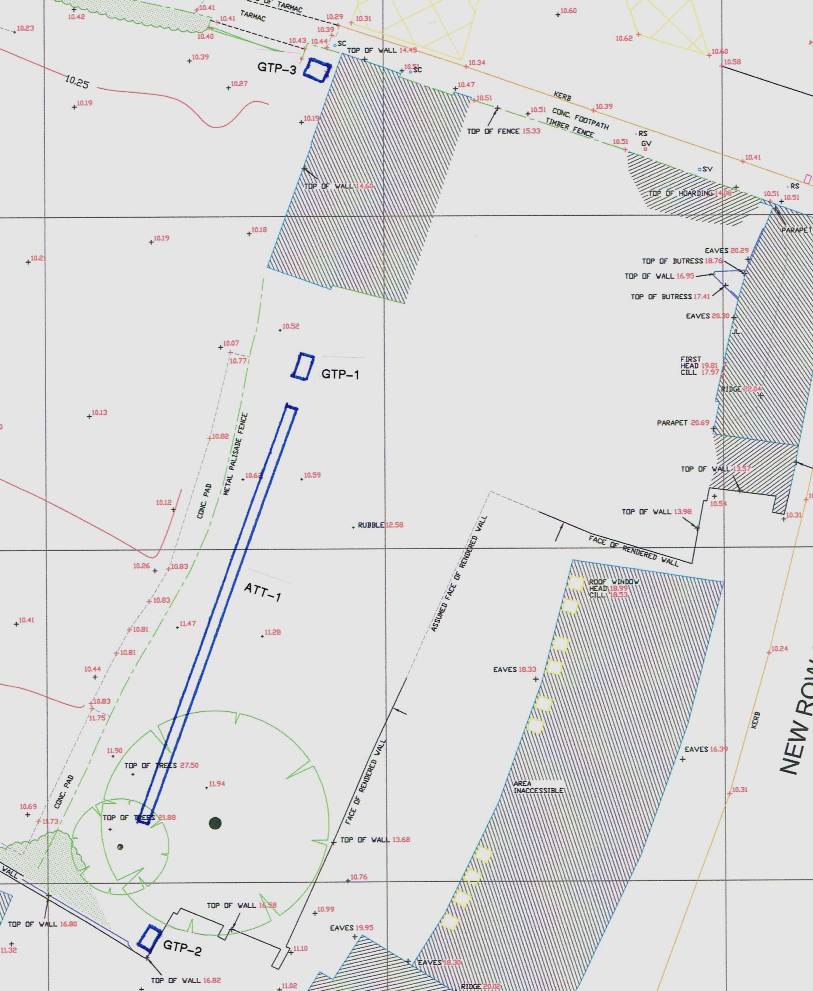
One single trench (ATT-1), aligned north-south, was excavated along the centre of the rear garden area to No. 24. Compact grey/green/brown silty clay (L3) with occasional inclusions of shell and animal bone was uncovered, from which three sherds of pottery of medieval date, were recovered. The levels on the surface of L3 ranged from 9.7m in the south to 8.73m in the north and it was up to 0.3m in depth/thickness. The trench was subsequently deepened to expose the surface of the underlying subsoils and the spoil from L3 was carefully raked through and visually inspected. There were no indications of inclusions of any wooden structural material. This indicates that the layer probably represents natural topsoil layer with later medieval inclusions. The levels on the exposed surface of the underlying subsoils were 9.4m in the south to 8.43m in the north.
In addition, two trial pits, GTP-1 and GTP-2, were excavated to the north and south of ATT-1, and both had a similar stratigraphy to ATT-1. In the case of the northern trial pit (GTP-1) the level on the surface of L3 was 8.71m, with the subsoil exposed at 8.45m, while the surface of L3 within the southern trial pit (GTP-2) was 9.39m and the subsoil was uncovered at 9.08m.
A third trial pit (GTP-3) was excavated in the north-eastern corner of No. 123, immediately outside the existing line of basement piles, and outside the area excavated by Clare Walsh. In this case the rubble fill was 1m in depth from the present ground surface and lay directly upon black organic silty clay, with occasional inclusions of animal bone. No datable material was recovered from this layer, which was up to 0.94m in depth/thickness and sealed a further layer, similar to that described as L3, at 9.17mm, with the subsoil exposed at 8.83m.
It was recommended that further testing of the site was required, although such can only be undertaken following demolition of the remaining structures and removal of the soil mounds.
Reference
Walsh, C. 2012. ‘The excavation of an early roadway and Hiberno-Norse houses at the Coombe’ in Duffy, S (ed.), Medieval Dublin XII – Proceedings of the Friends of Medieval Dublin Symposium 2010, pp. 113 – 137