2016:391 - BARBERSTOWN, Dublin
County: Dublin
Site name: BARBERSTOWN
Sites and Monuments Record No.: N/A
Licence number: 16E0335
Author: Gill McLoughlin, Courtney Deery Heritage Consultancy
Author/Organisation Address: Lynwood House, Ballinteer Road, Dublin 16
Site type: Enclosure
Period/Dating: Undetermined
ITM: E 714168m, N 744545m
Latitude, Longitude (decimal degrees): 53.438618, -6.281638
Archaeological test trenches and monitoring of geotechnical investigations were carried out in relation to the North Runway development at Dublin airport in response to an An Bord Pleanála planning condition. The new runway development is located to the north and parallel to the existing main runway. Testing was carried out in two fields where low-lying features of archaeological potential were noted during the EIA process for the North Runway. These sites were recorded as a sub-circular depression (CHS 2) and small low profile undulations (CHS 6). The testing of these areas was preceded by detailed geophysical survey, which did not reveal any specific responses at the locations of CHS2 and CHS6, however it did reveal features of archaeological potential in the vicinity (Sites C and D) that were unrelated to the surface features. Site C was identified as a rectangular enclosure/field system and Site D represents an isolated linear feature with some faint linear and curvilinear trends in the same field.
The testing programme was carried out from 9–12 August 2016 and 15 trenches were opened across these two fields ranging in length from 8–35m. Trenches were excavated across the features and anomalies identified in the geophysical survey of the fields.
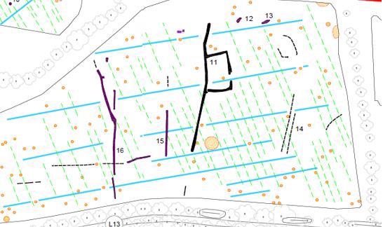
Site C presented as a rectangular ditched enclosure in the geophysical survey, measuring c.17m by 28m with a possible entrance to the east. The western portion extends mainly north-east/south-west across the field and further weak linear features and positive responses of potential interest were also indicated in the same field. Testing did not definitively confirm the presence of the rectangular enclosure, and a large deposit of marly clay encountered over this entire area of the field may have masked what is represented as a strong geophysical survey response.
The linear ditch (1.5m in width x 0.5m depth), associated with and running south from the enclosure, contained a single fill with occasional charcoal, shell and burnt bone and is considered to be archaeological in nature. Also of interest was a metalled trackway identified in T7, to the south-east of the enclosure. It measures 1.7m wide and is flanked by parallel drainage ditches on either side measuring 1.25m wide x 0.43m deep. No diagnostic material was identified in any of the trenches opened.
Site D presented as a north-east/south-west linear traversing curving weak trends. Seven test trenches (T9–T15) were excavated in this field and only the linear north-east/south-west orientated ditch was found to be of archaeological interest. It measured 2m in width and 0.54m deep and contained three fills, the middle fill being rich in charcoal with frequent burnt bone, occasional unburnt bone and a piece of flint. The curving trends are likely to be natural geological trends picked up by the geophysical survey and were not of archaeological interest.
Townland boundaries
The standing remains of the townland boundaries within the North Runway development lands were also investigated and comprised test trenches across five sections of the Barberstown/Pickardstown, Kingstown/Barberstown and Dunbro/Pickardstown townland boundaries. The boundaries were found to be generally uniform in nature, comprising ditches measuring at least 3m wide and almost 2m deep with a natural accumulation of humic fill found in their base. The Kingstown/Barberstown boundary had a roughly coursed rubble stone wall on its eastern side and a corresponding low bank on the western side. The wall measured c. 1.05m in height and appears to run the length of the field to the west. It is likely to be a former property boundary demarcating lands associated with Barberstown House which was located on the northern side of the Naul Road.
Site investigations
Site investigations (SI) were undertaken for a variety of engineering purposes across both the Airside and Landside areas. The investigations comprised trial pits (18 Airside and 70 Landside) including plate tests alongside the trial pits, soakaways (3 Airside, 2 Landside) and boreholes. With the exception of the boreholes all the SI works were monitored as they required the opening of areas measuring at least 1.8m x 3.2m and were up to 3m in depth. Monitoring of these works was carried out in July and August 2016 and nothing of archaeological significance was noted.
A second phase of testing targeting potential archaeological sites identified in the geophysical survey were subsequently tested by Claire Cotter in November/December 2016 under an extension to this licence.

