2016:627 - COOLFADDA, Gully, Cork
County: Cork
Site name: COOLFADDA, Gully
Sites and Monuments Record No.: CO110-019014
Licence number: 16D0074, 16R0161
Author: Edward Pollard, Judith Carroll & Company, Archaeological Consultants
Author/Organisation Address: Pine Forest Centre, Ballybrack Road, Dublin 18
Site type: Weir - regulating, Building, Quay, Riverine revetment and Town defences
Period/Dating: Multi-period
ITM: E 548901m, N 555121m
Latitude, Longitude (decimal degrees): 51.746093, -8.739997
A non-intrusive dive survey took place around Bandon Town Weir for a new fish pass to be constructed, and dredging of the River Bandon downstream for the Bandon Flood Relief Scheme.
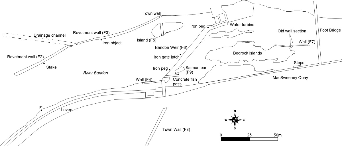
Feature 2 is dry stone walling on the river bank and is a revetment wall that also acts as a field boundary dating from the late 18th century. It is found on the north side of the river. Opposite the island (F5) the stone walling of Feature 2 continues until reaching the town wall. Feature 4, a stone wall, is on the south bank of the river extending 20m west of the town wall. The western side of the wall has been further reinforced with 20th-century concrete. It may have been a quay for boats upstream of the river.
Feature 5 is the island on the north side of the river to the west of the weir. This is marked as a tower on Bernard Scalé’s 1775 map of Bandon. It has dry-stone walling on its southern, northern and western sides. The walling is 1.8m high above the river bed and disappears into soil for 0.6m until the top of the island cliff. Apart from the middle of the island, where the town wall crosses the island north to south, there is no evidence of walling on top of the island but a deep soil has built up from the vegetation obscuring any features.
The town wall on the north side of the island has protruding slabs under the waterline, which may relate to the steps marked beside a round tower on the Hardiman 1620 map. The survey revealed three ‘steps’ visible below the waterline. They are 500mm long and there is a gap of 400mm between each step. They protrude from the wall into the river for 300mm.
Feature 6, Bandon Weir, extends from the town wall on the southern side to a hydroelectric turbine near the north bank. The weir is made of vertically set stones averaging 400mm by 200mm in size. The southern side has the concrete fish pass with an iron grate on the upstream side. The remains of the salmon bar (F9) can clearly be seen immediately north of the concrete fish pass. This is referred to locally as the ‘Queen Anne fish pass’ dating it to the early 18th century. In profile the weir has vertical sides and a downstream sloping upper surface. Pebbles and gravel concrete repair on the upstream and downstream sides of the weir has led to some parts on the upstream side having a concrete ledge. An iron rectangular peg was recorded placed vertically on the north side of the weir near the turbine intake. It is 130mm by 30mm by 30mm and snapped off at the top. It is a construction peg associated with the weir and lies 53m from the fish pass. A second rectangular peg is placed 7m from the fish pass into the river bed on the upstream side of the weir. It is the same shape but has corroded.
A hammer-forged gate latch was found on the riverbed upstream of the weir (0.5m west from the weir and 23m from the modern concrete fish pass). This may have come from the heavy iron gate that was supposed to have guarded the river entrance to the town.
Feature 7 is the wall downstream of the weir and upstream of the early 20th-century footbridge. It is built on a bedrock island. On the eastern end of the wall, Feature 7 is thin shuttering concrete (similar to that in F4) with bands of mixing that are probably 20th century in date. Within the wall is an older wall made of limestone blocks. This wall section is 2.9m long and 0.7m wide. The old wall corresponds with the steps at MacSweeney Quay. The old wall was probably a quay for boats taking goods and materials to and from Bandon with the later concrete structure associated with 20th-century fishermen taking advantage of salmon gathering below the weir. The location of the older wall close to the steps of MacSweeney Quay and the tanyard, fish store and Scott’s Factory, present nearby in the town in the 19th century, indicate that many industries would have been using water transport. ‘The Stream’ is shown flowing past this wall in the 19th-century OS maps indicating a deeper navigable channel was previously here.

