2015:613 - CARLANSTOWN: N52 Owenroe River (Moynalty River) Bridge, Meath
County: Meath
Site name: CARLANSTOWN: N52 Owenroe River (Moynalty River) Bridge
Sites and Monuments Record No.: N/A
Licence number: Unlicensed
Author: Niall Roycroft
Author/Organisation Address: c/o Meath County Council
Site type: Bridge
Period/Dating: Modern (AD 1750-AD 2000)
ITM: E 676406m, N 779258m
Latitude, Longitude (decimal degrees): 53.757327, -6.841339
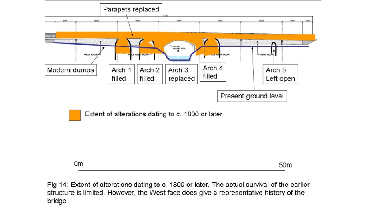
Meath Protected Structure Map 11, Number 103 (NIAH 14308001) N52 Owenroe (Moynalty) River Bridge at Carlanstown suffered a partial collapse in the north-east corner of the retaining wall in November 2014. A survey has shown that the 70m long, north-south oriented, single-arched bridge retains elements from a probable 16th-17th-century four to five arch bridge that is illustrated on the 1654 Down Survey. The Bridge is not a Recorded Monument.
The original elements are visible along the western side only and consist of three broken and infilled arches, each arch originally c. 3.5m wide. It is assumed that the humpback profile of the Down Survey Carlanstown Bridge was caused by a large 6–7m wide central arch over the Owenroe River. The humpbacked bridge was converted into an almost horizontal bridge around 1800 (there is a slight hump still but the deck is mostly flat). This involved taking off the keystone tops to all the 3.5m wide arch rings and subsequent infilling of the arch voids. It also included a full replacement of the 6–7m wide arch. New parapets were also raised at this time and the bridge was also widened by c.2.5m all the way down the eastern side. There are no visible cutwaters or pedestrian refuges. A small open arch (0.6m wide) that probably formed part of a 16th-century mill race which was retained in the widening of c. 1800, still exists near the southern end of the bridge. The relatively wide Owenroe River floodplain has been infilled from 1830s onwards and raised with modern dumps of 1-2m. The central arch was blown up in 1920 and subsequently repaired. The coping on the eastern parapet over the bridge arch is almost wholly concrete, whereas the coping on the western side is genuine masonry. All other parapet capping is modern concrete. The Owenroe River channel of bedrock has already been deepened and lined with concrete scour protection.
The Record of Monuments and Places for County Meath names 18 bridges which are pre-1700 in date. A systematic review of the Down Survey mapping for County Meath shows that 38 bridges are illustrated in and around 1654. The National Inventory of Architectural Heritage names 57 bridges in County Meath, many of which are of a similar build to that at Carlanstown (particularly railway bridges).
Encasing the bridge in modern materials would mean the loss of the Protected Structure in the landscape and would impact on the heritage of Carlanstown. The original bridge elements are currently publicly accessible. However they are in a degraded condition and most of the present bridge is visibly 1800 in date or later. This 1800 bridge is of a style that is common throughout County Meath and which can be replicated in a new structure. It would also be possible to recreate the arch ring stones of the original bridge using modern stone on any new retaining walls.
Ideally, the bridge would be widened on the eastern side only. This side is visibly bulging and collapsing in numerous places both north and south of the River and this is the side that dates to c.1800. The parapet on the both eastern and western sides is also c. 1800.