2015:212 - DOWTH, Meath
County: Meath
Site name: DOWTH
Sites and Monuments Record No.: ME020-012
Licence number: 15E0299
Author: Clíodhna Ní Lionáin (Devenish) and Steve Davis (UCD School of Archaeology)
Author/Organisation Address: UCD School of Archaeology, Belfield, Dublin 4
Site type: Barrow - mound barrow
Period/Dating: Prehistoric (12700 BC-AD 400)
ITM: E 702940m, N 773983m
Latitude, Longitude (decimal degrees): 53.705378, -6.440861
Following consultation with the National Monuments Service, the extensive vegetation on the small mound (ME020-012) to the west of Dowth Hall was cut back by hand in February 2015. A second phase of cleaning, targeting the thick layer of leaf litter on the mound, was carried out under licence over an eight-day period in June and July 2015. This cleaning and recording project, which forms part of the UCD School of Archaeology Research Programme for the Lands at Dowth Hall (Project Leader Dr Steve Davis), enabled geophysical survey to be subsequently undertaken at the site in September 2015.
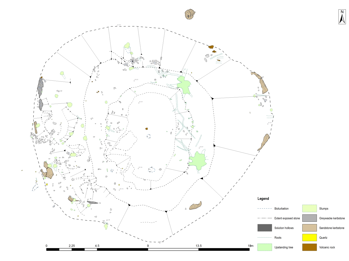
Also known as Site I, ME020-012 is a small, low, sub-oval mound (19.3m east-west x 18.8m x 0.9-1.26m high) with a central depression (10.8m north-south x 7.1m x 0.18-0.47m deep) possibly caused by the collapse of an underlying structure, by quarrying, or by other invasive activity. Though classified as a barrow, the presence of thirteen kerbstones (ranging in length from 0.81-1.76m) around its perimeter suggests that it could be a passage tomb, similar to the nearby site of ME020-013, which is located c. 44m to the south. A possible entrance area was noted on the west side of the mound, where the majority of artefacts (all lithics) were located, including a flint arrowhead and a number of worked quartz and chert pieces.
The builders of the mound appear to have sought to incorporate different lithologies into both the kerb and the cairn itself. The kerb consists of sandstone slabs primarily, alongside three greywacke kerbstones. Both types of stone would have had to be transported to site. The cairn appears to be predominantly comprised of the same type of sandstone, but quartz and volcanic rock were also present. It is unclear what symbolism these different rock types held for the mound builders, but it is probable that their inclusion was not accidental.
Geophysical survey of the mound was undertaken in September 2015 by Earthsound (Detection Licence No. 15R0125). Ground Penetrating Radar was carried out, but due to the topography of the mound and the presence of numerous stumps, only a limited area of the mound could be surveyed. The survey detected an external ditch around the mound, enclosing an area of 22m x 19m. An east-west survey line detected an area of possible archaeological interest on the internal edge of the enclosing ditch, which could correspond to the removal of earth or the cutting of a ditch in the area of the postulated entrance. In the northern part of the mound, a large stone, which could be archaeological or geological in origin, was also detected (Bonsall & Gimson 2015). At the time of writing, post-excavation work and research is still ongoing.
References
Bonsall, J. & Gimson H. 2015. Investigations into Barrow ME020-012 and surrounding land, Dowth Hall, County Meath. (Detection Licence No. 15R0125)