2015:085 - DONACARNEY, Mornington, Meath
County: Meath
Site name: DONACARNEY, Mornington
Sites and Monuments Record No.: N/A
Licence number: 15E0029
Author: Jon Stirland, Archaeological Consultancy Services Unit
Author/Organisation Address: Unit 21 Boyne Business Park, Greenhills, Drogheda, Co Louth
Site type: Excavation - miscellaneous
Period/Dating: Multi-period
ITM: E 713211m, N 775147m
Latitude, Longitude (decimal degrees): 53.713709, -6.284943
An assessment (test trenching) took place of a proposed housing development at Donacarney and Mornington, Co. Meath. The testing was carried out in fulfilment of planning conditions associated with the grant of permission for the construction of 255 houses (Planning Ref: An Bord Pleanala PL17.243610). The site is beside a protected structure (14318001), Donacarney House, built in 1860 and which is listed within the County Meath Development plan. Although the site of the proposed development contains no Recorded Monuments the surrounding townlands have in recent years proven themselves to be rich in previously unrecorded features and deposits of an archaeological nature.
Between 23 and 26 February 2015 a total of 31 test trenches were excavated. For the purposes of the test trenching the site was divided into 6 areas: the wooded Area and Fields 1 to 5. Both Fields 1 and 2 were found to contain archaeological features and deposits but the test trenching within the wooded area and Fields 3-5 failed to identify any further features.
Two archaeological features were identified in Field 1, Trench 5. The first comprised a linear feature (F15) measuring 2.24m in length and containing a deposit of burnt stone and charcoal with a circular pit-type feature located at its north-west end. Located approximately 57m to the north of F15, a circular pit (F16) was recorded. This was rich in charcoal and contained two fills within a bowl-shaped cut. Trench 5 was extended within the area of F15 and no further associated features were identified.
Despite no further features being identified within the trenches located within Field 1, it cannot be assumed that these features are isolated. Therefore it is recommended that Field 1 be subject to monitoring during topsoil stripping.
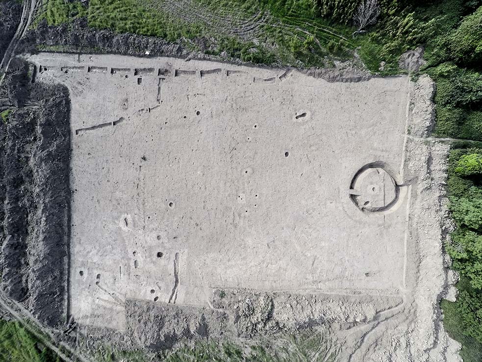
Within Field 2 a total of fourteen features of an archaeological nature were identified. The core of these features appear to be located along a low glacial ridge running south-west, north-east across the centre of Field 2 just above the 20m contour. The general appearance of the features and deposits suggests prehistoric activity, probably dating to the Bronze Age.
Within Trench 10 two pits were recorded (F10 and F11) with their surfaces rich with flecks of charcoal. Located directly to the east of pit F11 a linear ditch type feature was recorded (F12). With a width of 0.75m this ran north-south across Trench 10 with a slight suggestion that it may slightly curve to the east.
In Trench 11 two circular pits were recorded, F4 & F7, the surface of which were rich in flecks of charcoal. Trench 11 also contains a linear-type feature (F5) that may be in alignment with a similar linear feature recorded within Trench 10. Also within Trench 11 a third pit was identified (F6). This pit, rich in flecks of charcoal contains the broken base of a large pottery vessel. The vessel appears inverted within the pit and may be a Bronze Age Urn or large food vessel. Also recorded within Trench 11 towards its eastern limit was F13, a small sub-circular area of oxidised fire-reddened material that may represent a pit with in situ burning measuring 0.3m in diameter.
In Trench 12, towards the trenches northern limit, a curving ditch-type feature (F14) was recorded. This curving ditch had a width of 0.96m and its surface was rich with flecks of charcoal. Within the confines of Trench 12 this curving ditch appears to suggest the appearance of a possible ring ditch with an internal diameter of 10m.
In Trench 13, three post-holes were recorded (F1, F2, F3). They each had diameters of 0.16m and appeared to form a possible curve, suggesting a possible circular structure. F2 contained a post pipe surrounded by packing material that contained three small sherds of prehistoric pottery of possible Bronze Age date.
Two features were recorded within Trench 14, F8, an irregular shaped spread of decomposing mussel shell and charcoal and F9, a spread of charcoal.
Within Fields 3, 4 and 5 a total of 17 further test trenches were excavated but no features or deposits of an archaeological nature were recorded.