2015:499 - KILL, Macroom, Cork
County: Cork
Site name: KILL, Macroom
Sites and Monuments Record No.: CO071-159 and CO071-159001
Licence number: 15E0224
Author: Annette Quinn, Tobar Archaeological Services
Author/Organisation Address: Saleen, Midleton, Co. Cork
Site type: Ringfort - rath and Souterrain
Period/Dating: Multi-period
ITM: E 535562m, N 574832m
Latitude, Longitude (decimal degrees): 51.921881, -8.936811
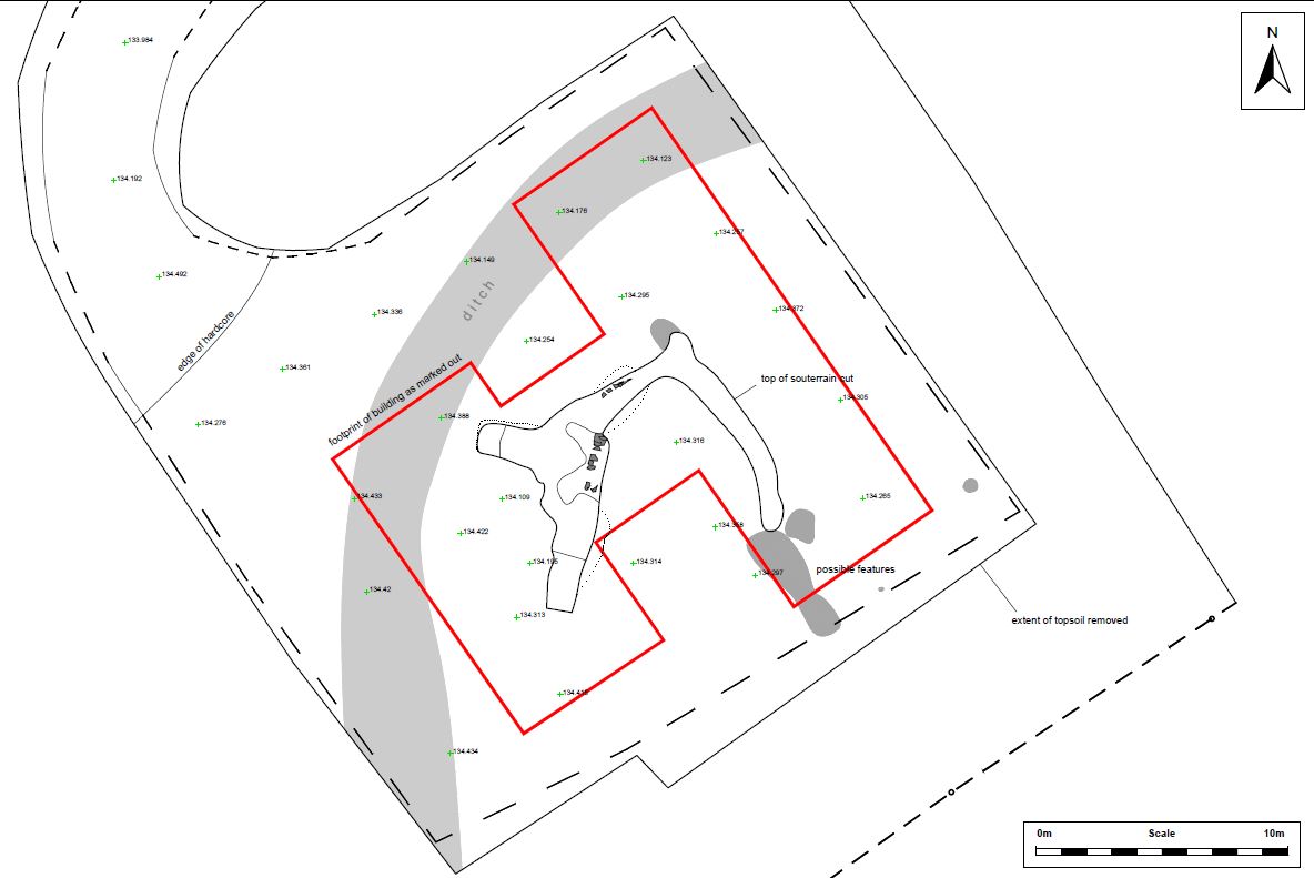
A souterrain was discovered by contractors during groundworks associated with the construction of a house. An associated enclosure was subsequently discovered through aerial photography and further investigative topsoil stripping on the site. The site was not subject to any archaeological planning condition and the discovery was reported to Tobar Archaeological Services by the contractors. The development consists of the construction of a single dwelling house on a green field site. The souterrain and associated enclosure were subsequently added to the record of monuments and places (CO071-159 and CO071-159001, respectively). The development site is located approximately 2km north-east of Macroom, Co. Cork, in the townland of Kill.
During the ground reduction towards the south end of the site a small cavity was noted in the exposed subsoil. Initially it was thought that this was a sinkhole and the cavity was subsequently widened by the machine. It then became apparent to the contractor and landowner that the ‘cavity’ was in fact a manmade feature/potential archaeological monument. All works on the site were halted and the discovery was reported to TAS by the contractor and client. An initial site visit was conducted by Tobar on 20 April 2015 in order to establish if it was in fact a monument, and the nature and extent of same, if possible.
The initial inspection recorded a barrel-vaulted earth-cut chamber measuring between 1.35m and 2m in width (east-west) by 3.5m in length. A ledge/step was apparent at the south end of the chamber and may have been stone-faced as some in situ and displaced stones were apparent here, particularly at the south-west. At the north end of the chamber a second step/ledge was apparent and leads into a shallow splayed recess blocked with drystone walling.
A meeting was held between the client, contractor, NMS and Cork County Council so as to decide how best to proceed. The following was agreed:
1. It was likely that the souterrain was located within a possible ringfort/enclosure (evident from the 2005 aerial photography)
2. The full extent of the souterrain would be defined within the site in advance of any further ground works
3. Removal of the earthen roof of the souterrain was the only means of tracing the tunnels safely and could be done with a machine under the strict instruction of an archaeologist
4. The remainder of the site would have to be cleared with a grading bucket to ascertain if any other archaeological features were present
5. If any other features are present they will be recorded, surveyed and preserved in situ
6. An instrument survey of the souterrain would be undertaken after its full extent was defined on the ground
7. No requirement for the excavation of the base of the souterrain would be necessary as it will ultimately be backfilled with stone and compressed and a raft foundation used for the house site.
8. Any other features noted within the site boundary would be recorded, surveyed and covered with terram before laying down stone.
9. Monitoring by an archaeologist would take place of any other ground works on the site and the subsequent recording of any features uncovered.
10. A report on the monitoring and survey work would be submitted to the National Monuments Services in accordance with the terms of the excavation licence.
The full extent of the chamber was surveyed having removed the roof. The remainder of the site was topsoil stripped which revealed a large enclosing ditch to the north of and enclosing the souterrain. Other potential associated features were also revealed and surveyed. The features were preserved in situ and the souterrain was backfilled with stone. A raft foundation was utilised on site to avoid impacting on the features.