2014:630 - DRUMGOLD 6, M11 Gorey to Enniscorthy Scheme, Wexford
County: Wexford
Site name: DRUMGOLD 6, M11 Gorey to Enniscorthy Scheme
Sites and Monuments Record No.: N/A
Licence number: E004581
Author: Graham Hull, TVAS (Ireland) Ltd
Author/Organisation Address: Ahish, Ballinruan, Crusheen, Co. Clare
Site type: Pit, Enclosure, Kiln and House - prehistoric
Period/Dating: Multi-period
ITM: E 699888m, N 638795m
Latitude, Longitude (decimal degrees): 52.491408, -6.529097
Drumgold 6 was located on the M11 Gorey to Enniscorthy Scheme, Co. Wexford. The site was in a large arable field that slopes gently down to the south and south-west towards a low-lying wetter area adjacent to the Drumgold Stream and an associated tributary.
The excavation revealed a multi-phase prehistoric, early medieval and post-medieval site.
Neolithic
A cluster of six pits contained sherds from 21 Early Neolithic carinated bowls. The pits occupied an arc 4m long and were 0.45-1.05m across and 0.13-0.35m deep. The neatly cut pits were oval or circular in plan and some of the pottery was seemingly carefully placed, suggesting structured deposition rather than simple waste disposal. This purposeful activity is further evidenced by the placing of parts of the same vessel in adjacent pits. The vessels were probably used in a domestic setting as most were fire-blackened or had blackened accretions likely representing burnt food. One of the pits was radiocarbon dated to 3650–3383 cal. BC (UBA-31901). Additional artefacts found within these pits were a sandstone possible anvil or unfinished perforated object, flint flakes, a convex scraper and a concave scraper.
A circular structure located at the west of the site was defined by seven post-holes with a diameter of 7.1m. No doorway was apparent but the lower density of features at the south might tentatively indicate an entrance here. Four other post-holes (or pits) may represent internal or roof-supporting features. Two sherds of Early Neolithic carinated bowl were found in one of the post-holes and a seemingly isolated post-hole or small pit located some 14m north of the possible structure also contained a sherd of Early Neolithic pottery. Although domestic structures in the Early Neolithic are almost invariably rectangular in plan, the circular structure at Drumgold 6 may represent a more transient building such as a store or an animal shelter. There is, of course, the possibility that the Neolithic pottery was residual and the structure is later in date.
Early Bronze Age
This period is represented by a ceramic vessel in a shallow pit, a cluster of stake- and post-holes and four radiocarbon determinations. The vessel comprises approximately one third of a well-made and elegant, decorated, bipartite vessel of the Vase Tradition. The vessel was found in a shallow pit near the centre of the site and is likely indicative of a disturbed burial. A sandstone (or arkose) rubbing or processing stone was found in the pit with the pottery.
Middle to Late Bronze Age
Enclosure
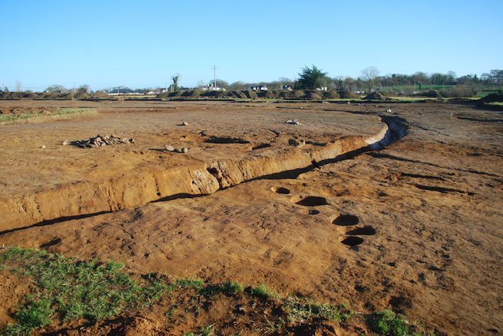
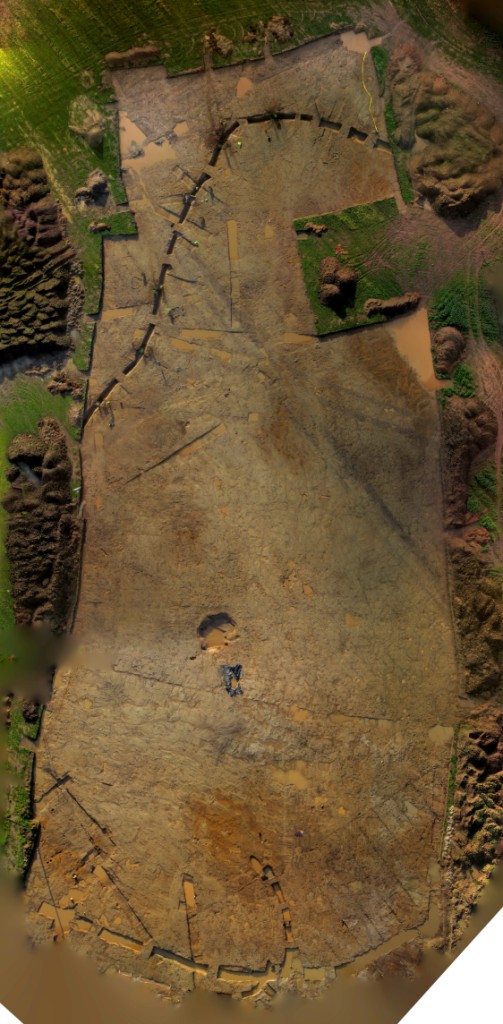
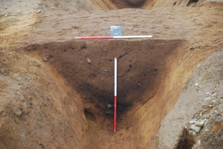
Geophysical survey and excavation revealed a sub-oval ditched enclosure measuring approximately 180m from north to south by 127m and enclosing approximately 1.77 hectares. The ditch itself was 1.35-2.16m wide and was in the range of 0.8m to 1.3m deep. Approximately 40% of the ditch circuit fell within the road-take, and 201.63m of a postulated total length of 500.5m length of ditch was excavated. An entrance to the enclosure, located at the north-east part of the site, was represented by a 2.6m wide break in the ditch with squared termini. The ditch was generally shallower and narrower at the south-east and had a typically ‘V’-shaped profile with a steeper inner edge. There was no direct surviving evidence for a bank but in places it appeared that the ditch fills had derived from initial slumping from the inside which suggests that there could have been an internal bank. There was limited evidence of a recut in parts of the ditch, but this was not consistent around the circuit and may simply represent an attempt at cleaning a partially infilled ditch.
A large assemblage (162 sherds) of Middle to Late Bronze Age pottery deriving from seven vessels was recovered from the enclosure ditch, concentrated in five locations. The pottery was generally bucket-shaped ‘plainware’ that likely had domestic origins as evidenced by fire blackening and blackened accretions that are indicative of cooking. This said, the end-use of the pottery may, given the similarities with the vessels deposited in the central pit (see below), have been as part of ceremonial or ritual events. The pottery dates from c. 1400 to c. 800 BC or even into the Iron Age until perhaps the 8th century BC. Four radiocarbon dates from the ditch gave a range from the early 16th to the late 10th centuries BC. Statistical analysis of the radiocarbon determinations suggests that the ditch was first in use between 1830–1655 cal. BC and went out of use between 1215–1020 cal. BC.
Pits and pottery
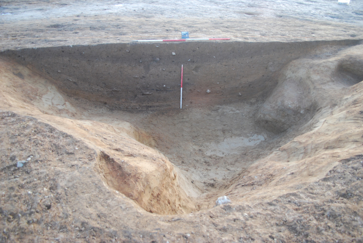
Centrally within the enclosure, and almost certainly contemporary with it, was a large pit cut into fine sand. This soft natural geology likely eased the digging of the particularly large pit that measured 9.4m by 7.4m and was 1.5m deep. The pit’s sides were inclined at 45 degrees or steeper and the base was flat and approximately 5.5m by 4.5m across. Nine fills were identified, some with large quantities of Middle to Late Bronze Age pottery, particularly in the primary fills. When open, the pit could easily accommodate a group of at least a dozen people standing or sitting. The pit might then have served as a ‘mini-amphitheatre’ for ceremonial activities such as the deposition of pottery.
Ten Middle to Late Bronze Age vessels were represented in the pottery assemblage from the primary pit fill and at least 45 similarly shaped and dated vessels were represented in the secondary fill and a possible recut, and lying on a dense layer of medium-sized stones. The pottery was in reasonably fresh condition with clean edge-breaks and little surface wear indicating that this was a structured deposit perhaps derived from an earlier dump or midden. The consistent quality, similar fabric and form of much of the pottery from the pit as well as the compact and localized deposition context indicate that the pottery was part of a deliberate depositional event. Further, the soft sand into which the pit was dug suggests a very short period of deposition—more an event than a process. Five further vessels were represented in later fills and this gives an impressive total of at least 60 vessels from the pit with a combined weight of over 28kg. As with the other Middle to Late Bronze Age pottery from Drumgold 6, the pottery from this pit is broadly typologically datable to the period between the 14th and 8th centuries BC and is essentially a ‘plainware’ with a bucket-shaped profile and sometimes broad and shallow channels alternating with broad and slightly raised ridges at the upper body. These channels and ridges may have allowed a firmer hand grip on these large and heavy pots. The pottery likely had an initial domestic function before re-use in a ritual or ceremonial event.
The total assemblage of Middle to Late Bronze Age pottery from the site had a combined weight of nearly 39kg and there were over 3,800 pieces representing approximately 84 vessels. Such quantities are only exceeded by the assemblages from Lough Gur, Co. Limerick, Rathgall, Co. Wicklow and Corrstown, Co. Derry (Roche and Grogan pers. comm.) Sherds from four Beaker period pottery vessels were also recovered from the secondary fill of the pit. These vessels are likely to predate the other vessels in the pit by approximately a millennium. It is almost certain that the Beakers were derived from another location and brought to the pit for deliberate, and presumably ritual, inclusion.
Four pieces of worked stone were recovered from the pit: a likely residual struck flint probably dating to the Late Mesolithic to Early Neolithic, two struck flints (a flake and a piece of debitage) and a quartzite hammer stone. The hammer stone was from an upper pit fill and exhibited intense pockmarking that testified to repeated use. It is very possible, given the perceived ceremonial use of the pit, that some of these stone artefacts were curated and purposely buried.
The analysis of the charred plant material from the layers of pit fills could support a ceremonial or ritual use for the feature as discrete burning episodes were evident: with the earliest fills dominated by oak, then deposits dominated by hazel, then oak and the final fill dominated by ash.
Radiocarbon dating was undertaken on four of the pit fills. The primary fill was dated from ash charcoal to 1500–1407 cal. BC, the secondary fill (where most of the pottery was recovered) was dated from unidentified charcoal to 1388–1128 cal. BC, a later pit fill was dated from hazel charcoal to 1490–1296cal. BC and the final fill was dated from ash charcoal to cal. AD 675–872. The three Bronze Age dates span the period from the very early 16th century to the early 12th centuries BC. The early medieval date from the final fill may have been the result of intrusive material in the soft deposit but could equally be from an isolated episode of burning in what may have been a slight depression in the old ground surface. The statistical analysis of the radiocarbon determinations from the pit indicate that it was most likely in use in the second half of the 14th century BC.
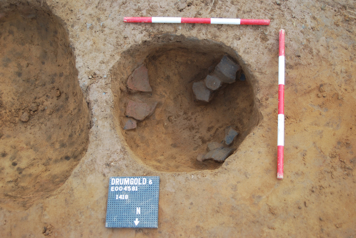
Six further, relatively discrete, pits from within the enclosure yielded either Middle to Late Bronze Age pottery and/or later Bronze Age radiocarbon dates. The pottery was similar to that described above and could span the period between the 14th and 8th centuries BC. One pit measuring 0.7m in diameter and 0.3m deep contained a single Middle to Late Bronze Age vessel, represented by 69 sherds. Such a large quantity of pottery within a relatively small pit indicates structured deposition rather than casual refuse discard. It should be noted, however, that some of the pottery from these pits was weathered, unlike that from the central pit.
Structures
Also likely contemporary with the enclosure ditch, central pit, and other pits, were the remains of a roundhouse. This circular feature was located near the centre of the enclosure and was defined by nine or ten post-holes, gullies and many stake-holes and had an external diameter of approximately 9m. The structure had an external circuit of evenly spaced post-holes that defined a near-circle with a post-hole centre to centre diameter of 7.2m. The south-facing entrance, 1-1.2m wide, was indicated by two post-holes that represented door-posts and a cobbled threshold set within a hollow inside a probable porch that was also 1-1.2m across. Within the building was an arc of five post-holes with a diameter of 5m that may represent further roof supports paired with some of those from the external circuit. Over 300 stake-holes and some smaller post-holes were also recorded, some likely representing an east to west wattle screen (reiterated several times) shielding the northern internal part of the building from the doorway to the south. A second wattle screen was apparent at the north-east of the door, again dividing the internal space of the building. External to, and concentric with, the structure was a number of shallow curvilinear gullies that may represent a drip-gully or, given the presence of stake-holes in the base, a wattle fence The gully was not present at the west and south-west and, given that this is the direction of prevailing wind, it is probable that truncation took place here destroying what is otherwise a very well-preserved building plan.
Three radiocarbon determinations were made and returned dates that overlap in the period between the early 15th and late 13th centuries BC. Statistical analysis of the radiocarbon dates suggest that the roundhouse was in use at the same time as the large central pit, in the period centred on the second half of the 14th century BC.
Single sherds of Middle to Late Bronze Age pottery were found in one of the post-holes in the external circuit and in the porch post-hole. These two sherds, and 20 sherds and smaller pieces found in the primary fill of the hollow at the porch, were from the same vessel. Sherds from two other similarly dated and weathered former domestic vessels were also recovered from the porch hollow. Also found within the hollow at the entrance to the building were a granite saddle quern and a flint that was a test-struck beach pebble. It is very likely that the sherds of the same pot found in three different features and the quern were deliberately placed as foundation deposits. A further struck flint that was a heat-affected and reduced beach pebble was found in another of the post-holes in the external circuit.
A second circular structure, defined by seven post-holes, was located near the centre of the enclosure. The structure had a post-hole centre to centre diameter of 5.6m and probably had a south-facing doorway represented by a post-hole and a shallow, stone-filled hollow or pit. A row of stake-holes aligned from east to west within the structure at the north-west suggested a wattle internal division. A pit of unknown function was recorded within the building. Two sherds from different Middle to Late Bronze Age vessels were found in two post-holes that would have held roof supports on the circuit of the building. Statistical analysis of the radiocarbon determinations from this roundhouse shows that this structure was in use in the 15th century BC—slightly earlier than the other roundhouse and the large central pit.
Early medieval
This period is represented by a circular structure, two recut cereal-drying kilns, two ditches perhaps forming a partial enclosure, a gully, a hearth and possibly a cluster of features within the partial enclosure.
The cereal-drying kilns were dated to the early 7th to late 10th centuries AD. The kilns were either oval or bowl-shaped in plan, although one was possibly keyhole-shaped with a fire-pit at the north-west end and a drying chamber at the south-east end. Some stone lining and possible baffle stones were seen. Laminated deposits of charcoal and oxidised clay testified to use on multiple occasions. Archaeobotanical analysis reveals that oat was the principal crop being dried on the site. Barley, wheat and rye were found in lesser quantities in most deposits within the kilns at Drumgold 6 implying that the local population had access to more than one type of cereal.
Adjacent to one of the kilns, at the south-west of the site, was a circular structure defined by a circular gully and presumed internal post-holes. No artefacts were found in these features, but radiocarbon dating suggests that the kilns are from the mid-7th to early 11th centuries AD and the structure dates to the period between the early 7th and late 10th centuries AD. The structure may well have had a domestic function and had a diameter of approximately 4.4m and a south-facing door. The recovered charcoal suggests a construction of oak and hazel. While morphologically similar to prehistoric houses, the circular structure is most likely to be early medieval in date.
A pair of curvilinear ditches were located at the north of the site and defined a ‘C’-shaped arc from south through west, to north and east. The ditches were 32m and 21m long, 0.88-1.65m wide and 0.55-0.89m deep and had ‘U’-shaped profiles. There was a 1.5m gap between the two ditches that likely represent an entrance. Both ditches had pronounced termini that strongly indicated that the semi-enclosure was as-dug and not truncated. There was no evidence for a bank associated with either ditch. A gully was also seen concentric to one of the ditches and may represent a palisade footing trench. Radiocarbon dating suggests that the ditches and gully were dug in the 7th to 9th centuries AD and remained open into the 10th to mid 12th centuries. A cluster of stake-holes, post-holes and pits was seen within the area enclosed by the two ditches and may represent related activity. No pattern was clearly discernible in the arrangement, but it is possible to identify a circle that includes four post-holes with a diameter of 5.6m that would be a reasonable size for a roundhouse.
Post-medieval
A heavily denuded, rectangular, stone-built house excavated at the north-east of the site measured approximately 8m by 5m and was oriented from north-west to south-east with a possible hearth at the north-west end. Artefacts associated with the probable two-room house and a nearby deposit of soil include domestic pottery dating from the 17th to 19th centuries an iron hammer head, a copper button and a coin dated 1689.
The archaeological features and deposits within the site were fully excavated and the excavated area was backfilled and reinstated.