2013:569 - FEIGHCULLEN, Kildare
County: Kildare
Site name: FEIGHCULLEN
Sites and Monuments Record No.: KD017-009
Licence number: 13E0156
Author: Ruth Elliott
Author/Organisation Address: 47 White Castle Lawn, Athy, Co. Kildare
Site type: Ecclesiastical enclosure and Field system
Period/Dating: Multi-period
ITM: E 672974m, N 720919m
Latitude, Longitude (decimal degrees): 53.233641, -6.906938
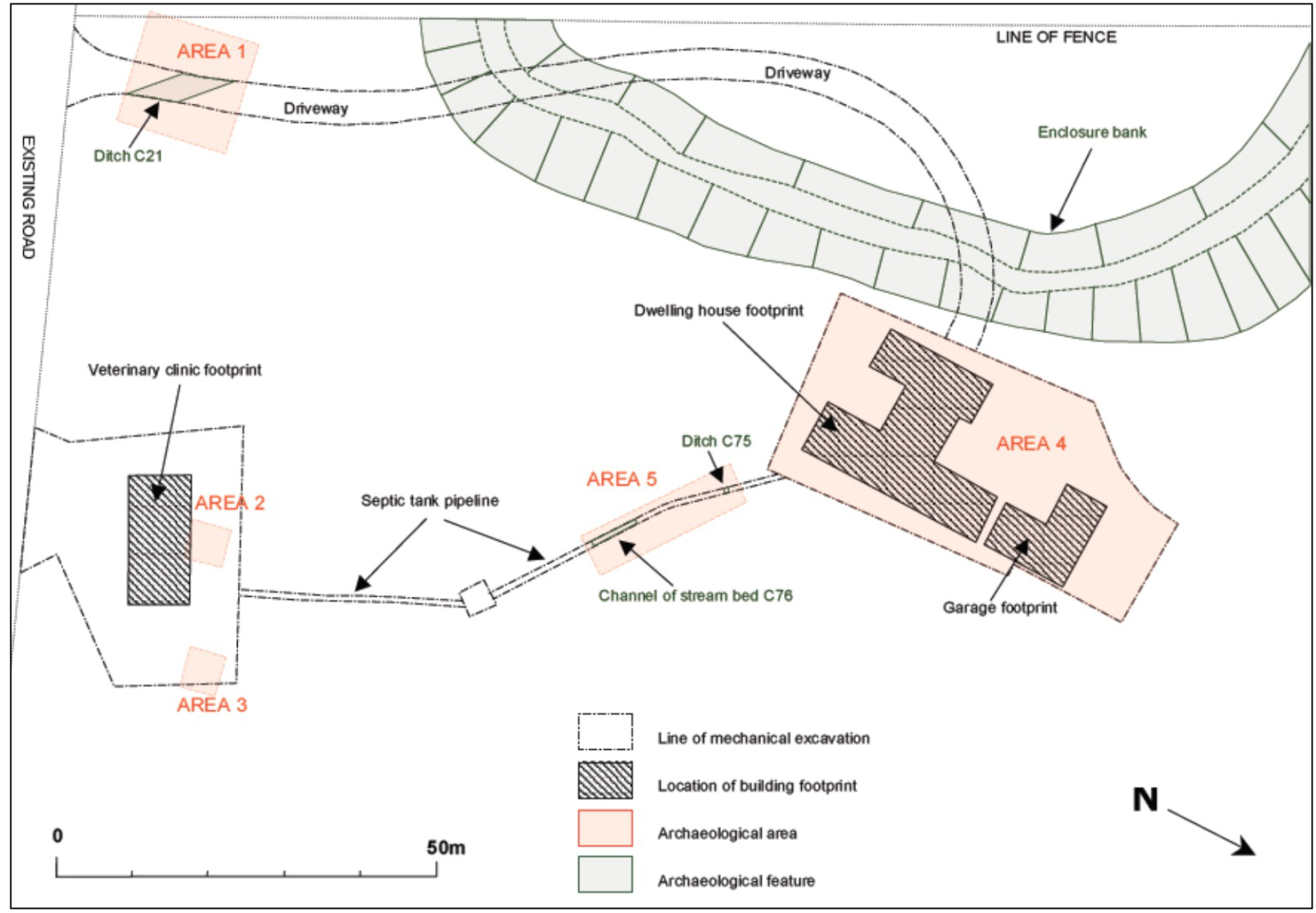
The site at Feighcullen, Co. Kildare lay adjacent to an ecclesiastical complex (KD017-009), comprising a 19th-century church, an early church site, graveyard, holy well, enclosure bank and possible medieval field system. Monitoring was carried out between 12 June and 5 July 2013 during groundworks for the development of a dwelling house, veterinary clinic and associated services. Extensive archaeological material was uncovered on the site, including burnt spread activity, iron smithing waste, pits, post-holes and ditches. The majority of material was preserved in situ and development plans were significantly altered to enable this.
The large enclosure bank entered the development area at the south-west and planning permission had been granted for the driveway of the dwelling house to cross it in two places. However, the bank survived on the site as a clearly visible standing archaeological monument. In response to this (and in consultation with the DAHG), a full record was made and impact avoided by ramping over the feature where the driveway crossed it. In addition to this, the intended location of the dwelling house was moved 4m east to avoid impact upon the monument. The full enclosure encompasses an area of 0.25km by 0.37km and is preserved in the landscape by a combination of field boundaries, road curvage, cropmarks and upstanding bank material. Within the development area it survived to a maximum width of 21m and height of 0.83m. The interior is much raised, suggesting a significant depth of archaeological material within it. It is constructed on dryland soils adjacent to peat bog (part of the Bog of Allen), now much drained, which would have added to the defensibility of the site. It is consistent with ecclesiastical enclosures of the Early Christian period.
Five areas containing sub-surface archaeological material were uncovered during monitoring:
Area 1
Area 1 comprised a broad linear feature, 3.2m wide and orientated north-north-east/south-south-west, located in the southern part of the driveway. This was consistent with a linear feature visible on aerial photograph. The feature was preserved in situ.
Area 2
Area 2 was situated in the location of the veterinary clinic. A cluster of eleven features were revealed in an area less than 5m by 5m. These comprised possible pits and stake-holes, most with a charcoal-rich content, suggesting a fire pit with associated support features. The cluster was not subject to impact and was preserved in situ, with the exception of a small charcoal spread (C16) which was fully excavated.
Area 3
Area 3 was situated in the location of the veterinary clinic, c.10m south of Area 2. It comprised a group of four visible contexts, including a possible pit or post-hole. These were not subject to impact and were preserved in situ.
Area 4
Area 4 comprised the entire footprint of the dwelling house, an area of approximately 25m by 60m and was located adjacent to the upstanding enclosure bank. It encompassed both dryland soils and drained peat bog. Forty-one individual features were identified during monitoring.
There was significant evidence of burnt spread activity in the lower lying areas to the north and east within the cutting. In a number of locations, the burnt spread material continued beneath a widespread peat deposit, C38, in the northern part of the cutting. A struck flint with a retouched edge and a fragment of burnt bone were found in association with one of these burnt spreads. A number of small features containing burnt spread material were revealed in close proximity, possibly representing related stake- and/or post-holes. Seven large circular, oval and sub-rectangular features throughout the cutting (most over 1m in diameter) may have represented troughs associated with the burnt spread activity.
Metalworking evidence was found in the northern part of the cutting, underlying the widespread peat deposit. This was partially revealed in a number of locations and comprised an extensive deposit, rich in iron slag and with moderate animal bone inclusions. Remains of a furnace base was identified, indicating successive episodes of iron smithing, however the absence of hammerscale or smithing pan fragments in the slag samples retrieved, suggested to specialist, McLaren, that the material represented a secondary dump or residual spread, rather than the location of an in-situ metalworking area. The metalworking area was unlikely to have been located too far from this waste material however, and the siting adjacent to widespread peat bog may have been related to obtaining bog ore (McLaren, 2013). The animal bones retrieved (including domesticated sheep and cattle) were likely to have represented basic food refuse (Lynch, 2013). It is possible that the metalworking is associated with the adjacent ecclesiastical site and a location outside the enclosure bank would support this theory, however a stratigraphic link was not obtained and in the absence of securely contexted dating evidence, the activity could date to any stage from the Iron Age onwards.
A feature cluster in the south-eastern part of the cutting was comprised mainly of post-holes, with post-pipe and packing fills visible, and may have represented the remains of a structure or various phases of a structure. This continued outside the limit of excavation and no coherent shape or form was apparent.
A series of ditches and linear features were revealed throughout the area. Two major ditches (C22 and C51) ran roughly parallel to one another in north-east/south-west slightly curving course and both appeared to underlie the peat deposit C38. A third ditch (C30) ran transverse to these and followed an undulating course. Both ditch C30 and C22 were sectioned during monitoring and revealed very similar depositional patterns, including a series of re-cuts. All three ditches appeared to correlate to earthworks visible on aerial photograph and were likely to have related to land drainage.
Development plans were altered for the construction of the dwelling house, replacing strip foundations with a pad foundation that allowed for the full preservation in situ of all archaeological material in the cutting. The peat layer C38 was left intact to act as an additional buffer zone.
Area 5
Area 5 was located within the septic tank pipeline. One ditch (C75) was found to cross the pipeline, possibly parallel to ditches C22 and C51. This was sectioned during monitoring works but not subject to further impact. Remains of a former stream bed were also found crossing the line of the septic tank.
References
Lynch, P. Animal Osteological Report. Feighcullen, Co. Kildare. 2013
McLaren, D. Feighcullen, Co. Kildare. Report on the vitrified material. AOC Archaeology Group, 2013.