2012:465 - KNOWTH, Meath
County: Meath
Site name: KNOWTH
Sites and Monuments Record No.: ME019-030
Licence number: C248, E4412, R294
Author: Fintan Walsh, Irish Archaeological Consultancy Ltd.
Author/Organisation Address: 120b Greenpark Road, Bray, Co. Wicklow
Site type: Building, Cultivation ridges, Field system and Pit
Period/Dating: Modern (AD 1750-AD 2000)
ITM: E 699673m, N 773543m
Latitude, Longitude (decimal degrees): 53.702059, -6.490471
A programme of testing was carried out at Robinson’s Yard Farm Complex, Knowth, Co. Meath. The work took place between 9 and 25 January 2012. The site is located within the constraints for the passage tomb complex of Knowth, ME019-030, which is within the UNESCO designated World Heritage Site boundary. The farm complex and Knowth House are also protected structures (MH019-117).
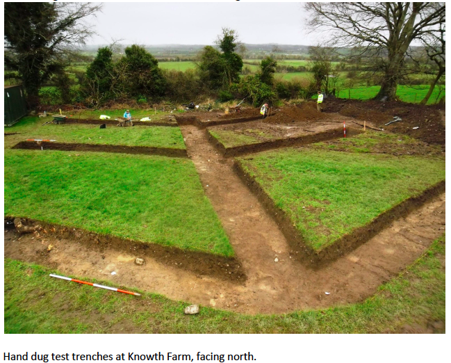
As part of the testing exercise, a total of 14 test-holes for service pipe trenches and structural engineer works, one test hole for a planned surface water soak pit, one test hole for a planned septic tank and 85m of test trenches within a percolation area were excavated. All excavations were carried out by hand and all excavated spoil and trenches were subject to metal detection.
Test hole excavations within and along the outer edge of the existing farm outbuildings (for service pipe trenches and structural engineer works) revealed that the levels of the upper and lower yard of the farm had been built up with imported soils and loose stone to accommodate the cobbled surface of the yard in the 18th and/or 19th century. The floor surface inside the buildings was built-up with compacted clays, some of which showed possible evidence of being subject to mixing with possible archaeological deposits (perhaps ash) suggesting that they may have archaeological significance. A possible cut feature was also identified at the northern end of a test hole for the service pipe trench which traversed the yard (Test Hole 12). It could not be established if this was of archaeological significance due to the restricted nature of the Test Hole.
A series of linear ditches were identified traversing the test holes for the planned surface water soak pit, septic tank and percolation area. One of these ditches contained a deposit of charcoal-rich soils in its primary fill and may be of archaeological significance. A tree-bole and large pit/ditch identified in this area may represent the remains of a removed field boundary depicted on historic OS maps. Finally, a series of ridge and furrows were identified at the southern end of the percolation area. These could not be dated during testing, however these types of features can date from the medieval period to the post-medieval period. No archaeological artefacts were recovered during the assessment.