2012:333 - WILLSGROVE/SALISBURY/SHANRAHEEN/TOMARD/SAWYERSWOOD/CLOGORROW/ARDMORE/SMALLFORD, BLACKWOOD/AGHANURE/ARDSCULL, Kildare
County: Kildare
Site name: WILLSGROVE/SALISBURY/SHANRAHEEN/TOMARD/SAWYERSWOOD/CLOGORROW/ARDMORE/SMALLFORD, BLACKWOOD/AGHANURE/ARDSCULL
Sites and Monuments Record No.: N/A
Licence number: 11E0460
Author: Faith Bailey, Irish Archaeological Consultancy Ltd.
Author/Organisation Address: 120b Greenpark Road, Bray, Co. Wicklow
Site type: Habitation site, Charcoal-making site and Burial
Period/Dating: Multi-period
ITM: E 672431m, N 697870m
Latitude, Longitude (decimal degrees): 53.026605, -6.920274
Monitoring was carried out as part of the River Barrow Abstraction Scheme (Contract 2), Srowland to Ardscull Rising Mains, which runs for c. 6.8km through the townlands of Willsgrove, Salisbury, Shanraheen, Tomard, Sawyerswood, Clogorrow, Ardmore, Smallford, Blackwood, Aghanure and Ardscull, Co. Kildare. A total of five archaeological sites were identified and excavated during the course of works.
Willsgrove 1 consisted of three areas of activity. Areas A and B contained the remains of burnt mound-related activity, whilst several pits were identified in Area C. In Area A, a rectangular trough was excavated. Fourteen stake-holes were cut into the corners of this trough, two in the south-west corner, one the north-west corner, five in the north-east corner and six in the south-east corner. These are thought to have held a wooden plank lining within the trough. Several smaller pits were excavated surrounding the trough, although the purpose of these was unclear. A large field boundary to the south-east of these features may have removed further cut features. A large amount of burnt stone was mixed in with the fill of this field boundary suggesting it had disturbed a burnt mound which may have overlain these features. Charcoal was also obtained from the fill of the trough. This was identified as hazel and was sent for AMS Radiocarbon dating. It returned a 2 sigma calibrated date of 919–803 BC, placing the feature in the late Bronze Age/early Iron Age.
In Area B, a further trough and possible well were identified. The trough also had a number of stake-holes on its corners. It was an unusual shape and may have been formed from two troughs, one cutting the other, however the fills were identical and the features were thought to be the same. The well feature to its west held water throughout the excavation. The lack of an obvious water source in the area may have made it necessary to excavate a large well-type feature in order to fill the trough. Charcoal was also obtained from the basal fill of the well. This was identified as Pomoideae charcoal (relating to fruit trees, such as apple) and was sent for AMS Radiocarbon dating. It returned a 2 sigma calibrated date of 970–805 BC, thus placing the feature in the late Bronze Age/earlyIron Age. It is likely that the very similar dates obtained from Areas A and B indicates that the activity is contemporary.
Area C contained several small pits and a larger probable charcoal clamp. These were scattered over a relatively large area. The smaller pits may relate to prehistoric, medieval or post-medieval activity. However, charcoal was obtained from the fill of the charcoal clamp, which was identified as Pomoideae charcoal (relating to fruit trees, such as apple). This was sent for AMS Radiocarbon dating and returned a 2 sigma calibrated date of AD 1298–1407, which places the feature firmly in the medieval period. It is possible that this particular feature relates to similar activity identified at Salisbury 1, c. 375m to the east.
Salisbury 1 contained three charcoal-production pits. They were all similar sizes, showed evidence of in situ burning, and contained black sandy silt fills. They were initially thought to all be contemporary. Charcoal was retrieved from both of the fills of the two slightly smaller clamps and was identified in order to obtain dates for the features. The 2 sigma AMS radiocarbon dates that were returned were AD 897–1026 and AD 895–1018 suggesting that the early medieval features are likely to be contemporary. A further date was obtained for the slightly larger clamp. This returned a 2 sigma AMS radiocarbon date of AD 1190–1276, dating the feature to the medieval period. The date was slightly earlier than that of the clamp within Willsgrove 1. It is interesting to note that the road junction to the north of Salisbury 1 is referred to (in modern maps) as the ‘Burnt Tree Cross Roads’. However, no crossroads is shown here on any map edition, only a junction. It is possible that this name relates back to the land use in the area and more clamps are located outside of the pipeline wayleave.
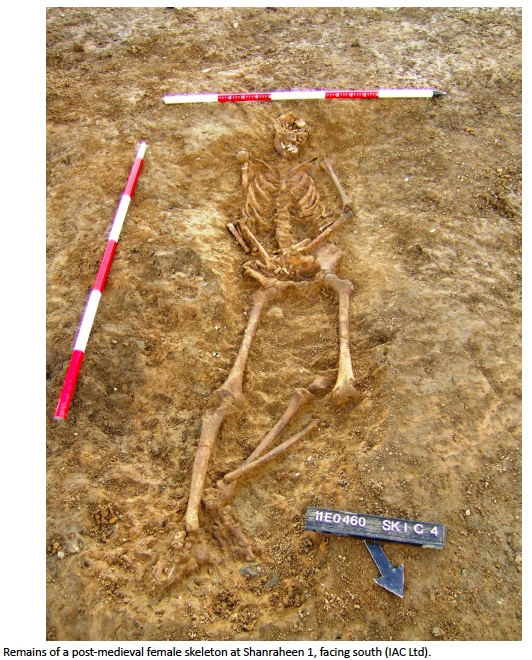
Shanraheen 1 consisted of a single human inhumation and two isolated pits. The skeleton was located to the immediate north of the local road and was aligned north-south, with the head pointing to the south. It was laid out in an extended, supine position with both arms slightly flexed across the body. The left leg was flexed at the knee while the right leg was straight. The remains occupied a ‘scrape’ in the ground, rather than a proper grave cut. This had been truncated by modern ploughing in the area. The remains were identified as belonging to a young adult female (19-25 years). The cause of death was not obvious from the skeletal remains. However, it appeared that little care had been given to her placement in the ground. A sample of fibula was sent for radiocarbon dating and returned a 2 Sigma date range of AD1459–1637 placing this burial in the later medieval or early post-medieval period. It is not clear as to why this young woman was not interred in a graveyard during this period and it is possible that she was a victim of an undiscovered crime.
The isolated pits were located to the west of the burial. Both were oval and showed evidence of in situ burning with charcoal-rich fills. These have been interpreted as possibly being post-medieval in date and associated with scattered settlement along the road, which is marked on the first edition OS map (1837).
Ardmore 1 contained three pits, which were located to the immediate east of a small river. These have been interpreted as charcoal-production pits. Two were circular and one was oval, all were very shallow and displayed evidence of in situ burning and contained charcoal-rich fills. Charcoal from one of the pits was identified and sent for dating. This returned a 2 sigma AMS radiocarbon date of AD 897–1021, dating the feature to the early medieval period.
Ardscull 1 was the most easterly of all the sites excavated on the scheme. It consisted of 13 pits, two spreads and a single post-hole. These were scattered across a large area. During the excavation the date of the pits was not clear as no artefacts were recovered and no clear pattern was identified to suggest structures. Therefore three dates were obtained for the features. One pit returned a 2 sigma calibrated date of AD 782–978, dating the feature to the early medieval period. Two other pits returned dates of AD 1414–1474 and AD 1486–1644, providing medieval and medieval/early post-medieval dates. The lack of medieval finds at the site, or domestic refuse, would suggest that settlement was not located within the immediate vicinity of the pits. It is possible that they relate to agricultural or industrial activity such as charcoal production.
No other archaeological features were identified within the wayleave of the pipeline during monitoring