2012:303 - BRAY, Valentia Island, Kerry
County: Kerry
Site name: BRAY, Valentia Island
Sites and Monuments Record No.: KE087-067
Licence number: 12E0147
Author: Aidan Harte, Munster Archaeology
Author/Organisation Address: Ballymacredmond, Butlerstown, Bandon, Co. Cork
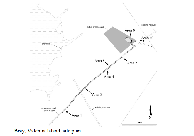
Site type: Field system and Hut site
Period/Dating: Prehistoric (12700 BC-AD 400)
ITM: E 434619m, N 575576m
Latitude, Longitude (decimal degrees): 51.907343, -10.403299
Excavation ahead of construction of an Air Monitoring Facility was carried out between June 5 and August 8, and again between November 10 and December 18, 2012. This was undertaken within a pre-bog field system (KE087-067), previously recorded by Frank Mitchell (1989), and a hut-site 30m south of the excavations was previously excavated by Alan Hayden under license 94E0120 (Excavations 1994, No. 119).
Testing had previously been conducted here by Niamh O’Callaghan under license 10E0190 (Excavations 2010, 373), and subsequently the entire area was monitored—an extent of 4.45ha. Following this, ten areas of archaeological interest were excavated and are summarised here from south-west to north-east.
Area 1 was a pre-bog drain cut. The drainage ditch traversed the road-take, south-east/north-west, and was U-shaped in profile, 1.5m wide, 0.6m deep. The next area (Area 3) uncovered a pre-bog field boundary orientated east-west; a length of 5.08m was exposed. The wall measured 1.9m wide and was only 0.25m in height. Clusters of natural quartz pebbles were found beneath the wall. Further down-slope (Area 4), a previously recorded wall (Mitchell’s [1989] wall No. 11) was orientated east-north-east/west-south-west. The peat had not been cut-away as it had elsewhere and a pre-bog field wall of collapsed upright slabs was found set on a plinth of smaller stones on either side: width 1.92m, surviving height 0.6m. Five meters to the north-east, a portion of curvilinear slot trench was found (Area 5). Approximately 1/3 of the probable structure was within the excavated area. The slot was U-shaped in profile, 0.53m wide with steep sides to a base, 0.2m deep. There was evidence of packing within the fills. Area 7 covered an intersection of pre-bog walls where two large walls were found (previously noted as wall No. 12, Mitchell 1989),. The first, orientated west-south-west/east-north-east, was composed of large boulders and was faced on either side by smaller stones; it was 2.35m wide and 0.5m high. This was exposed over a length of 9.1m but did not join the other wall at the east. The second wall was of similar form (0.48m high, 2.3m wide) but had been altered significantly through use. This wall was dismantled at its south-east end but 11.2m was exposed. A small hearth was found in situ beneath a collapsed upright, on what would have been the top of this wall. Two further small sections of secondary walls were also identified as alterations. The second wall extents north outside of the area of excavation and was intersected again (Area 9). Here, the wall was poorly preserved and measured 2m wide by 0.19m in height; exposed for a length of 4.8m. It was again intersected where a utilities trench (Area 10) was inserted at the north-east. A further two pre-bog walls were also found here. While one was very poorly preserved, the other was of the same form as the wall in Area 4, and was seemingly connected to a wall at north (Mitchell’s wall No.13). Three areas (2, 7 and 8) were not archaeologically significant.
Only five artefacts were recovered, all lithics. These were debitage and one broken scraper—preliminary analysis dates these date to the late Bronze Age. Over 90 samples of soil and wood were recovered and a programme of environmental analysis and radiocarbon dating is planned.
Reference:
Mitchell F. 1989. Man & Environment in Valencia Island. Royal Irish Academy, Dublin.