2012:163 - BANGOR: Servant’s Hill (Ballymagee), Down
County: Down
Site name: BANGOR: Servant’s Hill (Ballymagee)
Sites and Monuments Record No.: N/A
Licence number: AE/12/122
Author: Fintan Walsh, Irish Archaeological Consultancy Ltd.
Author/Organisation Address: 120b Greenpark Road, Bray, Co. Wicklow
Site type: Excavation - miscellaneous
Period/Dating: Multi-period
ITM: E 751539m, N 880275m
Latitude, Longitude (decimal degrees): 54.647862, -5.651860
A research excavation was carried out at Servant’s Hill, Bangor, which follows on from a geophysical survey undertaken at the site by Joanna Leigh (Licence Ref.: AE/12/99). Excavation was carried out as part of the DCAL Ulster Scots Archaeological Services (Project 7479) survey into the Ulster Plantation 1600–1650. Five cuttings were excavated between 18 September and 19 October 2012. These cuttings were strategically located to investigate the main geophysical anomalies.
The area of excavation is shown within the historic mapping resource as containing a number of structures. Thomas Raven produced a map of the Hamilton estates in north County Down in 1625 showing four houses occupying rectangular plots in the south-western corner of the townland of Ballymagee. Today, a portion of the western part of that area is now occupied by part of a large shopping centre.
This project forms part of a larger programme of work being undertaken by the Ministerial Advisory Group for the Ulster Scots Academy (MAGUS). This commission deals specifically with the physical remains, material culture and documentary historical evidence for the Ulster Scots during the early Plantation period (1600–1650) and the preparation and publication of a comprehensive archaeological survey and landmark publication that covers evidence for this pivotal period in the history of Ireland.
Cutting 1 measured 10m x 5m and targeted GA A (curvilinear anomaly) and GA 1 (possible structural remains). The possible structural remains anomaly highlighted in the geophysical survey was found to be a relatively regular area of gravels against a backdrop of natural sands. There was no indication of structural remains in this trench. Two irregular strands of hardened clay orientated south–north, central to the cutting, which were tentatively interpreted as wall footings early in the excavation, were subsequently found to be naturally occurring clays. One archaeological feature, a ditch, was identified at the western end of the area. This was orientated north-north-east/south-south-west and measured 0.55–1.3m wide and 0.3m deep. No finds were recovered from this feature and therefore it cannot be dated, however, it is possible that it could be the remains of one of the linear boundaries depicted on the Raven map.
Cutting 2 measured 10m x 2m and targeted GA A (curvilinear anomaly) and GA 2 (possible structural remains). Cutting 2 was aligned perpendicular to Cutting 1 across another area of high resistance, which again was found to represent an area of compacted gravels. These are likely to be naturally occurring but might tentatively be the remains of a compacted surface, perhaps a yard area. One subsoil-cut feature (a linear gully) was identified at the southern corner of Cutting 2. Cutting 2 was extended slightly in a 1m by 1m block to further investigate this feature which was found to extend beyond the cutting to the south. The gully was 1.5m long (to the edge of excavation), 0.46m wide and 0.2m deep. It contained two fills, the lower containing some small quantities of charcoal, which was sampled for analysis. It is possible that this is a wall foundation for a building/house.
Cutting 3 measured 10m x 2m and targeted GA C (possible linear ditch) and GA 4 (possible field boundary). This cutting contained six pits and a large irregular cut/ditch. The pits were cut into soft sands and had similar sandy fills. The pits were generally 1–1.3m wide and up to 0.45m deep. One pit produced two fragments of possible 17th-century pottery. The large irregular cut/ditch was aligned north–south at the very eastern end of the trench. This was 2.5m wide and up to 0.64m deep. It extended across the width of the cutting. The edges of this cut were very irregular and the fills were sterile clays, sands and gavel. The main fill was homogenous compacted clay, similar in colour and composition to the hardened clay in Cutting 1. It is difficult to interpret this feature further due to the sterile nature of the fills and the lack of finds; however it does seem to correspond to the large linear anomaly highlighted in the geophysical survey which traverses this part of the site.
Cutting 4 measured 10m x 2m and targeted GA 3 (potential archaeological remains – structural?) and GA E (curvilinear trend). This cutting was located at the very edge of the existing north–south-orientated field boundary which was characterised by a ditch on its eastern edge. Cutting 4 extended to the eastern edge of this field boundary ditch and contained one feature of note relating to this boundary. This was a possible ditch, or cut/exaggeration of the natural slope of the field. This cut was at the western end of the trench extending 3.52m into the cutting and was a maximum of 0.6m deep. A series of sandy clay fills were recorded backfilling the cut including, most notably, two deposits of ashy, charcoal-rich soils with heat-affected stones. No finds were recorded from these deposits, however samples were taken which should provide good environmental and datable material.
Cutting 5 measured 8m x 4m and targeted GA D (cluster of possible pits or burnt spread material). This cutting was located on a relatively flat plateau and was positioned to investigate a large group of circular anomalies (pits) depicted in the geophysical survey. Cutting 5 contained the greatest concentration of archaeological features of the five investigation areas. Central to the archaeology here were two large pits/depressions measuring c. 2.7m diameter by 0.2m deep and c. 2.5m diameter by 0.25m deep respectively. Both these features were characterised by dark, charcoal-rich fills which produced coarse prehistoric pottery and lithics including a possible flint arrowhead.
A series of post-holes were uncovered throughout the cutting including a distinct curvilinear line between the larger pits. These were on average 0.1m wide and 0.1m deep. They may represent the outline of a circular building with perhaps the larger of the pits at its centre. Other smaller pits and dispersed post-holes were encountered at the eastern end of the trench, all of which contained similar fills of lightly charcoal-flecked sands, none of which contained any in situ packing or post-pipe remains.
At the south-western corner of the cutting a linear foundation trench extended north–south across the cutting for 1.75m. This was on average 0.4–0.6m wide and on average 0.2m deep. This foundation trench contained a distinct packing material either side of a charcoal-rich seam (perhaps representative of a decayed and/or burnt series of planks). Six individual post-pipe settings were also recorded within the foundation trench. These were charcoal-rich and are likely to indicate the location of posts which were burnt in situ. Foundation trenches of this type are typical of early Neolithic houses and it is possible that this is a part of such a building, the focus of which may be outside the limits of the cutting, to the south-west.
Features from this cutting were extensively sampled for environmental analysis and radiocarbon dating.
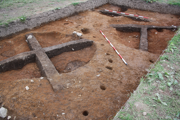
Remains of possible prehistoric structures at Servant’s Hill, Bangor, facing north-east.