2012:098 - CAHERDUGGAN NORTH/CLOGHEEN/KILMACOOM, Cork
County: Cork
Site name: CAHERDUGGAN NORTH/CLOGHEEN/KILMACOOM
Sites and Monuments Record No.: N/A
Licence number: 11E071
Author: Colm Moloney, Rubicon Heritage Services Ltd.
Author/Organisation Address: Unit 1, Wallingstown Business Park, Little Island, Co. Cork
Site type: Excavation - miscellaneous
Period/Dating: Multi-period
ITM: E 557141m, N 605558m
Latitude, Longitude (decimal degrees): 52.200136, -8.626972
Rubicon Heritage Services Ltd was contracted by Cork County Council to undertake archaeological works in advance of the construction of the R581 Doneraile to Newtwopothouse Road Realignment. The route traversed a rich archaeological landscape which was intensively occupied from the early medieval period up to the post-medieval period. Although the route traversed eight fields, the majority of archaeology was identified in Caherduggan North townland in Fields 3 and 4.
Field 1
A single large post-medieval pit was identified.
Field 3 and 4
Multi-period activity was identified at this location.
Phase 1: Early – Middle Neolithic
A circular enclosure was identified defined by a narrow and shallow ditch which was partially contained within the road corridor. This was radiocarbon dated to the Early – Middle Neolithic transition.
Phase 2: Early Medieval
A scatter of features was identified in Field 4 which may represent extra-mural activity associated with the ringfort (CO025-012002) which survives as an earthwork in Field 3 to the north of the road alignment.
Phase 3: High Medieval
A large ditch was identified running parallel to the river that formed the boundary between Fields 3 and 4. This was roughly contemporary with a large well identified in Field 3 which contained a number of leather objects including a horse harness complete with heraldic shields. Evidence was also identified for the possible location of a defended enclosure in Field 3 which later developed into a tower-house.
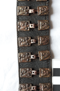
Horse harness from Caherduggan North/Clogheen/Kilmacoom
Phase 4: Early post-medieval
The majority of archaeology identified in the area dates to the early post-medieval period. This appears to be centred on a stone tower-house identified in Field 3 which was surrounded by a large revetted fosse. A contemporary enclosure was identified to the west and an unenclosed cluster of circular post-built structures was identified to the north-east in Field 4.
Field 5
Evidence was identified for early medieval iron working, an early post-medieval enclosure and the remains of a possible 18th- or 19th-century vernacular structure and related property boundaries.
Field 6
A number of linear features were identified in Field 6 comprising a number of field boundaries and agricultural linear features. As well as the linear features two hearths, a possible post-hole, a shallow pit and a charcoal spread were also identified.
Field 8
The findings in Field 8 show a number of linear features, identified as modern field boundaries, and a few isolated pits, post-holes and a medieval hearth.