2012:086 - TULLA: St Mochulla’s Church, Fair Green, Clare
County: Clare
Site name: TULLA: St Mochulla’s Church, Fair Green
Sites and Monuments Record No.: CL035-02201
Licence number: C361, E4041, R187
Author: Franc Myles, Archaeology and Built Heritage
Author/Organisation Address: 79 Queen Street, Smithfield, Dublin 7
Site type: Excavation - miscellaneous
Period/Dating: Multi-period
ITM: E 548882m, N 680189m
Latitude, Longitude (decimal degrees): 52.870168, -8.759269
Introduction This summary details the preliminary results of an excavation undertaken in a small (c. 0.16ha) field within and part-bounded by the enclosure of an early 7th-century ecclesiastical foundation associated with St Mochulla. The excavation took place from 7 February to 13 April 2012, with a two-week break taken in late March due to inclement weather. The excavation and post-excavation work have been funded by Tulla Parish Council.
The enclosure surrounds a hilltop, just over 80m above OD, which is dominated by the recently-conserved ruin of a protestant church constructed after 1702. This appears to have replaced a medieval parish church, which possibly dates from the late 14th-century endowment of extensive lands in the area by Macon MacNamara (Westropp 1911, 13). Prior to its conservation as a ruin, the 18th-century church was subject to two brief seasons of excavation (Myles 2008 and 2009, Excavations 2009, No. 106). This structure had fallen into disrepair by the turn of the 19th century and was replaced by a Board of First Fruits church in 1822 on the western edge of the village, which was itself demolished in 1965.
The area immediately surrounding the church and extending out to the south has constituted the parish graveyard for centuries. The graveyard expanded incrementally to the south and east in the early 20th century, with a modern graveyard (developed c. 1975) occupying most of the northern area of the enclosure. This is separated from the older graveyard and church ruin by a laneway of some antiquity, which bisects the enclosure from the south-west to the north-east. Two sections of a masonry wall footing survive on the southern side of the lane below the present wall defining the older graveyard, where the northern terminus possibly represents the north-eastern corner of the medieval parish church.
The south-western quadrant of the enclosure is occupied by the Fair Green and is presently a landscaped car park, with evidence of the enclosure ditch perhaps surviving as a break of slope over a grassed area. To the south of the enclosure, a holy well dedicated to St Mochulla occupies a small area off a laneway enclosed in recent years by a masonry wall composed of architectural fragments from the graveyard on the hill above.
The excavation under discussion was undertaken after a programme of geophysical prospecting and test trenching proved inconclusive (Thébaudeau 2009, Myles 2012). Apart from its location within the ecclesiastical enclosure, morphological analysis suggested the likelihood that a portion of the area investigated may lie within an inner enclosure, a section of which still survives to the north-east of the standing church represented by a break of slope.
Excavation
The field was initially stripped mechanically with a grading bucket in 3m strips moving downslope from the eastern boundary within the existing modern graveyard. This removed the disturbed topsoil which had been churned over by the horses paddocked in the field for over 20 years. The soil was stockpiled along the western boundary of the site over a 5m buffer zone, which was not investigated. This precluded an investigation of the vallum, the principal enclosure surrounding the site, which is possibly prehistoric.
This operation exposed the upper surface of what was initially interpreted as the dóib bhuí (the local name for the subsoil) with several cut features made obvious by the colour differential of the fills. The investigation was thus conducted as an open plan excavation and three principal phases of occupation were identified. Phase I relates to the cutting of an enclosure ditch and the tentative evidence for the construction of a platform around the church revetted in stone; Phase II relates to evidence for the subdivision of the site by means of a ditch; Phase III relates to the 19th-century occupation of the site and the construction of the cottage and associated rubbish pit and drainage features.
Phase I: the enclosure ditch, F50
The earliest features recorded comprised an inner enclosure ditch, presumably associated with the earliest church on the site, a tantalising glimpse of a stone-revetted embankment possibly creating a level platform for the early church on the summit of the hill and a fragment of a circular hut structure with a central post. The presence of a large curvilinear ditch across the site was not evident on the initial topsoil strip and it was only detected on investigation of the edges of a Phase II feature, which cut through the upper fills. It has been interpreted as an inner enclosure of the early church, however a more considered interpretation awaits the results of 14C dating from several samples taken from the lower fills.
Cutting the dóib bhuí, the ditch extended for some 35m across the site, with an average width of 2.6m at its widest against the northern boundary of the site, narrowing to 1.25m towards the centre of the site and widening again to 1.82m at the southern edge of excavation. Seven sections of the ditch were excavated, leaving six baulks across the feature in situ. Its edges were steep and regular and despite the redeposited nature of its upper fills, they were relatively easy to follow once the feature was identified. The ditch had a flat base and was generally between 0.75-1.45m in depth. Its profile in section indicated a more vertical outer edge, with a longer inner slope. This differentiation in slope was less pronounced as the ditch curved around to the north where the natural gradient was more benign. There was no evidence recorded for a palisade which would suggest the function of the feature was symbolic rather than defensive.
There were three principal fills recorded in the ditch. The earliest fills comprised deposits of silt which had presumably accumulated when the ditch was functioning. The lowest fill, F49, comprised a light grey silt, mottled with charcoal flecks, which survived to a depth of between 0.2-0.3m. This was recorded in all of the sections excavated and found to be slightly deeper towards the northern end of the feature. Several charcoal samples were taken for further analysis.
This material was sealed by F48, a slightly lighter silt recorded at the northern and southern limit of excavation, but absent towards the middle where F49 was less evident. The silt was between 0.15-0.25m in depth and was recorded lipping against the sides of the cut. This fill was slightly grittier than the material above and below, however there was a similar frequency of small pebbles. Again there were charcoal flecks present and samples were collected for further analysis.
A third silty fill, F47, was pinker in hue, with a more obvious horizon with F48 below. The fill was again more evident in the northern and southern extremes of the cut, however it was present in section towards the centre of the feature as excavated. Again, there was charcoal present which was collected for further analysis. The interface of F47 and the main fill above, F46, produced the one significant find of the excavation. This was a rotary sharpening stone, with a diameter of 125mm, tapering to 120mm and a thickness of 800mm. A square-shaped perforation 44mm across was somewhat off-centre, perhaps indicating an elongated period of usage. Where one surface was flat, the other side was uneven and the stone had probably been broken prior to its deposition in the ditch. The find was recovered from the very southern limit of excavation against the section.
There was no evidence that the silts had been disturbed by means of a recut. Where the horizon between F47 and F46 was slightly concave in profile, this has been interpreted as a function of the softer material below rather than evidence for a recut.
The principal fill, F46, was made up of redeposited subsoil with the occasional small boulder present. In plan, there was no obvious differentiation between the fill and the dóib bhuí extending out to the west downslope. A site inspection undertaken in October 2012 after a period of heavy rain did however demonstrate a slight variation between the fill remaining in situ and the subsoil, where the latter was only slightly stonier. On excavation, the F46 material was virtually indistinguishable from the subsoil, however the edges of the ditch were slightly more compact and the interface with the fill was occasionally slightly sandier.
This material formed the principal fill of the ditch and is presumably derived from the upcast washing back in, or perhaps being deliberately redeposited to level out the ground. In this regard, an examination of Westropp’s survey appears to show a dark line extending along the approximate southern extent of the ditch as excavated, with a break in the slope at either side as indicated by differential hachuring. It is likely therefore that the ditch had something of a physical presence on the surface of the field on by the turn of the 20th century, where Westropp, having already recorded the remains of enclosure to the east of the church, would certainly have noticed a more obvious cut feature had it survived. In any event, the fact that three later drains terminated along the line of the ditch would suggest that despite its invisibility, it retained a drainage function long after it had been backfilled.
At the time of writing, the design of the graveyard extension is being amended to provide for a curvilinear path over the ditch, to mark its presence below.
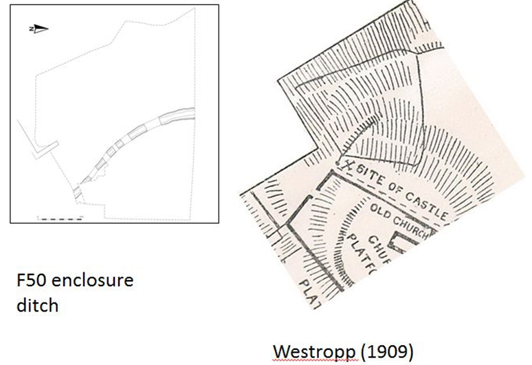
St Mochulla’s Church, Fair Green, Tulla, Westropp’s plan and plan of F50 compared.
F45 bank? and platform
There was ephemeral evidence for an internal bank to the east of the central portion of the excavated ditch. This was no more than 0.25m in height, extending for 3.5m along the inner cut which tapered off into the natural gradient to the east. Again, there was a difficulty distinguishing this material from the underlying subsoil and it is equally possible that the feature is simply a function of the micro-topography of this part of the site.
Similarly, the extent to which the surface uphill from the ditch constitutes a formal platform could not be definitively established by excavation. Two sondages cut to investigate this possibility added to the evidence from sections provided by later cut features; they tentatively suggest a thin (c. 0.15-0.3m) coverage of redeposited material across this area. This could also however be explained by geological considerations and moisture penetration from above.
Again, Westropp’s survey does not suggest that this area was significantly flatter and the hachuring annotated on the plan suggests a similar gradient to that on the far side of the church and in the modern graveyard to the north.
F13 revetment structure
A 3m-wide sondage was opened through F4, the stone-revetted earthen bank at the eastern limit of excavation, to investigate for dating evidence of the boundary and check for the break in slope recorded 7m further south-east in Test Trench 3. This had previously been interpreted by the writer as the edge of the church platform as identified by Westropp. The bank itself will remain in situ in the development, however it will be covered over with soil to form a new bank with a gentler gradient to represent the platform and to differentiate the 1970’s graveyard from the new development.
Cutting the subsoil was a linear arrangement of stones, F13, along the same alignment as the field boundary above. It was cut by F7 to the south in the section of the sondage and extended north-north-west for 5.2m into the main area of excavation. It is likely that the feature was cut at this point by a Phase II drain, however this was not ascertained due to the possibility of collapse from the F5 material within the revetted field boundary immediately above. In plan the stone alignment measured 1.2m across, widening to 1.6m at its southern end. A section 1.4m in width was excavated across the southern extent of the feature and the observations below relate to this area only.
The earliest feature recorded in the sequence was a deposit of fine orange silty clay, F55, which extended east into the baulk and to the north, under the F4 field boundary above. Its southern and western extents appeared to be delineated by the F13 stone alignment and it is likely both are related. It was however obvious that the upper level of the deposit was rising in the sections to the north and east, perhaps indicating a sudden rise in the level of the underlying subsoil similar to that recorded in Test Trench 3. Although the deposit remains unexcavated, the adjacent levels to the west would suggest that the material is heat-scorched in situ subsoil and the large charcoal flecks present (which may constitute contamination from the material above) were sampled for further analysis.
This material appears to have been cut by a flattened ovoid pit, F54. At its narrowest in the west-facing baulk it was 1.01m across, where a projected east-west extent measured 1.8m. It was 0.3m in depth with gently sloping sides to a relatively flat base. The northern side of the cut continued outside the area excavated, presumably to hold the stones filing the feature.
A lower fill, F53, was only encountered in the western side of the cut. The frequency of large stones over the area disturbed the stratigraphical relationship of the localised deposits and the material may be intrusive. This comprised a grey-brown silty clay with infrequent flecks of charcoal.
Occupying the main area of the pit was a loose, black silty clay, F52, with frequent inclusions of charcoal flecks of varying sizes. This was localised over the base of the pit and did not appear to extend to the north and its depth extended from 0.1m along the edges of the pit to 0.3m at the centre.
Overlying this was F51, a mixed fill or deposit of yellow and red clayey silt, containing frequent charcoal clusters and infrequent inclusions of small fragments of animal bone. Throughout this material and extending to the north were the stones comprising F13. These were of local limestone and comprised unmortared rubble, with the larger stones measuring some 0.5m by 0.2m by 0.15m and smaller stones 0.15m by 0.08m by 0.05m. The alignment extended to the north-north-west for 5.2m but was only investigated fully in the sondage described above. Here, they appeared to be loosely filling the F54 pit and did not appear to be part of any formal structure. Their linear extent and the F55 material banked to the east (more obvious in the section) would appear to suggest that they functioned as an informal revetment, which later formalised into the present F4 property boundary.
The alignment initially presented as a corn-drying kiln, with the bowl to the south presenting as the F54 pit and the flue extending along the alignment to the north-west. However the absence of identifiable seeds within the fills on flotation would dictate against this interpretation although the presence of burning is undeniable.
F24 curvilinear gully
Ostensibly cutting the upper fill of the F50 enclosure ditch was an arc of a curvilinear gully, which was cut to the south by a Phase III ditch and to the north by the Phase II drain. It thus survived for 3.25m and if extrapolated would have formed a circle over the F50 enclosure with a diameter of approximately 4.8m. There was no evidence for the gully to the south of the Phase III ditch, an area which had been mechanically reduced to facilitate the construction of a Marian grotto.
The gully maintained a width of between 0.14-0.22m and kept a depth of between 10-15mm. It was filled with F23, a dark brown sandy silt with frequent inclusions of small stones, more numerous towards its intersection with the Phase II drain. There were no charcoal or stake-holes present and the upper surface of the subsoil was not significantly different to that elsewhere.
A pit, F42, was excavated approximately towards the centre of the extrapolated circle at the base of the Phase III ditch, which had truncated its upper edges. Some 0.15m in depth, it was 1.2m (east-west) by 0.9m with gently sloping sides, although it may well have been over-excavated. The fill F41 was excavated with the fill of the later ditch, however a large flat stone 0.35m across was noted at its base.
There are obvious parallels to be made with small circular structures with central posts excavated on Early Christian sites at least until the 10th century. In this regard, the relationship between the feature and the F50 enclosure would suggest that the former was constructed after the latter had gone out of use, although there was no indication of the structure cutting the enclosure’s upper fill.
Phase I discussion
The features recorded over this phase of activity are suggestive of the construction of an inner enclosure of an early church, the revetting of a slope scarped away from the natural contour forming a platform for the church and the construction of a small circular hut on the expansion of the inner enclosure, enabled by the backfilling of the enclosure ditch. Dating evidence awaits the results of radiocarbon analysis which will hopefully demonstrate a temporal relationship between the enclosure and the revetment structure.
The enclosure is the most significant discovery of the excavation in terms of the morphology of the early church site. When extrapolated over the extended site plan, it forms a rectangular rather than an oval shape, with dimensions of approximately 76m (east-west) by 77m, occupying some 70% of the area of the greater enclosure. The excavated extent ties in well with the present western wall of the old graveyard, extending around the old southern boundary of the graveyard and following the break in slope evident to the south-east and east of the present church. Where the area thus enclosed on this side of the church has formed the parish graveyard since at least the 1700s, the fact that there were no burials recorded over the area excavated would suggest that the north-western segment was utilised for non-sacred activities where the tentative evidence of a hut structure over the fill of the enclosure further suggests its backfilling at a relatively early date to facilitate this usage.
The evidence for a single-phase backfill without recuts along with the absence of finds or industrial debris would suggest that the enclosure had a relatively short functional life. The one find recovered, a rotary sharpening stone, was located at the interface of the primary silt fills and the redeposited backfill. Where no published parallel has been found, there is general agreement that the object is ‘medieval’ in date. Radiocarbon dates are awaited for the enclosure ditch and the stone revetment.
Phase II
The Phase II occupation in the main comprised a drainage ditch, F22 extending downslope to the west and terminating along the line of the F50 enclosure ditch. Although no finds were recovered, the ditch possibly represents a late medieval radial subdivision of the site, after the main activities of the church were brought uphill closer to the structure.
Phase III
This phase of occupation was marked by the cobbled surface of an out-house associated with a small cottage, the gable of which survives in a fragmentary state. Associated with this was a ditch marking a property boundary, with a causeway of loose stones providing access to two refuse pits in the small field to the rear. The ditch, F7, yielded the broken remains of a gravestone with a fragmentary inscription suggestive of an early 19th-century hand. The refuse pits were drained off by gullies which terminated along the line of the early F50 inner enclosure, again possibly indicating that this feature had a surface presence in the 19th century.
References
Myles, F. 2008. ‘St. Mochulla’s Church, Tulla’ in I. Bennett (ed.) Excavations 2005, No. 162, 39-40, Bray.
Myles, F. 2009. ‘St. Mochulla’s Church, Tulla’ in I. Bennett (ed.) Excavations 2006, No. 257, 58,
Bray. Myles, F. 2012. ‘St. Mochulla’s Church, Tulla’ in I. Bennett (ed.) Excavations 2009, No. 106, 27, Bray.
Thébaudeau, B. 2009. Geophysical Survey Report, Tulla, County Clare, Licence Ref. 08R0327, unpublished report, Margaret Gowen & Co. Ltd., 26 January 2009.
Westropp, T.J. 1911. ‘St. Mochulla of Tulla, County Clare: his legend and the entrenchments and remains of his monastery’ in Journal of the Royal Society of Antiquaries of Ireland, Vol. 41, Part I, 5-19.