2012:040 - DUNTURK: A8 Dualling, Area E29, Antrim
County: Antrim
Site name: DUNTURK: A8 Dualling, Area E29
Sites and Monuments Record No.: N/A
Licence number: AE/12/129
Author: Sarah Nicol, Northern Archaeological Consultancy Ltd.
Author/Organisation Address: Farset Enterprise Park, 638 Springfield Road, Belfast, T12 7DY
Site type: Excavation - miscellaneous
Period/Dating: Prehistoric (12700 BC-AD 400)
ITM: E 731029m, N 892839m
Latitude, Longitude (decimal degrees): 54.766423, -5.963791
This site was part of the A8 Belfast–Larne Road Dualling Scheme. The scheme was test trenched (Excavations 2012 No. 17, AE/12/96) and areas containing possible archaeological features were expanded to discover the extent of the archaeology. A new licence was then granted to excavate these areas of archaeology; Area E29 was one of those areas.
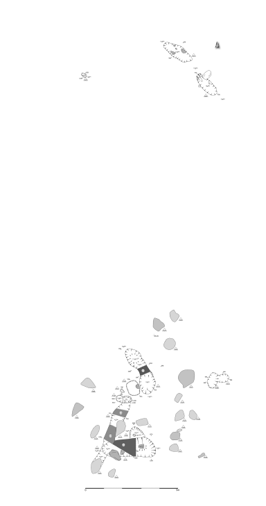
Area E29 was situated in between the Templepatrick Road and the Belfast Road to the south-west of the Ballynure roundabout. The site was situated on the north-eastern edge of a gently rolling hill which had been cut to the north and west to allow for the Templepatrick Road.
The site consisted of two small discrete areas 13m apart, the northern area contained two small oval pits, C1551 and C1555, and a post-hole, C1562. The southern area contained two early pits C1570 and C1571, which were then cut by several later features. As well as these interconnected features there were three pits, C1508, C1511 and C1526, and a possible post-hole, C1514.
This site did not contain any clear signs of long term occupation, however given the truncated nature of the remains due to the numerous modern agricultural features overlying the archaeological features it is probable that the majority of the archaeology which was present on this site was destroyed in the intervening years.
Even with this truncation there was clear evidence for use from the Neolithic through the Bronze Age and into the post-medieval period.
Two of the features contained artefacts which can be roughly assigned to the Neolithic and Bronze Age. The Neolithic pottery was from C1570/F1554, and the Bronze Age Pottery was from C1538/F1539. These two features were interconnected but with no other easily identifiable artefacts in any of the other features and no physical relationship between many of the features it is difficult to say which features are related to each other.
There were some similarities between three of the features, pits C1505, C1526 and C1547. All contained large sub-angular stones which filled the base of the cuts. These pits were roughly in a straight line across the middle of this area; C1501 cut an earlier pit, C1571, and pit C1547 cuts both of the features that contained the pottery, C1538 and C1570, which means that these pits post-dated the Bronze Age.
There may also have been a connection between the features which contained burnt bone, C1508, C1511 and C1540, however this can only be considered tenuous as there are many different processes throughout time which may produce burnt bone and as such the features may date to completely different time periods.
The specialist reports and radiocarbon dates will go far in helping us to understand the phases of the site and how the different features inter-relate.
Post-excavation work is in progress and the full report should be available by the end of August 2013.

Area E29, Overall Site Plan
