2012:035 - KILWAUGHTER QUARRY, Demesne of Kilwaughter, Antrim
County: Antrim
Site name: KILWAUGHTER QUARRY, Demesne of Kilwaughter
Sites and Monuments Record No.: N/A
Licence number: AE/12/108
Author: Johnny Barkley, Northern Archaeological Consultancy Ltd.
Author/Organisation Address: Farset Enterprise Park, 638 Springfield Road, Belfast, BT12 7DY
Site type: Habitation site
Period/Dating: Prehistoric (12700 BC-AD 400)
ITM: E 735353m, N 901270m
Latitude, Longitude (decimal degrees): 54.840977, -5.892706
Monitoring and excavations have been undertaken at Kilwaughter Quarry from 2007 under various licences. Phases 1, 2 and 3 took place in 2009, 2010 and 2011, directed by Gavin Donaghy, Christina O’Regan and Jonathan Barkley respectively (Excavations 2009, No. 47, AE/09/116, Excavations 2010, No. 39, AE/10/137 and Excavations 2011, No. 27, AE/11/078). This current phase of excavation (Phase 4) was undertaken in autumn 2012.
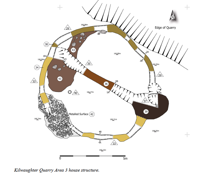
During topsoil stripping of the southern part of the site a charcoal-rich oval annular feature filled with burnt soil was uncovered (subsequently called Area 3). This feature was approximately 9m in diameter and the ring was up to 0.5m in width. To the west, disappearing into the non-stripped area to the west, was a large 3m+ diameter stone-packed feature and several other spreads, pits and linear features (subsequently called Area 2). To the north of the annular feature was a charcoal-rich spread, running approximately east to west (Area 1). This area was the continuation of an archaeological spread discovered and excavated by NAC in 2009. This feature was much more ephemeral than that portion of it uncovered in 2009 though it did cover an area of some 5m x 8m.
The features uncovered comprise what appeared to be the remains of a house (Area 3), from which several struck flints and pieces of coarse pottery were recovered from the topsoil during stripping. The feature to the west was revealed as two intercutting features with a stone-packed upper fill (Area 2). A series of pits, spreads and linear features lying between the spread and annular feature were also uncovered (Area 2). The spread to the north of the house (Area 1) was the western extension of a series of spreads and pits associated with a gulley uncovered during monitoring and excavation carried out by NAC in 2009 (AE/09/116) and contained evidence of a middle Neolithic occupation/industrial area.