2011:639 - HUMPHRYSTOWN, Wicklow
County: Wicklow
Site name: HUMPHRYSTOWN
Sites and Monuments Record No.: N/A
Licence number: 11E0204
Author: Chris Corlett, National Monuments Service
Author/Organisation Address: Dept of Arts, Heritage and the Gaeltacht, Custom House, Dublin 1
Site type: House - Neolithic
Period/Dating: Neolithic (4000BC-2501 BC)
ITM: E 696802m, N 707645m
Latitude, Longitude (decimal degrees): 53.110576, -6.554148
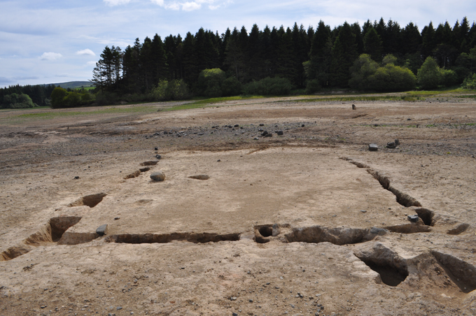
The site was first identified by local man Martin Byrne in April 2011, while walking the shoreline of the Poulaphuca Reservoir after a prolonged dry spell had resulted in a reduction of the water levels. The reservoir was created in 1940, and resulted in the flooding of some 5,000 acres of former agricultural land and bogland. The area where the Neolithic house was discovered (OD 184m) was formerly agricultural land on a gentle slope overlooking the King’s River. The shoreline is normally inundated by the water and only becomes exposed when the water levels drop after a prolonged dry spell. This new site at Humphrystown is only the second example of a Neolithic house found to date in County Wicklow. A Neolithic house in Baltyboys Upper was located some 500m to the north of the house described here, also on the shoreline of the reservoir (Excavations 2010, no. 834, 07E1127 ext.) This is a testimony to the unusual context that has led to the discovery of both Neolithic houses at the reservoir, combined with the richness of early prehistoric remains in this area.
To the east of the house are the remains of plough furrows (aligned west-north-west/east-south-east), but there is no trace of these across the house itself. It appears, therefore, that, apart from the removal of topsoil, erosion by the reservoir has also removed a significant amount of subsoil, and in the area of the house the subsoil has been removed to a level below the base of the plough furrows. This would suggest that the site has been severely truncated and it seems likely that only the lowest levels of the cut features survive at the site. This erosion appears to have resulted in the scattering of a number of artefacts that may have been directly associated with the house itself, or at least associated with activity contemporary with the habitation of the house. These objects included a flint hollow scraper, two flint scrapers and a Bann flake. A stone axe was a surface find 20m south of the house and is likely also to be related to the habitation of the house.
The rectangular house is defined by a slot-trench on three sides and measures c. 6.2m east-north-east/west-south-west x 4.3m across. The slot-trench is missing along the west. It was initially thought that this end of the house might have been eroded away. The western ends of the north and south long walls survived to a reasonable depth where they terminated, however, so it seems unlikely that the absence of the slot-trench here was a question of survival. It may, of course, mean that the building was unfinished or open at this end. Alternatively, perhaps the construction was different at this end of the building and did not require a foundation trench. If so, such a deliberate change in construction technique must surely have been deliberate and therefore must imply a specific reason.
There was a gap, 0.52m wide, midway along the slot-trench of the southern long wall, possibly representing an entrance. The fill of the slot-trench differed slightly to the east and west of this gap. On the western side the slot-trench was somewhat V-shaped (0.38m wide and 0.32m deep) and featured a significant quantity of charcoal (oak and hazel) in the fill (and thus was generally more similar to the fill of the slot-trench along the northern side). A sample of hazel charcoal (1.2g) was selected for AMS dating and returned a 2-sigma date of 3700–3630 and 3580–3530 cal. BC. There were no artefacts in this section of the ditch, although a small amount of cremated bone was found in the fill immediately west of the possible entrance gap. East of the possible entrance gap the slot-trench was wider (0.34–0.4m) and slightly deeper (0.36–0.38m), with a more distinctive U-shaped profile. The fill generally consisted of redeposited clay and contained less charcoal and a lot more burnt red clay. The burnt clay was redeposited and not the result of in situ burning. At the eastern end of the southern wall, near the meeting with the eastern end wall, some sherds of carinated bowl pottery were found in the fill, but there were no other finds along this section of the southern wall.
The slot-trench was uninterrupted along the north. It was generally narrow (0.14–0.25m wide and 0.2–0.35m deep). Apart from a small area near the mid-section of the wall, the fill contained a significant amount of charcoal (oak(?) and hazel) and burnt red clay. Two lithics and three sherds of carinated bowl pottery were also recovered. Cremated bone and two hazelnuts were found in the fill near the western terminal of the wall.
The slot-trench continued uninterrupted along the eastern end wall. Here the upper fill featured a lot of charcoal, whereas this was less of a feature in the lower layers. Several finds were recovered from the fill of the eastern end wall, including two lithics and several sherds of carinated bowl pottery. Three post-holes cut into the fill of the slot-trench: F13 (0.16m x 0.12m, 0.2m deep), F14 (0.14m x 0.1m, 0.12m deep) and F13 (0.3m across, 0.3m deep). Just outside the slot-trench, towards the northern end of the eastern wall, was a well-defined oval pit, which measured 0.32m x 0.49m across and 0.34m deep. The fill of this pit consisted of a dark brown soil, with significant amounts of charcoal as well as some cremated bone and six sherds of carinated bowl pottery. The charcoal was identified as consisting of alder, oak and hazel. A sample of hazel charcoal (3g) was selected for AMS dating and returned a 2-sigma date of 3650–3520 and 3390–3390 cal. BC.
Within the footprint of the house were two features. In the south-east corner there was a shallow, irregular pit, 0.28m x 0.4m across and 40mm deep. The fill consisted of a compact clay that represented redeposited subsoil but which contained some charcoal flecks. There was no in situ burning.
Just south of the centre of the structure was a small D-shaped pit, 0.28m x 0.4m across and 0.25m deep. Once again the fill largely consisted of redeposited subsoil and contained some charcoal (oak) and burnt clay, but there was no in situ burning. A single piece of carinated bowl pottery was present in the upper fill. A relatively large stone (0.3m x 0.2m x 0.12m) occupied the eastern half of the pit and may represent a packing stone. If so, the remaining part of the pit could only have accommodated a relatively small timber post, perhaps not much more than 0.1m across.
About 4m to the east-north-east of the house is a well-defined pit that measured 1.09m long, 0.76m wide and 0.17m deep. Its edges and sides were straight, indicating that it was carefully dug. It appeared to represent a trough feature, and it is worth noting that the marly subsoil here is capable of holding water without any need for a lining. The single fill consisted of grey-brown sticky clay that was sterile and did not even contain a pebble or a stone. There was no material present that allowed for dating of this feature.
The site produced an assemblage of 30 sherds of pottery; these have been examined by Helen Roche, who has estimated the presence of an estimated six Early Neolithic carinated bowls.
No. 639. Humphrystown: Neolithic house.