2011:621 - CASTLEQUARTER, Clohamon, Wexford
County: Wexford
Site name: CASTLEQUARTER, Clohamon
Sites and Monuments Record No.: N/A
Licence number: 09E0393
Author: James Lyttleton
Author/Organisation Address: Dept of Archaeology, University College Cork
Site type: Castle - unclassified
Period/Dating: Multi-period
ITM: E 693253m, N 654571m
Latitude, Longitude (decimal degrees): 52.634013, -6.621430
A third season of fieldwork was conducted close to the site of a castle and manor house (WX009-005/008) in the townland of Castlequarter, Clohamon. This work is an important component of an international research project sponsored by the Royal Irish Academy, Memorial University of Newfoundland, Historic St Mary’s City, Maryland, and University College Cork. The project is looking at the archaeology of early English colonial expansion in the 17th century across the North Atlantic, with particular reference to Sir George Calvert, 1st Lord Baltimore, whose family acquired lands in the plantations of north Wexford and Longford, as well as established colonies in Newfoundland and Maryland through the 1620s and 1630s. In the context of the early origins of empire, the plantations in Ireland were important, as they provided English officials, merchants and soldiers with the necessary experience in funding, transporting and settling colonists further afield in North America.
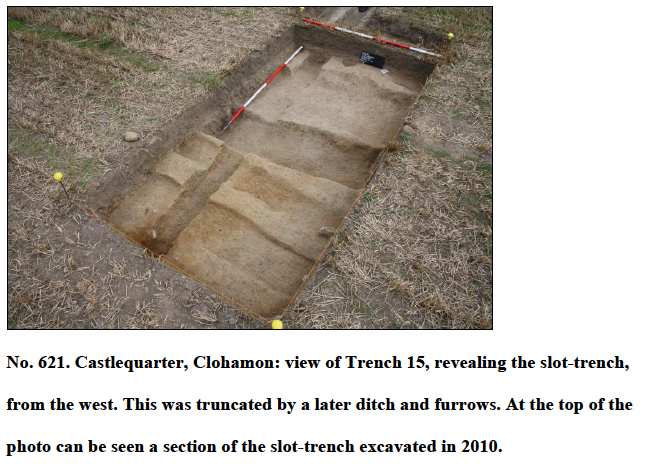
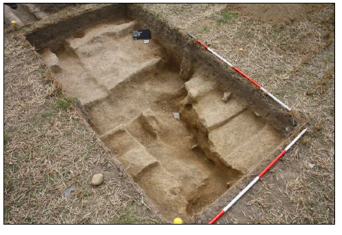
In the field to the north of the castle site, geophysical survey (magnetic gradiometry) in the 2009 season indicated a series of anomalies, including a couple of linear boundaries that were marked on the first-edition OS map. Test-pitting and sieving of the ploughsoil in the same area recovered ceramics and tobacco pipe fragments that were typical of the 17th century. In the same area in 2010, Trench 15 revealed a slot-trench for a sill beam. The single fill of this feature yielded a copper farthing token that was issued under royal licence sometime between 1625 and 1644. It was thought that the slot-trench uncovered might have represented a rare survival of a timber-framed building. In the 2011 season it was decided to extend Trench 15 by another 4m to the north-west to further expose this slot-trench in the hope that it would define a corner of a building, as well as expose other occupational features. The slot-trench continued to run north-west/south-east. No evidence for stone packing was found within it, nor any evidence for the insertion of planks or post-holes at its base. There was no evidence for occupation activity either. It is not clear what function this slot-trench would have fulfilled, but on balance it was probably associated with a fence line. The slot-trench was subsequently truncated by later agricultural activities, represented by furrows and a ditch. It, in turn,truncated an earlier ditch that curved slightly from north to south, a direction completely at variance with the surrounding post-medieval archaeology and landscape.
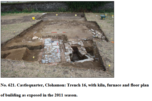
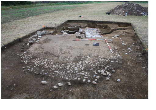
Also in the 2010 season, the remains of a brick structure with an attached furnace were uncovered in a 3m by 3m cutting, Trench 16. The brick structure, as then exposed, measured 2.25m by 1.23m externally. The brick wall, bonded with a lime-based mortar, survived to two courses in height. The interior was covered with shale flagstones heavily bonded with a lime-based mortar. Attached to the north-east exterior of the brick structure were the remains of a furnace, placed into a stone-lined pit and accessed via a flight of stone steps. It was initially thought that this structure probably served as a bakehouse/brewhouse for the occupants of the manor house and/or village. Many household inventories of the period record the presence of ancillary buildings such as these, and a lease of Clohamon dated 1660 indicates that there were indeed a number of outbuildings associated with the manor house.
Trench 16 was expanded in the 2011 season, revealing more of the building. The brick-walled structure was revealed to be the basal remains of a rectilinear kiln, measuring 3m by 1m internally. The floor of the kiln was rather rough in construction, with shale flagstones bonded with mortar. Below this floor was an insulation of highly compact clay, designed to keep heat from dissipating too quickly and to reduce rising damp. Below this clay layer were deposits of mortar and brick, which covered a basal floor foundation of shale flagstones. The furnace that heated this kiln was fully excavated, revealing a hearth with tapered sides lined with concave granite stones. The splayed opening of the hearth was built with roughly coursed shale flagstones and some brick bonded with mortar. At the base of the hearth’s back wall were two courses of brick. The sides of the hearth were lined with clinker, resulting from the burning of coal. It appears that the hearth and kiln projected from the rear of a timber-framed building. Lack of wall foundations along the sides of the building suggests that sill beams sitting high on the ground were used as supports for a timber-framed structure. The basic dimensions of one sill beam were still evident on the ground surface, where ditch features respected the south-western side of the building. There were two phases of flooring: a cobble floor surviving to 4m north-west/south-east by 4.6m in extent, which was subsequently covered over with a mortar floor. There were some deposits to indicate that the cobble floor saw some usage before it was covered over.
Running along the south-western side of the building were two intercutting ditches; the earlier ditch was filled by cobble and sand, which produced a tobacco pipe stem of 17th-century date, and was later cut by another ditch at an angle that mirrored the line of the building. This shallower ditch was filled by cobbles, large shale pieces and sandy silt. The earlier ditch also cut into a deep linear deposit of gravel, sand and cobbles which happened to follow the line of a north-east/south-west-running lane recorded on the first-edition OS, linking Clohamon Castle with the village. All the features and structures uncovered during the 2010 and 2011 seasons, including the timber-framed building, were positioned at right angles to this laneway.
The topsoil covering the timber-framed building yielded ceramics, glass, metal and tobacco pipe fragments spanning the 17th to 19th centuries, but the fill of the foundations of the kiln and hearth produced a pipe stem fragment and the base of a vessel of North Devon Gravel-Free Ware type that suggested a mid-17th-century date for construction. The final fill of the hearth contained a handle, possibly of a Spanish olive jar, along with a number of tobacco pipe stems of the mid- to late 17th century. This would suggest a construction date for the building sometime in the middle decades of the 17th century, followed by active use up until the end of the same century. Surviving estate papers relating to Clohamon indicate that Cecil Calvert, the founder of the Maryland colony, was actively managing his Irish estate between the 1630s and 1660s, with land being leased and rented to English and Irish tenants, fields being laid out, and the extensive oak woodlands in the locality being exploited to supply the demand for charcoal, pipe staves and lumber.
In consultation with Dr Colin Rynne of the Dept of Archaeology, UCC, this timber-framed building is currently being interpreted as a malt-house, where harvested barley grain would have been processed into malt. In a period which saw the increased consumption of beer, over the previously more popular wines and spirits, the development of a malt-house was essential for the occupants of Clohamon. The malt-house uncovered this season is a unique survival of such a building, as low-status buildings, whether in the grounds of manor houses or elsewhere, rarely survive. The archaeological fieldwork to date has yielded a valuable insight into the industrial and architectural development of Clohamon under the stewardship of the Lords Baltimore.