2011:199 - MEETING HOUSE SQUARE, Dublin
County: Dublin
Site name: MEETING HOUSE SQUARE
Sites and Monuments Record No.: DU018-020804, -020345, -020239, -020510
Licence number: 11E0058
Author: Alan Hayden, Archaeological Projects Ltd.
Author/Organisation Address: 82 Melvin Road, Terenure, Dublin 6W
Site type: Habitation site, Riverine revetment, Watercourse, Road - road/trackway and Cultivation ridges
Period/Dating: Multi-period
ITM: E 715531m, N 734110m
Latitude, Longitude (decimal degrees): 53.344586, -6.264951
Excavations were undertaken from 28 February to 1 June 2011 in advance of the development of most of the square. The site originally straddled the edge of the River Liffey, the bank of which in this area was delimited by a 3–3.5m-high bedrock cliff.
Phase 1
The earliest evidence of human occupation, dating probably from the 11th or 12th century, was uncovered on the then dry ground on top of the cliff and lay between 1.4m and 1.8m OD. A large number of post-holes, gullies, stake-holes, a hearth and cart ruts were revealed and represented the remains of at least one Type 1 Hiberno-Norman house and several levels of superimposed structures. Owing to later river erosion only the base of the features survived.
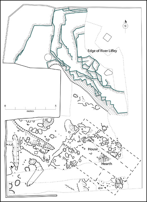
No. 199. Meeting House Square, Dublin: plan of Phase 1 features.
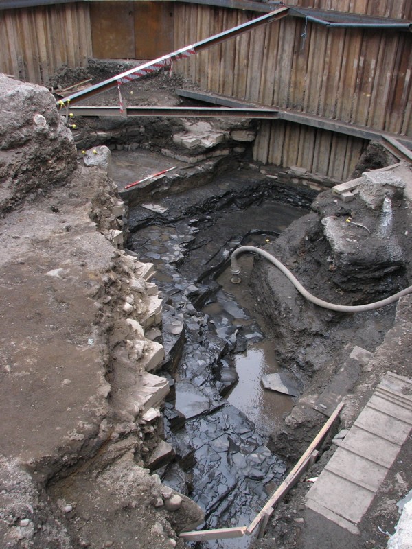
No. 199. Meeting House Square, Dublin: 12th-century edge of River Liffey.
De Courcy (1996) has suggested that high-tide level in the Liffey has consistently lain at approximately 2m OD (Malin)—4.7m OD (Poolbeg)—since the Viking period. His data for the period from the 13th century onwards are drawn from a number of sites excavated in the town to date. There is, however, less evidence for tide levels before the 13th century. The early structures uncovered at Meeting House Square lie below his postulated high-tide level but were clearly erected on dry land. The fact that there are several levels of activity represented indicates that the structures stood here for a considerable period and hence were not just erected between one spring high tide and the next. They therefore clearly suggest that the water level in the river was lower before the 13th century. The pre-Norman buildings and the continuance of the property boundaries between Phases 1 and 2 suggest that this area may have been intensely settled and for a considerable period before the Norman invasion. It is the earliest and most definite evidence yet uncovered for a substantial extramural suburb outside this side of the town.
Phase 2
At the beginning of the 13th century the river inundated the site and the earlier buildings were destroyed. Attempts were made to reclaim the area. A series of terraces, defined by post-and-wattle fences and ships’ planks and filled with organic material, were constructed on the site. Other boat parts were also uncovered, including a number of oak treenails, pieces of rope and fabric; some of the latter could have been caulking. A number of lead line-fishing weights and a fish-hook were also uncovered, showing that fishermen used the area. A good assemblage of pottery was recovered from the deposits of this phase. The range of forms present closely resembles that uncovered around the 1210 revetments at Wood Quay (McCutcheon 2006). It suggests that reclamation was being undertaken along a considerable stretch of the southern bank of the Liffey at the same time, possibly in response to a major rise in the level of the river. The changes in the level of the Liffey may be a result of the movement southwards of the circumpolar vortex, which occurred around AD 1200. This caused the expansion of the polar ice-cap and would have resulted in colder and stormier weather (Lamb 1972–7, vol. 2, 440–60).
Phases 3 and 4
The early 13th-century reclamation proved unsuccessful and the higher ground on the site continued to be inundated by the river. The fences and structures erected were partly washed away and covered by a succession of layers of sand and fine gravel that built up until the 16th century. Occupation of the higher land further south of the site evidently continued, however, as a long narrow drain was dug diagonally across the site into the river deposits. Some human deposited material was uncovered from these river deposits. While only a very small number of highly abraded sherds of pottery were found in these layers, they occurred consistently throughout them. Many fragments of ceramic line-impressed and two-colour floor tiles were also found. These included unused tiles and wasters. Sherds of ceramic cockscomb ridge tiles, pieces of worked Dundry stone and lumps of plaster were also retrieved from these deposits and are suggestive of waste from a construction site, probably from one of the many ecclesiastical sites in the area.
The remains of part of the western side of a watercourse extending down the eastern side of the site were also uncovered. Owing to the disturbance caused by excavation for the basement east of the site in 1996, however, it is not possible to determine exactly when this watercourse was laid out. The watercourse ran down to the north-eastern corner of the site, where the remains of the western ends of three substantial reused 14th-century timbers survived. Unfortunately the fragments uncovered were only the very western ends of what originally were substantial timbers, the majority of which had been removed by the excavation of the trench for the basement. A short unpublished report on the watching brief maintained on the excavation of the basement survives and it records the finding of many large reused timbers. These may have been part of a mill or dock. Further parts of this watercourse were previously uncovered south of the site in trenches excavated by Martin Reid (Excavations 1993, no. 76, 93E0194) and Antoine Giacometti, Arch-Tech Ltd (Excavations 2007, no. 471, 07E0582). Speed’s map of Dublin (1610) shows a small east–west-aligned inlet off the Poddle immediately behind the houses at the western end of Dame Street. This could be the start of the watercourse, which would have taken water from the Poddle (possibly via one of the dams that are mentioned in the area in the medieval period) and led it in a loop down to the Meeting House Square site and then back to the Liffey. The watercourse on the Meeting House Square site was filled with thick deposits of organic silt, which contained a good range of organic finds. It is not clear when it went out of use. The limited areas of the uppermost surviving fills contained medieval pottery, which is not closely datable to more than the 14th–16th centuries. After the wooden structure had gone out of use, the river deposited layers of sand and gravel over it. Several superimposed and narrow unlined natural water channels, running south-east/north-west, survived in these layers in the northern third of the site. They were successively filled up and recut into the river-deposited layers until they too finally disappeared. At the end of this period of inundation, the whole area of the site was roughly flat but sloped downwards slightly to the north.
Phases 5 and 6
The building of a river wall shown on Speed’s map along the edge of the Liffey north of the site in the 16th century finally reclaimed the site and from then on it was dry land. At the westernmost side of the site the remains of a north–south-aligned roadway were uncovered, laid down directly on top of the river-deposited layers. It consisted of a dump of gravel with a compacted and roughly metalled upper surface. There was a lateral drain on its eastern side. This roadway is shown on the 1673 map of Dublin, where it is labelled ‘Pooley’s Alley’. It is, however, probably of late 16th- or early 17th-century origin. Thick deposits of cultivated soil overlay the rest of the site. This soft green clay is typical of areas under cultivation and has been noted before on many occasions on sites excavated in and around the medieval town. At Meeting House Square it could not have developed from the very hard river-deposited sand and gravel. It also contained an odd assemblage of pottery, ranging in date from the later 12th to the early 17th century, and so it appears to have been introduced from elsewhere in order to allow the site to be used for cultivation. By the end of the 17th century the cultivation had buried the surface of Pooley’s Alley. The alley also disappears off maps by the end of the 17th century and the area was described as waste ground in 1709.
Phase 7
The final phases of activity evidenced on the site consisted of 18th- and 19th-century wall foundations and cellars, and the remains of a substantial well lined with two wooden barrels and containing a very well-preserved pump stick.
References
De Courcy, J.W. 1996 The Liffey in Dublin. Dublin.
Lamb, H.H. 1972–7 Climate: present, past and future (2 vols). London.
McCutcheon, C. 2006 Medieval pottery from Wood Quay, Dublin. National Museum of Ireland Medieval Dublin Excavations 1962–81, Series B, Vol. 7. Dublin.