2011:157 - CARRYDUFF: Mealough Road, Down
County: Down
Site name: CARRYDUFF: Mealough Road
Sites and Monuments Record No.: N/A
Licence number: AE/11/009
Author: Colin Dunlop, Northern Archaeological Consultancy Ltd.
Author/Organisation Address: Farset Enterprise Park, 638 Springfield Road, Belfast BT12 7DY
Site type: House - Neolithic, Ring-ditch, Structure, Pit and Ringfort - rath
Period/Dating: Multi-period
ITM: E 734784m, N 865778m
Latitude, Longitude (decimal degrees): 54.522452, -5.917938
The archaeology uncovered on the site has been preliminarily identified as Neolithic in Areas A and B, Bronze Age in Area C, Early Christian in Area F, and medieval–post-medieval in Areas D and G. Only Area E is currently undated. All but one of these areas occupied hilltop locations; the exception was Area G, which was right at the bottom of the hill, close to the river.
Currently no specialist flint or pottery reports (except for the post-medieval pottery, which could be analysed in-house) or radiocarbon dates have been obtained, as post-excavation work is ongoing.
Areas A and B: Neolithic house and landscape
Areas A and B were located 19m apart on the top of a small hill on the south-eastern edge of the site. Pottery found within pit C32, Area A, and pit C134, Area B, appears to be Neolithic in date, which suggests a link between these two features and possibly between the two areas.
Area A, from north to south, consisted of a possible Neolithic structure, a fence line or partition and a possible working area. Although the posts for the structure did not contain any artefacts, pit C32, just to the north of the structure, contained pieces of pottery which appear to be Neolithic. The partition did not contain any artefacts. Finally, the working area did contain sherds of pottery from the gully C82 and an anvil stone from pit C16, but none of these artefacts could be identified as definitely Neolithic.
The post-holes in the northern half of Area A, C5, C28, C26, C30, C20, C92 and C65, appear to be the posts for a Neolithic house with an internal hearth, C95.
The structure at Mealough Road was towards the smaller end of the size range for early Neolithic structures in Ireland; it measured 6.85m by 6.4–7.1m, aligned north-west to south-east, with an internal floor space of only 43.84–48.64m2 (Grogan 1996, 52).
The orientation of early Neolithic rectangular houses across Ireland and Europe largely falls within a south-west to north-east and north-west to south-east arc (Topping 1996, 161). This means that one of the long walls of the structure faces south, giving maximum solar heat absorption, and the house at Mealough Road fits this pattern.
In general, early Neolithic (4000–3500 BC) houses were rectangular. Early Neolithic houses in Ireland tend to be built with split oak timbers placed vertically next to one another in a foundation trench; corner posts and internal divisions are a regular structural feature. The second type of structure is post-built with what are presumed to be wattle walls rather than split planks, such as the one at Lough Gur A (Ó Ríordáin 1954) and Strawberry Hill, Co. Down (Nicol, unpublished a); these post-built structures are much less common and it is interesting that the house discovered here at Mealough Road is of this latter type. In the middle and later Neolithic (3500–2500 BC) houses tended towards circularity.
Area A also contained a fence line or partition 3m to the south of the southern wall of the house. The partition consisted of five posts, C7, C3, C86, C80 and C67, aligned roughly north-east to south-west. There is no stratigraphic link between the partition, the possible Neolithic structure or the possible working area. If both the working area and the structure are dated to the Neolithic, it would be unlikely that these post-holes date from another period. If, however, the two areas on either side are dated to separate periods it would be impossible to link these post-holes with either one.
It is assumed that these post-holes represent a screen to block the view of the working area from the possible Neolithic house. Similar structures have been found at several sites, including Thornhill, Co. Londonderry (Logue 2003), Ballyharry House 1, Co. Antrim (Moore 2003), and Coolfore, Co. Louth (Ó Drisceoil 2003). It is possible that these partitions had more than one function, not only screening the house from the working area but also serving as a physical representation of the ability to alter and control the environment. This element of control has been identified at ritual sites, with the use of man-made and natural formations to control the view and the passage of people through the landscape.
The last features in Area A were 2m south of the partition and consisted of a curving ditch, C82, partially surrounding a series of pits and post-holes, C10, C22, C89, C18, C16 and C59. At the eastern end of the gully were a series of four post-holes, C61, C63, C88 and C91.
Physical evidence for the date of this area is sparse; there are a few pieces of pottery from gully C82 and there was an anvil stone from pit C16. The sherds of pottery were small and fragmented, with no diagnostic pieces; to a non-specialist they could appear either Neolithic, Bronze Age or Early Christian. The anvil stone would suggest a period when the production of flint artefacts was common, but this could be either the Neolithic or the Bronze Age.
The gully surrounding the area, C82, could have been a windbreak to shield those working inside from the elements. This screen could also have served to protect the structure to the north from any hot embers that may have arisen from the working area. Evidence of the use of fires was identified in the large amount of charcoal recorded in pits C16 and C18, although it was not clear whether the burning had taken place in situ.
The description of the area as a working area is due to the size of the pits and the lack of any clear structure; it was unusual, however, as although an anvil stone was recovered there were very few flint or pottery artefacts. The lack of artefacts is not necessarily a problem, as there are plenty of processes, e.g. tanning and meat-smoking, which would not have left any material remains.
It could be, however, that some or all of the features in this southern area are from a separate period. Perhaps we are looking at an Early Christian structure rather than a Neolithic working area. There were no post- or stake-holes in the bottom of the gully to indicate support for a windbreak, which could mean that it was a drip trench. An example of an Early Christian structure consisting only of a drip trench was found at Terryhoogan, Co. Antrim (McSparron 2004), and another at Knockmore, Co. Down (Nicol, unpublished b). The shape of the gully would be consistent with a subsquare structure, although only two sides remain visible. This structure could have been a maximum of 7.5m long by a minimum of 4.2m wide, although this is a rough estimate, given that only two sides survived. It is assumed that these buildings had turf walls, with the upright posts either embedded into the wall or possibly sitting on stone pads. The four posts at the end of the gully could be part of a porch in front of a doorway.
At least one of the pits inside the gully could have been a hearth for the house; the other features may have been for the house or they could be part of the Neolithic landscape.
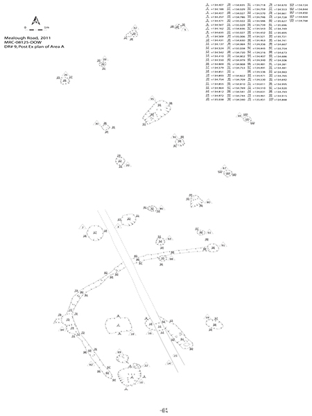
No. 157. Mealough Road, Carryduff: post-excavation plan of Area A, Neolithic house.
Area B was 19m to the east of Area A. On the western side it consisted of a series of pits (C114, C121, C123 and C125) and two post-holes (C112 and C116). On the eastern side there were two near-circular gullies (C119 and C141) and a partial gully (C139); these surrounded two post-holes (C137 and C143) and a large central pit (C134).
The eastern features contained no artefacts and therefore they currently cannot be dated. The large pit was too big to be a hearth, and as only two post-holes were present these features do not appear to be part of a structure. It was therefore impossible to ascertain their function.
The eastern half of the area contained a large pit (C134) with substantial deposits of flint and pottery that could be dated to the Neolithic. To the east of this pit there were two post-holes and two near-circular gullies that appeared to surround it. Pottery was recovered from both of the gullies but the pieces were small and undiagnostic.
While it is likely that two features that appear to respect one another are in some way connected, this is not always the case. Although the gullies in the eastern part of Area B appear to be associated with the large central pit, it is possible that they represent the drip trench for a figure-of-eight house similar to (but smaller than) the ones uncovered at Deer Park Farms, Co. Antrim (Lynn 1988), which would then date the feature to the Early Christian period.
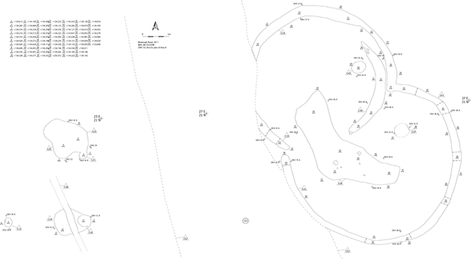
No. 157. Mealough Road, Carryduff: post-excavation plan of Area B, Neolithic ditches.
Area C: Bronze Age ring-ditch
The ring-ditch uncovered at Mealough Road (C40, C42) contained one definite entrance to the north-east and a second possible entrance opposite the first to the south-west. Inside the ditches was a large, misshapen pit (C38) in the centre, with a post-hole (C48) to the north-east and a pit (C49) to the south of centre. The northernmost ditch, C40, was associated with a large, shallow pit, C46, and cut another large pit, C51; finally, there was a pit, C36, outside the ring-ditch to the north. Ring-ditches are common Bronze Age features that have occasionally been identified in both the Late Neolithic and the Early Iron Age.
Ring-ditches are burial monuments usually associated with cremations, either in a pit in the centre, in a mound in the centre (if one survives) or in the ditch. No burnt bone was recovered from the fills of either ditch and there was no central or satellite cremation. A large, irregular pit was excavated at the centre of the feature, but this did not appear to be archaeological and was more likely to be tree disturbance. If this was the case the tree did not fall over, as the tree roots usually leave a diagnostic half-moon pit feature. Next to this irregular pit was a post-hole, although it was unclear what function it might have served.
The entrance in the north-eastern half of the ring-ditch was very clear; the opposite entrance, however, was a little more obscure and may be a result of site erosion. If we assume that only the north-eastern entrance was part of the original feature, the ring-ditch would be similar to one excavated at Tullymore, Co. Donegall (Waddell 2000); if, however, we assume that both entrances were original features, it would be similar to a barrow at Coumgagh, Co. Kerry (ibid.), although both of these were much larger than the one discovered near Mealough Road.
The northern ditch, C42, cut an earlier pit, C51, which contained a large amount of pottery and flint that appeared to date from the Bronze Age. Given the size of the pieces of pottery deposited in the pit and the lack of abrasion on their broken edges it is unlikely that this was a rubbish pit; the pieces of pottery were deliberately placed into the pit, indicating a ritual aspect. Clearly the ring-ditch was dug after the deposition of this pottery. It could also be that the ring-ditch was built some time after the pit and might be Iron Age. This would be similar to a site at Strawberry Hill, Lisburn (Nicol, unpublished a), where an Iron Age ring-ditch cut a Bronze Age pit on the top of a small hill.
The assumption that this is a ring-barrow may be premature; it could also be a very simple structure similar to Hut 3 at Curraghatoor, Co. Tipperary (ibid.).
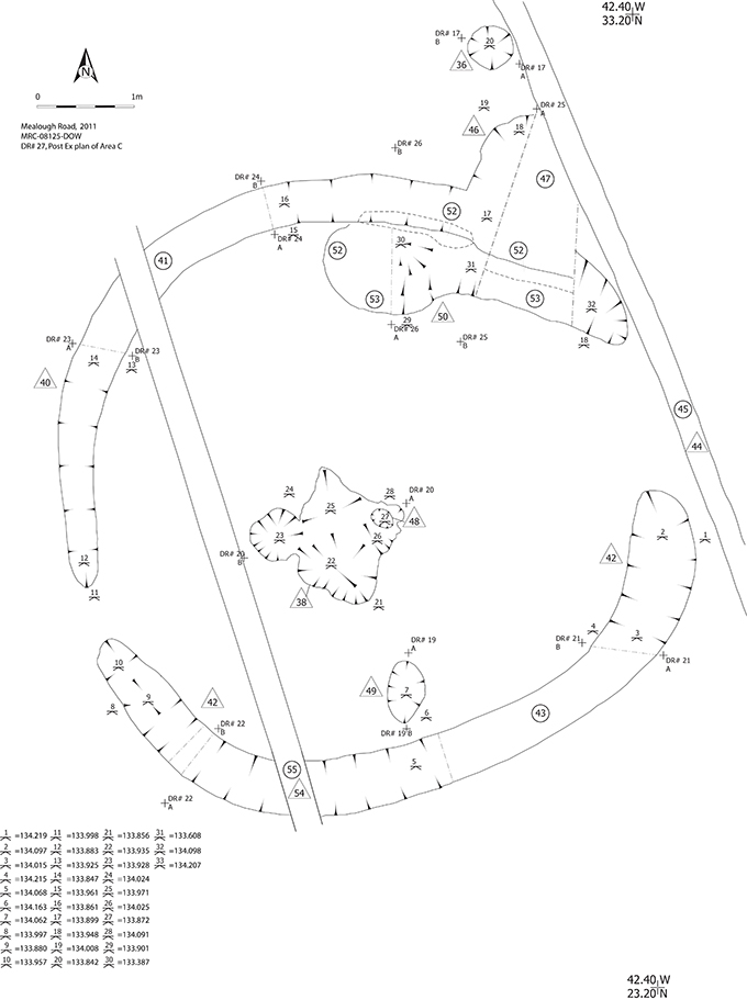
No. 157. Mealough Road, Carryduff: post-excavation plan of Area C, Bronze Age ring-ditch.
Area D: post-medieval structure and undated pits
Area D contained the remains of a 19th-century structure in the form of two walls, S74 and S75, which made up the north-western corner of the building, and a cobbled floor, S76. With no artefactual material, the function of the building can only be guessed at from the excavated material and the map evidence. As it appears on the 2nd-edition OS map as part of a cluster of buildings, it can be presumed that the excavated remains once formed part of an isolated farm. The cobbled floor and the presence of what appears to be a drain suggest that the building might have been some form of barn or byre, or possibly even a dairy or other workroom. Although unable to state precisely the function of the building, it is possible to say that it was not part of the farmhouse.
The walls and floor uncovered in Area D were all that remained of a 19th-century farmhouse. A single dwelling or farm building was noted on the 1st-edition OS map, but its orientation makes it unlikely to be this building. By the time of the 2nd-edition OS map the single structure had disappeared and three buildings had taken its place. These were now orientated in a similar fashion to the remains excavated on site. Of the three buildings present the remains could be narrowed down to two of the buildings. Given the position of the walls and the location of the floor, the remains must have belonged to one of the northernmost buildings of the three, being the north-west corner. As a matter of conjecture, and based solely on the shape and size of the buildings on the 2nd-edition OS map, it is probable that the excavated remains formed the north-west corner of the western building. This presumes that the larger building would have been the farmhouse and that, given the location of the remains, the building in question was located closer to the existing field boundary.
Area E: undated pits
The pits in Area E, C300–C305, were laid out in a curving arch 11.1m long on the top of the northern hill opposite the hilltop which contained Areas A–D. These pits were not post-holes and therefore did not represent the wall of a structure, although it is likely that they continue to the east into an area which has yet to be investigated. One pit, C300, contained three pieces of flint, one of which was a possible core. Although artefacts were recovered, they were not diagnostic pieces and therefore the area remains undated. The function of these pits is as yet unknown.
Area F: Early Christian rath
Prior to monitored test-trenching, this rath was unknown. It presented no surface profile, it was not recorded on the OS maps and it did not appear on any aerial photograph of the area. Its location was perfectly suited to Early Christian habitation, however, as it sat on the apex of a small hill, with good views in all directions over the gently rolling landscape to the west of Carryduff, Co. Down. Excavation of the site has demonstrated that this was a univallate enclosure with an entrance to the south-east and an annexe to the north-east. Univallate or single-ditched enclosures are the most common type of rath surviving on this island and represent the defended dwellings of the lower end of the lordly classes during the Early Christian period. Such sites would have been surrounded by a ditch and an internal bank. While no traces of the bank survived, what may be described as a gentle ‘dishing’ or lowering of the enclosed area was noted. It is thought that this was the result of foot traffic over an extended period in this confined space, which naturally lowered the ground surface. With an internal diameter of c. 35m, this example is around the average size for this type of site (Edwards 1990).
Numerous excavations of raths have shown that many possessed a central house within the enclosure. The structural evidence recovered at Carryduff may be rationalised into forming such a structure. While the putative drip trench (C186) and the two large post-holes (C195 and C203), interpreted as forming the supports for the door jambs, appear to be strong evidence for the presence of a structure, the other evidence is less easy to interpret as structural. Taken together, however, the evidence does appear to suggest that the rath contained a single, circular house with a diameter in the range of 4.5–5m. The absence of large structural post-holes is relatively common, not from truncation of the site but because wicker or post-and-wattle buildings could be constructed without the need for large timbers.
The subrectangular annexe to the north-eastern side of the rath was also defined by a ditch and, presumably, an internal bank. Stratigraphically, this could be shown to post-date some of the filling of the rath ditch, but how late this enclosure was constructed is currently unknown. As no internal features were recovered, it is difficult to suggest what form of activity could have taken place here. It may only be suggested that it functioned as a small stock enclosure or as an enclosed vegetable garden. A field boundary ditch cut the fills of the annexe ditch and was thus even later again, though by how much is difficult to say.
The recovered artefacts were exceedingly few, but sufficient to give an impression of the activities going on at the site. The drip trench (C168) produced a single sherd of coarse pottery that suggests not only domestic activity but also the production of ceramic vessels. One of the door jamb post-holes (C195) produced fragments of metallic slag that, although small in volume, suggests that some form of metal-working was being undertaken here. Finally, the flint scraper from fill F187 in the rath ditch (C183) may be a residual item from the prehistoric period that was accidentally incorporated into Early Christian material. Alternatively, given its crudity, the piece may represent a contemporary attempt at flint-knapping. Unfortunately, none of these artefacts is closely datable.
While this rath excavation has not produced large numbers of high-status artefacts or evidence for long-term occupation, it is still of value. It provides an insight into the lives of a relatively small-scale farming and cattle-raising family of the lower lordly classes in the earlier part of the Early Christian period in County Down.
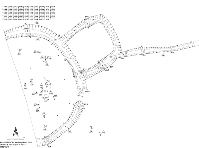
No. 157. Mealough Road, Carryduff: post-excavation plan of Area F, rath.
Area G: isolated pit
Although the pit in Area G, C146, was isolated, there is a possibility that it was associated with early post-medieval activity on the site. The single piece of pottery found within it was a piece of Transitional Ware dating from between the 15th and 17th centuries. This feature pre-dates the structure from Area D and has no parallels on the rest of the site. Its function is unclear.
References
Edwards, N. 1990 The archaeology of early medieval Ireland. London.
Grogan, E. 1996 Neolithic houses in Ireland. In T. Darvill and J. Thomas (eds), Neolithic houses in northwest Europe and beyond, 41–60. Oxford.
Logue, P. 2003 Excavations at Thornhill, Co. Londonderry. In T. Armit, E. Murphy, E. Nelis and D. Simpson (eds), Neolithic settlement in Ireland and western Britain, 149–55. Oxford.
Lynn, C.J. 1988 Ulster’s oldest wooden houses: Deer Park Farms, Glenarm, Co. Antrim. In A. Hamlin and C.J. Lynn (eds), Pieces of the past: archaeological excavations by the Department of the Environment for Northern Ireland 1970–1986, 44–7. Belfast.
Moore, D.G. 2003 Neolithic houses in Ballyharry townland, Islandmagee, Co. Antrim. In T. Armit, E. Murphy, E. Nelis and D. Simpson (eds), Neolithic settlement in Ireland and western Britain, 157–63.. Oxford.
Nicol, S. (unpublished a) Dobbies Garden Centre, Strawberry Hill, Lisburn, Co. Down. Unpublished report for Northern Archaeological Consultancy.
Nicol, S. (unpublished b) Coca Cola Bottling Plant, Knockmore, Lisburn, County Down. Unpublished report for Northern Archaeological Consultancy.
Ó Drisceoil, C. 2003 Archaeological excavation of a Neolithic settlement at Coolfore, Co. Louth. In T. Armit, E. Murphy, E. Nelis and D. Simpson (eds), Neolithic settlement in Ireland and western Britain, 176–81.. Oxford.
Topping, P. 1996 Neolithic houses in Ireland. In T. Darvill and J. Thomas (eds), Neolithic houses in northwest Europe and beyond, 157–70. Oxford.
Waddell, J. 2000 The prehistoric archaeology of Ireland. Dublin.