2011:156 - CARNMEEN AND LISDUFF, Down
County: Down
Site name: CARNMEEN AND LISDUFF
Sites and Monuments Record No.: DOW046-026
Licence number: AE/11/114
Author: Fintan Walsh, Irish Archaeological Consultancy Ltd.
Author/Organisation Address: 120b Greenpark Road, Bray, Co. Wicklow
Site type: Habitation site and Ringfort - rath
Period/Dating: Multi-period
ITM: E 707928m, N 830106m
Latitude, Longitude (decimal degrees): 54.208485, -6.345502
Large-scale open-area excavations were undertaken at Carnmeen and Lisduff townlands in advance of the proposed extension to Carnbane Industrial Estate, Newry. The excavations were undertaken from mid-October to Christmas 2011 with a team of up to 60 archaeologists. These excavations followed on from two phases of archaeological investigation (Phase 1 and Phase 2 evaluations) that were carried out at the site in 2009 by Warren Bailie and in 2010 by Warren Bailie and Vincent McClorey, Archaeological Development Services Ltd (ADS Ltd) (Excavations 2009, no. 238, AE/09/136; Excavations 2010, no. 238, AE/10/34). These investigations identified numerous archaeological deposits and features across the site, which measured c. 600m west-south-west/east-north-east by 600m. In addition, a possible circular enclosure was identified which may be the previously unlocated aerial photograph (rath) site DOW046-026. Further excavations were carried out by ADS Ltd under licence AE/11/59 from May to August 2011 ( Excavations 2011, No. 155). A total of 48 areas (grids) were topsoil-stripped (and subsequently expanded where necessary), targeting the archaeological deposits previously identified. Grids 16 (burnt mound complex), 21–22/24–26 (burnt mound complex), 28 (burnt mound) and 46 (Bronze Age landscape consisting of multiple ring-ditches and cremations) were fully resolved by ADS at this time.
The remaining grids (below) were resolved by IAC under licence AE/11/114.
Grids 1–15
A small number of dispersed archaeological features were identified throughout these grids, which were located in the north-east of the site on a high ridge with a westerly-facing aspect. Of note was a truncated burnt mound deposit measuring 3.5m by 2.5m by 0.2m deep, and a possible ‘four-poster’ structure measuring c. 3m x 2m. The post-holes ranged in depth from 0.07m to 0.17m. The remaining features in these grids comprised isolated pits, field boundaries and stone drains.
Grids 17–18
These grids contained a series of isolated pits, the largest being 1.1m in diameter and 0.3m in depth, all of which contained small quantities of charcoal but no finds. Central to the eastern half of these grids was a curvilinear feature (C107), which curved to the north-west and was approximately 30m in length, 0.5m wide and 0.05m in depth. It was very shallow and had silted up naturally with a sterile fill. The most prominent feature in this area was a deep linear gully, 6m long, 0.6m wide and 0.2m deep, which contained a charcoal-rich fill and frequent burnt bone fragments.
Grids 19 and 20
The main archaeology here comprised two large pits, one of which (C55) contained Neolithic pottery and burnt bone, which were surrounded by a series of post-holes, pits and stake-holes. Pit C55 was 1.24m in diameter and 0.25m deep. Four fills were identified, all of which were deliberately deposited material. Each of the fills contained large quantities of early Neolithic pottery and relatively small quantities of burnt bone.
Grids 23 and 27
Grid 23 contained two small, shallow pits with charcoal-rich fills. Two larger charcoal-rich pits were excavated in this grid by ADS under licence AE/10/34 (Excavations 2010, no. 238, AE/10/34). Nothing else of archaeological significance was identified in Grid 27.
Grids 29–33 and 34
An array of dispersed archaeological pits, post-holes and gullies were identified throughout this area, which measured c. 180m south-south-east/north-north-west by 70m south-west/north-east. Central to this area, however, was a curvilinear ditch, c. 40m long, 1.2m wide and up to 0.8m deep, with well-defined terminals at its southern and eastern ends. Seven small, shallow pits were positioned to the east of and within the projected enclosed space of this ditch. None of these features were of archaeological note, nor did the fills of the ditch contain charcoal-rich deposits or any artefacts.
A small structure defined by a series of stake-holes, post-holes and a gully was positioned c. 10m to the west of the curvilinear ditch. This measured c. 3m by 2.5m. Further groups of stake- and post-holes were recorded to the south-east of the curvilinear ditch though these were not well defined.
A more densely concentrated group of archaeological features recorded at the southern part of the excavation area included a distinct cluster of pits, post- and stake-holes within an area measuring c. 12m north–south by 10m. Central to this was a large cremation pit, 1m in diameter and 0.5m deep. This contained charcoal-rich fills with decorated pottery (probably Bronze Age), burnt flint and 30g of burnt bone. Within the most northerly portion of the site there were numerous isolated pits, linear drains and furrows of little archaeological significance.
Grid 34 did not contain any features of archaeological significance.
Grids 35–42/Rath DOW046-026
These grids contained a large number of features over an area measuring c. 180m north–south by 90m. The earliest identified features here comprised three (probable Bronze Age) cremation pits, one of which was positioned central to the area defined by the rath (see below), while the two further examples were located to the north-west of the rath area. These pits contained a regular setting of rounded stones at the base and sides of the cut, with deposits of charcoal-rich clays and burnt bone. The fragmented remains of decorated prehistoric pottery were also identified in each pit, which may represent the remains of disturbed funerary vessels.
Central to the archaeological discoveries at Lisduff and Carnmeen was a large early medieval rath. This was positioned on the top of a low drumlin just above the 30m OD mark, with commanding views to the north, south and west. It was primarily defined by a subcircular ditch, c. 4m wide and up to 1.6m deep. This defined an enclosure measuring c. 60m east–west by 50m. An entrance was identified at the south-east of the enclosure, marked by a distinct break in the line of the ditch at this point and a deliberate deposit of large, loose stones forming a threshold. The base of a Souterrain Ware pot was found within the primary fills of the ditch, close to the entrance. A possible recut of the ditch was also recorded throughout its eastern and western sections. Two shallow, curvilinear ditches (c. 1m wide and 0.3m deep on average) extended from the western and north-western edges of the rath ditch, curving to the north and then east. These ditches may have defined annexes to the rath, perhaps delimiting areas for animal corrals. Within the rath interior a multitude of features were recorded, including at least two post-built structures (Structures A and B), two tentatively identified souterrains, numerous pits and drainage gullies. A third, rectangular structure (Structure C), defined by a series of post-holes, was also identified outside and to the south-west of the rath. Structure A was c. 6m south-west/north-east by 4m, with a hearth central to its north-eastern end. Structure B was c. 8m south-west/north-east by 5m, with a possible entrance feature positioned at its north-eastern end. Structure C measured c. 13m west-south-west/east-north-east by 5m south-south-east/north-north-west. This was a very well-defined structure, with packing and post-pipes clearly defined within deep, regularly spaced post-holes. A line of post-holes aligned along the internal area of the structure are likely to have defined internal roof supports, while a distinct area of burning close to the eastern end may represent an internal hearth.
The souterrains (Souterrain A and B) were positioned to the north-west (A) and south (B) of Structures A and B respectively within the rath interior. Souterrain A was defined by two steep-sided cuts (passages), c. 1.5m wide and 0.9m deep, both of which terminated at circular chambers. One of these passages was ‘L’-shaped and measured c. 20m long. A second passage (11m long) crossed the L-shaped passage at its turning point and possibly represents an earlier phase of souterrain construction. Numerous sherds of Souterrain Ware pottery were recovered from the primary fills of the passage backfill deposits. The souterrain was not stone-lined (although part of the internal edge of the passage was) and is likely to have had a timber roof. Souterrain B was of similar construction. It was defined by a single steep-sided passage, c. 12m long, 1.25m wide and 1m deep. A charcoal-rich primary deposit at the eastern end of the passage contained a quantity of Souterrain Ware.
Numerous pits were excavated across the grid area, including a number within and immediately outside the rath and throughout a large open area to the north. Of note was a charcoal-production kiln to the immediate south of the rath, and a large pit in the interior which produced a possible copper-alloy pin shaft.
The latest phase of activity comprised a post-medieval stone platform defined by a distinct cobbled surface incorporating drainage features and associated deep-cut wells. This platform measured c. 13m south-east/north-west by c. 12m, although it was noticeably disturbed/fragmented. Three wells were positioned to the south and east of the platform and measured up to 2.3m in diameter and 1.6m in depth. Post-medieval pottery, clay pipe and glass were found in deposits associated with the platform and wells.
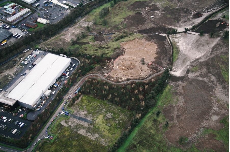
No. 156. Carnmeen and Lisduff: aerial view of rath at Lisduff.
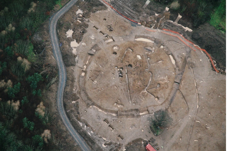
No. 156. Carnmeen and Lisduff: aerial view of rath at Lisduff (StudioLab).
Grid 43
This excavation area was located on the crest of a hill which fell sharply to the south. The main feature was a rectangular ditch enclosing an area measuring 10.25m north–south by 9.8m. It had an overall length of 47.79m and varied from 1.29m to 0.93m in width. Its sides were steeply sloped and its base varied from concave to flat. The western side of the ditch was the shallowest, 0.37m, and its eastern side was the deepest at 0.52m. The ditch had rounded corners at the north-western and south-eastern sides. A possible entranceway was identified, defined by a raised area at its north-eastern corner.
The ditch appeared to have silted up naturally, as was evident from several phases of natural siltation, with the exception of two deliberate deposits, one of which contained unidentified pottery and flint and the other a fragment of iron. Two shallow curvilinear gullies extended from the enclosure towards the western and north-eastern limits of excavation.
Grids 44/45
Four isolated pits, one of which had evidence of in situ burning in its upper fill, were identified in this area. These features were considered to be of limited archaeological significance.
Grid 47
The truncated remains of a burnt mound and a complex of pits were identified in this excavation area. A series of shallow, circular pits were uncovered here, all of which contained prehistoric (possibly early Neolithic) pottery. The burnt mound, which was located within an adjacent, waterlogged part of the site, was defined by two troughs, one of which had four stake-holes at its base. The fragmented remains of two spreads were also recorded, which are likely to represent the truncated remains of the burnt mound spread. A possible flint scraper and four unworked flint pieces were recovered from one of these spreads.
Artefacts and ecofacts
These excavations produced 446 sherds of prehistoric pottery, 288 sherds of early medieval pottery, 116 lithic objects, 80 sherds of post-medieval pottery and 28 small finds, including iron objects, clay pipe and a lignite ring. A total of 260 bulk soil samples were processed and separately there were seven metallurgical waste samples.