2011:028 - LINFORD: Loughdoo Road Wind Turbine, Antrim
County: Antrim
Site name: LINFORD: Loughdoo Road Wind Turbine
Sites and Monuments Record No.: N/A
Licence number: AE/11/123E
Author: Colin Dunlop, Northern Archaeological Consultancy Ltd.
Author/Organisation Address: Farset Enterprise Park, 638 Springfield Road, Belfast, BT12 7DY
Site type: Habitation site
Period/Dating: Bronze Age (2200 BC-801 BC)
ITM: E 731950m, N 907209m
Latitude, Longitude (decimal degrees): 54.895208, -5.942929
Excavations carried out here by B.B. Williams, DOE (NI), in the early 1990s (Excavations 1990, no. 5, and Excavations 1991, no. 7) uncovered evidence of Neolithic, Bronze Age, medieval and 17th-century activity on the site, which is now a scheduled area (ANT034-054). The current planning application was for a wind turbine, so only a small portion of the site was to be test-trenched. Eight mechanically excavated trenches were opened but only two contained archaeological material. A single hand-excavated trench across a prominent ridge that ran towards the scheduled area to the south revealed the feature to be a cultivation ridge, one of several that extended across the field. No archaeological material was uncovered.
Archaeological material was uncovered in the north-western ends of Trenches 1 and 2, and this area was then expanded to uncover the full extent of this material within the proposed development.
The features uncovered comprised a curving ditch, a section of the possible remains of a stone and earth bank on the external edge of the ditch, and a large black feature internal to the ditch. The only artefactual material was burnt flint within the large black feature, but considering the large quantity of naturally occurring flint within the subsoil this was not diagnostic. The investigation of these features was intended to gather further information to inform the planning decision, so a full excavation was not required by the NIEA. Box sections were put through each of these features to see whether function or date could be identified.
The three-day excavation has proven that there is a ditch within this area. Only the portion exposed during the excavation would be affected by the building of the wind turbine; the majority of the ditch is still preserved under the topsoil to the north of the excavation area. The ditch was c. 1.8m wide at the top, narrowing to 0.2m at its base, and contained numerous fills along its length. The ditch could be seen curving to the north-east in Box Section 3, whilst to the north of Box Section 1 a distinct and abrupt end to the ditch could be seen. Some flint was recovered from the ditch; it was undiagnostic and could not be dated to any particular period, although some pieces were struck. It is most likely that this is the ditch of a rath.
The area considered to be the interior of the rath contained six small features, namely stake- and post-holes. These were quite evenly spaced out and roughly in line with each other. They were probably the remains of a wooden structure/dwelling within the rath.
The dark spread identified during testing, F33, may have been the remains of a hearth area, as there were flecks of charcoal present. There was no other evidence of burning, however, and therefore it is possible that the hearth itself may have been raised and that the dark spread represents the hearth material dumped at some point after it fell into disuse. Alternatively it could be an occupation layer, simply a build-up of detritus from everyday life, which would explain the lack of evidence for burning.
The ‘mound’ feature may initially have been part of some sort of wall or walled feature, as some of the stones appeared to be ‘stacked’ on top of each other. This fill contained the only piece of pottery from the excavation, placing this fill, at least, tentatively in the Bronze Age. The evidence from the ditch shows that fill F29 from the mound fell into the ditch while it was only partially filled in, suggesting that the ditch was left open for some time and slowly began to silt up. Based on the features revealed during the excavation and the previous excavations in this area, it is most likely that the features found are Bronze Age in date, although it is impossible to say for certain without diagnostic artefacts or radiocarbon dating.
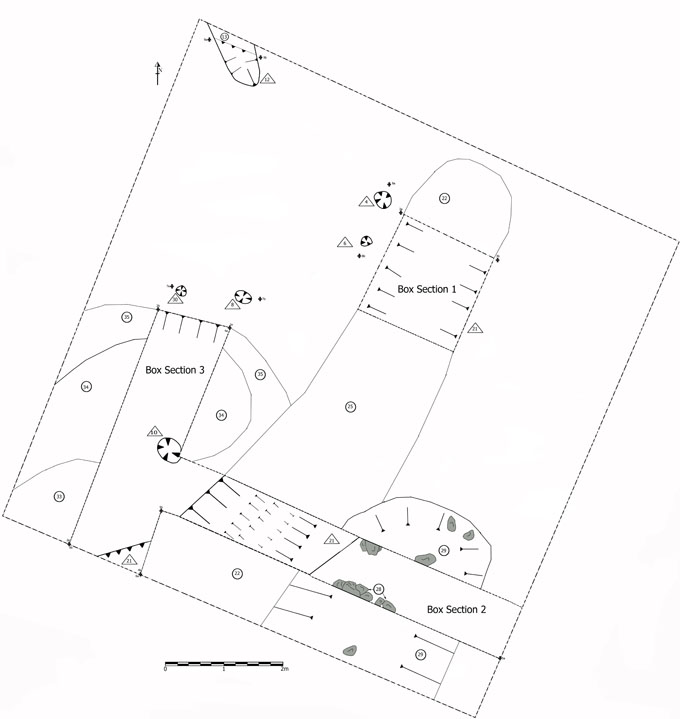
No. 28. Loughdoo Road Wind Turbine, Linford: post-excavation plan.