2011:015 - CARRICKFERGUS: YMCA, 30–34 Irish Quarter West, Antrim
County: Antrim
Site name: CARRICKFERGUS: YMCA, 30–34 Irish Quarter West
Sites and Monuments Record No.: N/A
Licence number: AE/11/033
Author: Sarah Nicol, Northern Archaeological Consultancy Ltd.
Author/Organisation Address: Farset Enterprise Park, 638 Springfield Road, Belfast BT12 7DY
Site type: Historic town
Period/Dating: Multi-period
ITM: E 741021m, N 887343m
Latitude, Longitude (decimal degrees): 54.714374, -5.811285
The site, for a single three-storey building, was situated on the western side of the modern-day town of Carrickfergus, in Irish Quarter West, an area beyond the original defended settlement and the later walled town. The lands within the site were occupied by Nos 30–34 Irish Quarter West and rear garden areas to the south of these frontage buildings. The site is bounded on the north by Irish Quarter West and on all other sides by pre-existing property boundaries. The boundary on the eastern side of the site was the only one to be demolished, and as it was of possible historical significance a photographic survey was undertaken along its length. The site is approximately 0.5km from the present shoreline of Belfast Lough.
Three areas of interest were identified on the site: the north-east corner, the western side and the southern boundary.
The north-east corner
On the outside of the original eastern boundary wall was a cobbled floor, S4, probably part of an alleyway. At the southern end of the cobbles was a small patch of repair. Associated with S4 were three bricks which appeared to be part of a small wall; the mortar for the wall continued both north-east and south-west, although the bricks had gone.
The western side
Beginning at a distance of 6m from the frontage and lying between the western site boundary wall and a distance of 5m from it was a series of walls and cobbled floors. The main feature was S7, a stone and mortar wall running north–south; this was abutted by wall S8 at its southern end and cut through by wall S9. Also abutting wall S7 were two floor surfaces, S11 at its north-western side and S22 at its southern end. To the south-west of cobbled floor S11 were two further cobbled surfaces, S12 and S20, on either side of a drain, C13. Cobbled surface S12 was cut along its southern edge by wall S10; to the south of S10 was a further cobbled surface, S14. It is likely that wall S10 was a continuation of S9, but unfortunately an early test pit cut through the wall. Given the amount of rubble on the site and the poor nature of wall S9/S10 this is not surprising. On the western end of wall S10 were a series of bricks which may have been part of a hearth, although this had been disturbed by a modern iron service pipe which ran along the site’s western boundary wall. To the south of these floors and walls were two red brick walls, S16 and S17, which formed a corner of a building identified on modern maps; S16 abutted stone wall S15. All of the walls and floors were dug into a layer of black organic-rich clay silt, F19. On the north-eastern side of the site F19 was overlain by F21, the remains of the modern rubble from the demolition of the buildings.
The oldest feature on the site was F19; this was a layer of soil which contained a large quantity of pottery, animal bone, metal and glass. One of the most interesting artefacts uncovered from the point of view of local interest was a ceramic hot-water bottle upon which was written ‘Wm Gorman & son, Carrickfergus’.
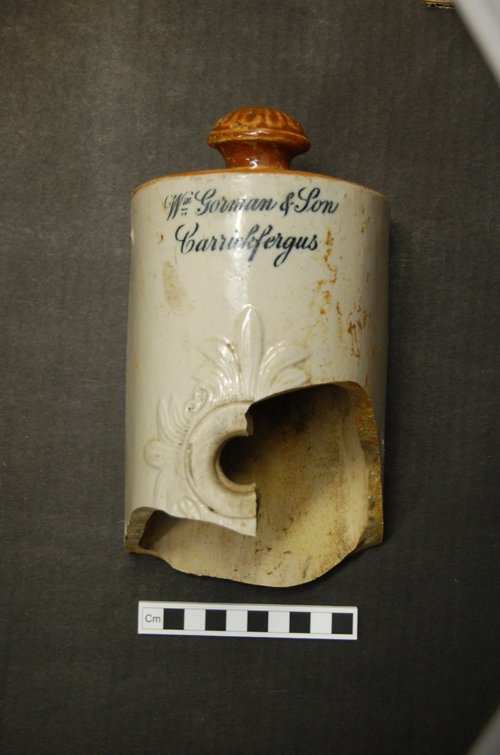
No. 15. YMCA, 30–34 Irish Quarter West, Carrickfergus: ceramic hot-water bottle.
The southern boundary
The walls uncovered at the back of the site, along the southern boundary, match up with the boundary wall that would once have run along the back of the site. Stone wall S24 would have been part of the boundary wall that ran up the western boundary, and running from this was stone wall S25. The relationship between these walls was unfortunately destroyed when a metal pipe was inserted along the western boundary wall. Wall S25 was interrupted along its length by a section of brick, S26; beyond this was stone wall S27, which continued until it met up with the demolished stone boundary wall. It is likely that S25 and S27 are part of the same wall, which was repaired with brick S26 in the recent past.
The continual occupation on the site from the 17th century through to the present day by a series of houses, built one on top of another, potentially made this site complicated. The earliest houses on the site were likely to have been single-storey thatched cottages, and it quickly became apparent that nothing of these earlier structures had survived; all that remained were the 18th–20th-century buildings. All of the finds from the site were dated to between the late 18th and 20th centuries, except for one sherd of pottery from c. 1400; this pre-dated all of the occupation on the site and may be considered a residual waste item from the historic core of the town.
The site boundary does not appear to have been set until the 1830s, with the first-edition 6in. OS map being the first to indicate the boundaries as they are today. This map records the first indication of a mill-race along the backs of the houses; prior to this it was shown running straight down one of the house boundaries. No sign of the mill-race was uncovered on the site; this means either that it ran further south or that the first-edition OS 6in. map was wrong. Without further investigation the exact location of the mill-race will remain unknown.
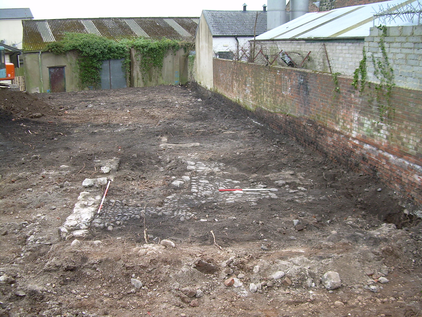
No. 15. YMCA, 30–34 Irish Quarter West, Carrickfergus: cobbled floor and wall.
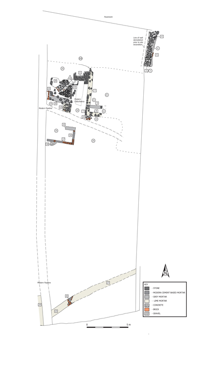
No. 15. YMCA, 30–34 Irish Quarter West, Carrickfergus: post-excavation plan of site.